Huế elevation
Huế (Thừa Thiên-Huế), Vietnam elevation is 8 meters and Huế elevation in feet is 26 ft above sea level [src 1]. Huế is a seat of a first-order administrative division (feature code) with elevation that is 120 meters (394 ft) smaller than average city elevation in Vietnam.
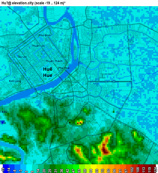
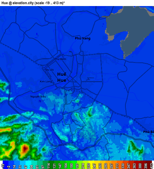
Below is the Elevation map of Huế, which displays elevation range with different colors. Scale of the first map is from -19 to 124 m (-62 to 407 ft) with average elevation of 10.5 meters (=34 ft) [note 1]
These maps also provides idea of topography and contour of this city, they are displayed at different zoom levels. More info about maps, scale and edge coordinates you can find below images.
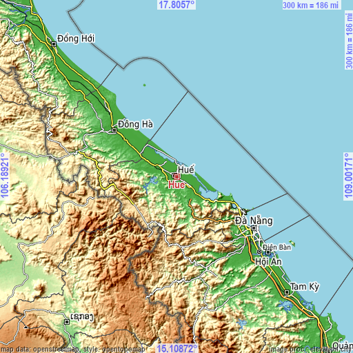
| \ | Map #1 | Map #2 | Topo.Map |
| Scale [m] | -19..124 m | -19..413 m | × |
| Scale [ft] | -62..407 ft | -62..1355 ft | × |
| Average | 10.5 m = 34 ft | 19.3 m = 63 ft | × |
| Width | 9.37 km = 5.8 mi | 18.74 km = 11.6 mi | 299.9 km = 186.3 mi |
| Height | 9.37 km = 5.8 mi | 18.74 km = 11.6 mi | 299.9 km = 186.3 mi |
| ↑Max Latitude | 16.504039° | 16.546169° | 17.8057° |
| Latitude at center | 16.4619° | 16.4619° | 16.4619° |
| ↓Min Latitude | 16.419752° | 16.377594° | 15.10872° |
| ← Min Longitude | 107.551515° | 107.507569° | 106.18921° |
| Longitude center | 107.59546° | 107.59546° | 107.59546° |
| →Max Longitude | 107.639405° | 107.683351° | 109.00171° |
Nearby cities:
Cities around Huế sort by population:
• Ðông Hà elevation 21 m
65.8 km,  306°
306°
• Liên Chiểu 13 m
74 km,  125°
125°
• Prao 502 m
60 km,  174°
174°
• Ái Tử 14 m
57.2 km, 306°
• Hải Lăng 11 m
44.8 km, 305°
• A Lưới 589 m
44 km,  241°
241°
• Khe Tre 65 m
35.1 km,  158°
158°
• Phú Lộc 13 m
34.6 km, 125°
• Phong Điền 14 m
28.1 km,  298°
298°
• Sịa 5 m
15.4 km,  324°
324°
• Hương Trà 11 m
14.6 km, 298°
• Phú Vang 8 m
12.9 km,  101°
101°


Sources and notes:
- [note 1] Map square and city borders are not equal. Map elevation data is calculated only from area inside that square.
- [src 1] Elevation data from geonames database provided with same terms of usage.
- [src 2] The elevation map of Huế is generated using elevation data from NASA's 3 arcsec (90m) resolution SRTM data.
- [src 3] Base (background) map © OpenStreetMap contributors tiles are generated by Geofabrik and OpenTopoMap.
Copyright & License:
This Huế Elevation Map is licensed under CC BY-SA. You may reuse any part from this page, if you give a proper credit by linking to this URL:
 More info on terms of use page.