Kiên Lương elevation
Kiên Lương (Kiến Giang, Kien Luong Town), Vietnam elevation is 6 meters and Kiên Lương elevation in feet is 20 ft above sea level [src 1]. Kiên Lương is a seat of a second-order administrative division (feature code) with elevation that is 122 meters (400 ft) smaller than average city elevation in Vietnam.
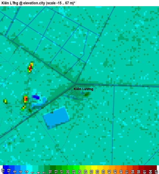
Below is the Elevation map of Kiên Lương, which displays elevation range with different colors. Scale of the first map is from -15 to 67 m (-49 to 220 ft) with average elevation of 2.5 meters (=8 ft) [note 1]
These maps also provides idea of topography and contour of this city, they are displayed at different zoom levels. More info about maps, scale and edge coordinates you can find below images.
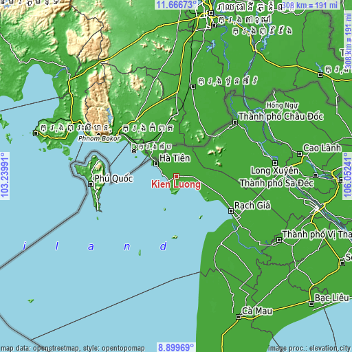
| \ | Map #1 | Topo.Map |
| Scale [m] | -15..67 m | × |
| Scale [ft] | -49..220 ft | × |
| Average | 2.5 m = 8 ft | × |
| Width | 9.62 km = 6 mi | 307.7 km = 191.2 mi |
| Height | 9.62 km = 6 mi | 307.7 km = 191.2 mi |
| ↑Max Latitude | 10.329476° | 11.66673° |
| Latitude at center | 10.28624° | 10.28624° |
| ↓Min Latitude | 10.242998° | 8.89969° |
| ← Min Longitude | 104.602215° | 103.23991° |
| Longitude center | 104.64616° | 104.64616° |
| →Max Longitude | 104.690105° | 106.05241° |
Nearby cities:
Cities around Kiên Lương sort by population:
• Rạch Giá elevation 13 m
56.5 km,  122°
122°
• Cho Dok 10 m
69 km,  48°
48°
• Hà Tiên 8 m
20.4 km,  301°
301°
• Dương Đông 8 m
75.5 km,  264°
264°
• Tân Hiệp 7 m
72.5 km,  105°
105°
• Cái Dầu 2 m
72.4 km,  63°
63°
• Minh Lương 5 m
70.6 km,  127°
127°
• An Biên 4 m
69.5 km,  138°
138°
• Núi Sập 7 m
67.9 km,  92°
92°
• Nhà Bàng 17 m
54.7 km, 46°
• Tri Tôn 9 m
41.5 km,  68°
68°
• Ngoc Hon Doc 4 m
33 km, 110°
Multilingual:
 En español:
Kiên Lương elevación 6 m.
 En France:
Kiên Lương élévation 6 m.
 Auf Deutsch:
Kiên Lương höhe über dem Meeresspiegel ist 6 m.

Sources and notes:
- [note 1] Map square and city borders are not equal. Map elevation data is calculated only from area inside that square.
- [src 1] Elevation data from geonames database provided with same terms of usage.
- [src 2] The elevation map of Kiên Lương is generated using elevation data from NASA's 3 arcsec (90m) resolution SRTM data.
- [src 3] Base (background) map © OpenStreetMap contributors tiles are generated by Geofabrik and OpenTopoMap.
Copyright & License:
This Kiên Lương Elevation Map is licensed under CC BY-SA. You may reuse any part from this page, if you give a proper credit by linking to this URL:
 More info on terms of use page.