Kon Tum elevation
Kon Tum, Vietnam elevation is 543 meters and Kon Tum elevation in feet is 1781 ft above sea level [src 1]. Kon Tum is a seat of a first-order administrative division (feature code) with elevation that is 415 meters (1362 ft) bigger than average city elevation in Vietnam.
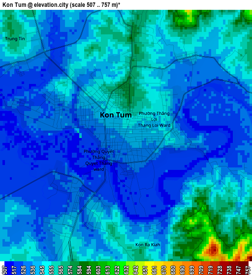
Below is the Elevation map of Kon Tum, which displays elevation range with different colors. Scale of the first map is from 507 to 757 m (1663 to 2484 ft) with average elevation of 541.9 meters (=1778 ft) [note 1]
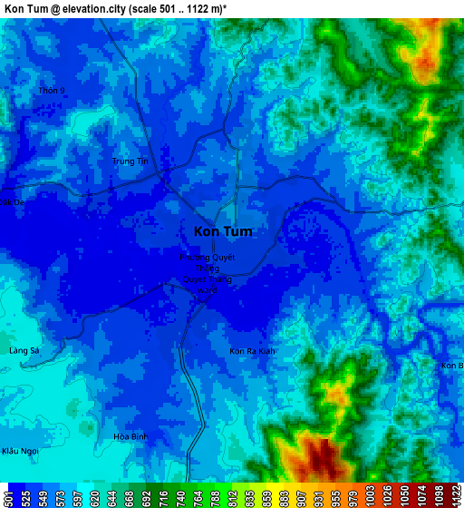
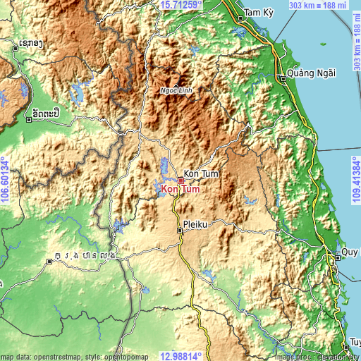
These maps also provides idea of topography and contour of this city, they are displayed at different zoom levels. More info about maps, scale and edge coordinates you can find below images.
| \ | Map #1 | Map #2 | Topo.Map |
| Scale [m] | 507..757 m | 501..1122 m | × |
| Scale [ft] | 1663..2484 ft | 1644..3681 ft | × |
| Average | 541.9 m = 1778 ft | 593.5 m = 1947 ft | × |
| Width | 9.47 km = 5.9 mi | 18.93 km = 11.8 mi | 302.9 km = 188.2 mi |
| Height | 9.47 km = 5.9 mi | 18.93 km = 11.8 mi | 303 km = 188.3 mi |
| ↑Max Latitude | 14.397079° | 14.43964° | 15.71259° |
| Latitude at center | 14.35451° | 14.35451° | 14.35451° |
| ↓Min Latitude | 14.311933° | 14.269347° | 12.98814° |
| ← Min Longitude | 107.963645° | 107.919699° | 106.60134° |
| Longitude center | 108.00759° | 108.00759° | 108.00759° |
| →Max Longitude | 108.051535° | 108.095481° | 109.41384° |
Nearby cities:
Cities around Kon Tum sort by population:
• Pleiku elevation 760 m
41.3 km,  181°
181°
• Chư Prông 512 m
67.7 km,  191°
191°
• Plei Kần 663 m
52.1 km,  318°
318°
• Ia Kha 586 m
47 km,  201°
201°
• Kon Dơng 737 m
43.8 km,  143°
143°
• Đăk Đoa 744 m
41.5 km,  164°
164°
• Măng Đen 1193 m
41 km,  48°
48°
• Đắk Tô 593 m
38.6 km,  331°
331°
• Đắk Rve 642 m
30.9 km,  56°
56°
• Phú Hòa 751 m
28.6 km, 188°
• Sa Thầy 546 m
24 km,  285°
285°
• Đắk Hà 602 m
20 km, 332°
Multilingual:
 En español:
Kon Tum elevación 543 m.
 En France:
Kon Tum élévation 543 m.


Sources and notes:
- [note 1] Map square and city borders are not equal. Map elevation data is calculated only from area inside that square.
- [src 1] Elevation data from geonames database provided with same terms of usage.
- [src 2] The elevation map of Kon Tum is generated using elevation data from NASA's 3 arcsec (90m) resolution SRTM data.
- [src 3] Base (background) map © OpenStreetMap contributors tiles are generated by Geofabrik and OpenTopoMap.
Copyright & License:
This Kon Tum Elevation Map is licensed under CC BY-SA. You may reuse any part from this page, if you give a proper credit by linking to this URL:
 More info on terms of use page.