Thanh Hóa elevation
Thanh Hóa, Vietnam elevation is 5 meters and Thanh Hóa elevation in feet is 16 ft above sea level [src 1]. Thanh Hóa is a seat of a first-order administrative division (feature code) with elevation that is 123 meters (404 ft) smaller than average city elevation in Vietnam.
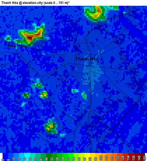
Below is the Elevation map of Thanh Hóa, which displays elevation range with different colors. Scale of the first map is from 0 to 151 m (0 to 495 ft) with average elevation of 8.8 meters (=29 ft) [note 1]
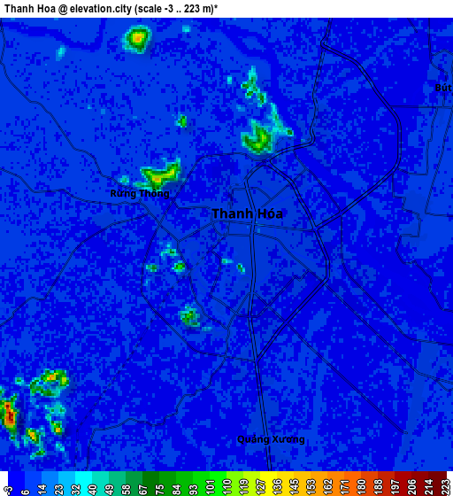
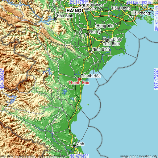
These maps also provides idea of topography and contour of this city, they are displayed at different zoom levels. More info about maps, scale and edge coordinates you can find below images.
| \ | Map #1 | Map #2 | Topo.Map |
| Scale [m] | 0..151 m | -3..223 m | × |
| Scale [ft] | 0..495 ft | -10..732 ft | × |
| Average | 8.8 m = 29 ft | 7.6 m = 25 ft | × |
| Width | 9.19 km = 5.7 mi | 18.39 km = 11.4 mi | 294.2 km = 182.8 mi |
| Height | 9.19 km = 5.7 mi | 18.39 km = 11.4 mi | 294.2 km = 182.8 mi |
| ↑Max Latitude | 19.841342° | 19.882673° | 21.11751° |
| Latitude at center | 19.8° | 19.8° | 19.8° |
| ↓Min Latitude | 19.758647° | 19.717284° | 18.47149° |
| ← Min Longitude | 105.722725° | 105.678779° | 104.36042° |
| Longitude center | 105.76667° | 105.76667° | 105.76667° |
| →Max Longitude | 105.810615° | 105.854561° | 107.17292° |
Nearby cities:
Cities around Thanh Hóa sort by population:
• Nga Sơn elevation 8 m
31.4 km,  42°
42°
• Thọ Xuân 18 m
29.5 km,  299°
299°
• Bến Sung 14 m
27.2 km,  226°
226°
• Hà Trung 9 m
25.3 km,  20°
20°
• Nông Cống 7 m
23.1 km,  212°
212°
• Quán Lào 14 m
22.6 km,  327°
327°
• Hậu Lộc 12 m
17.8 km, 44°
• Triệu Sơn 10 m
17.2 km,  277°
277°
• Vạn Hà 9 m
13.3 km,  316°
316°
• Bút Sơn 8 m
11.2 km,  55°
55°
• Quảng Xương 6 m
8 km,  167°
167°
• Rừng Thông 11 m
4.1 km, 300°
Multilingual:
 En español:
Thanh Hóa elevación 5 m.
 En France:
Thanh Hóa élévation 5 m.


Sources and notes:
- [note 1] Map square and city borders are not equal. Map elevation data is calculated only from area inside that square.
- [src 1] Elevation data from geonames database provided with same terms of usage.
- [src 2] The elevation map of Thanh Hóa is generated using elevation data from NASA's 3 arcsec (90m) resolution SRTM data.
- [src 3] Base (background) map © OpenStreetMap contributors tiles are generated by Geofabrik and OpenTopoMap.
Copyright & License:
This Thanh Hóa Elevation Map is licensed under CC BY-SA. You may reuse any part from this page, if you give a proper credit by linking to this URL:
 More info on terms of use page.