Thủ Dầu Một elevation
Thủ Dầu Một (Bình Dương), Vietnam elevation is 20 meters and Thủ Dầu Một elevation in feet is 66 ft above sea level [src 1]. Thủ Dầu Một is a seat of a first-order administrative division (feature code) with elevation that is 108 meters (354 ft) smaller than average city elevation in Vietnam.
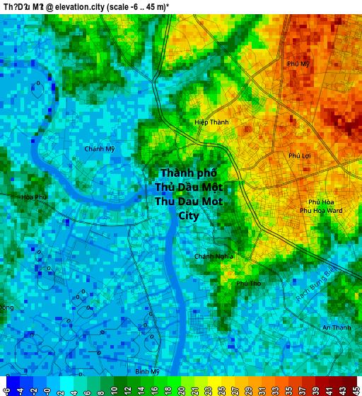
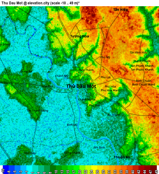
Below is the Elevation map of Thủ Dầu Một, which displays elevation range with different colors. Scale of the first map is from -6 to 45 m (-20 to 148 ft) with average elevation of 10.8 meters (=35 ft) [note 1]
These maps also provides idea of topography and contour of this city, they are displayed at different zoom levels. More info about maps, scale and edge coordinates you can find below images.
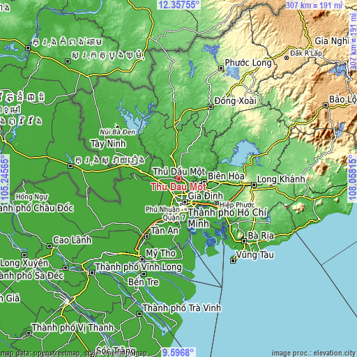
| \ | Map #1 | Map #2 | Topo.Map |
| Scale [m] | -6..45 m | -10..49 m | × |
| Scale [ft] | -20..148 ft | -33..161 ft | × |
| Average | 10.8 m = 35 ft | 13.5 m = 44 ft | × |
| Width | 9.59 km = 6 mi | 19.19 km = 11.9 mi | 307 km = 190.8 mi |
| Height | 9.59 km = 6 mi | 19.19 km = 11.9 mi | 307 km = 190.8 mi |
| ↑Max Latitude | 11.023538° | 11.066669° | 12.35755° |
| Latitude at center | 10.9804° | 10.9804° | 10.9804° |
| ↓Min Latitude | 10.937256° | 10.894106° | 9.5968° |
| ← Min Longitude | 106.607955° | 106.564009° | 105.24565° |
| Longitude center | 106.6519° | 106.6519° | 106.6519° |
| →Max Longitude | 106.695845° | 106.739791° | 108.05815° |
Nearby cities:
Cities around Thủ Dầu Một sort by population:
• Ho Chi Minh City elevation 7 m
17.7 km,  187°
187°
• Biên Hòa 6 m
19.2 km,  101°
101°
• Củ Chi 14 m
17.3 km,  267°
267°
• Quận Tân Phú 4 m
21.9 km,  184°
184°
• Quận Phú Nhuận 6 m
20.8 km,  172°
172°
• Quận Bình Thạnh 14 m
20.3 km, 166°
• Quận Chín 17 m
20.3 km,  140°
140°
• Thủ Đức 29 m
19.7 km, 138°
• Uyen Hung 39 m
18.8 km,  52°
52°
• Dĩ An 32 m
15.2 km,  122°
122°
• Hóc Môn 5 m
11.9 km,  211°
211°
• Lái Thiêu 11 m
9.9 km,  148°
148°
Multilingual:
 En español:
Thủ Dầu Một elevación 20 m.
 En France:
Thủ Dầu Một élévation 20 m.
 Auf Deutsch:
Thủ Dầu Một höhe über dem Meeresspiegel ist 20 m.

Sources and notes:
- [note 1] Map square and city borders are not equal. Map elevation data is calculated only from area inside that square.
- [src 1] Elevation data from geonames database provided with same terms of usage.
- [src 2] The elevation map of Thủ Dầu Một is generated using elevation data from NASA's 3 arcsec (90m) resolution SRTM data.
- [src 3] Base (background) map © OpenStreetMap contributors tiles are generated by Geofabrik and OpenTopoMap.
Copyright & License:
This Thủ Dầu Một Elevation Map is licensed under CC BY-SA. You may reuse any part from this page, if you give a proper credit by linking to this URL:
 More info on terms of use page.