Vĩnh Long elevation
Vĩnh Long, Vietnam elevation is 1 meters and Vĩnh Long elevation in feet is 3 ft above sea level [src 1]. Vĩnh Long is a seat of a first-order administrative division (feature code) with elevation that is 127 meters (417 ft) smaller than average city elevation in Vietnam.
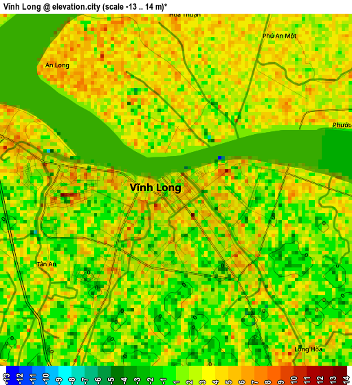
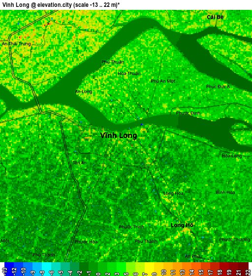
Below is the Elevation map of Vĩnh Long, which displays elevation range with different colors. Scale of the first map is from -13 to 14 m (-43 to 46 ft) with average elevation of 2.1 meters (=7 ft) [note 1]
These maps also provides idea of topography and contour of this city, they are displayed at different zoom levels. More info about maps, scale and edge coordinates you can find below images.
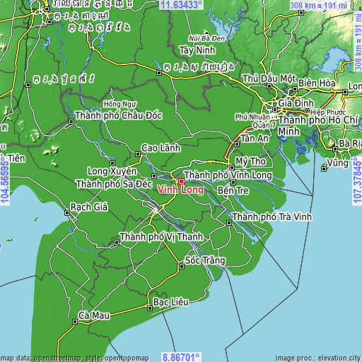
| \ | Map #1 | Map #2 | Topo.Map |
| Scale [m] | -13..14 m | -13..22 m | × |
| Scale [ft] | -43..46 ft | -43..72 ft | × |
| Average | 2.1 m = 7 ft | 2.2 m = 7 ft | × |
| Width | 9.62 km = 6 mi | 19.23 km = 11.9 mi | 307.7 km = 191.2 mi |
| Height | 9.62 km = 6 mi | 19.23 km = 11.9 mi | 307.7 km = 191.2 mi |
| ↑Max Latitude | 10.296931° | 10.340165° | 11.63433° |
| Latitude at center | 10.25369° | 10.25369° | 10.25369° |
| ↓Min Latitude | 10.210444° | 10.167191° | 8.86701° |
| ← Min Longitude | 105.928255° | 105.884309° | 104.56595° |
| Longitude center | 105.9722° | 105.9722° | 105.9722° |
| →Max Longitude | 106.016145° | 106.060091° | 107.37845° |
Nearby cities:
Cities around Vĩnh Long sort by population:
• Cần Thơ elevation 3 m
31.4 km,  219°
219°
• Sa Dec 1 m
24 km,  279°
279°
• Trà Ôn 5 m
32.8 km,  189°
189°
• Bình Thủy 5 m
32.3 km,  231°
231°
• Vũng Liêm 5 m
29.2 km,  126°
126°
• Bình Minh 5 m
26.4 km, 218°
• An Hòa 8 m
25.4 km, 280°
• Tam Bình 5 m
23.1 km,  172°
172°
• Cái Nhum 4 m
17.5 km,  120°
120°
• Chợ Lách 3 m
16.1 km,  87°
87°
• Cái Tàu Hạ 3 m
11.2 km,  273°
273°
• Long Hồ 3 m
8.1 km,  147°
147°
Multilingual:
 En español:
Vĩnh Long elevación 1 m.
 En France:
Vĩnh Long élévation 1 m.


Sources and notes:
- [note 1] Map square and city borders are not equal. Map elevation data is calculated only from area inside that square.
- [src 1] Elevation data from geonames database provided with same terms of usage.
- [src 2] The elevation map of Vĩnh Long is generated using elevation data from NASA's 3 arcsec (90m) resolution SRTM data.
- [src 3] Base (background) map © OpenStreetMap contributors tiles are generated by Geofabrik and OpenTopoMap.
Copyright & License:
This Vĩnh Long Elevation Map is licensed under CC BY-SA. You may reuse any part from this page, if you give a proper credit by linking to this URL:
 More info on terms of use page.