Vũng Tàu elevation
Vũng Tàu (Bà Rịa-Vũng Tàu), Vietnam elevation is 10 meters and Vũng Tàu elevation in feet is 33 ft above sea level [src 1]. Vũng Tàu is a populated place (feature code) with elevation that is 118 meters (387 ft) smaller than average city elevation in Vietnam.
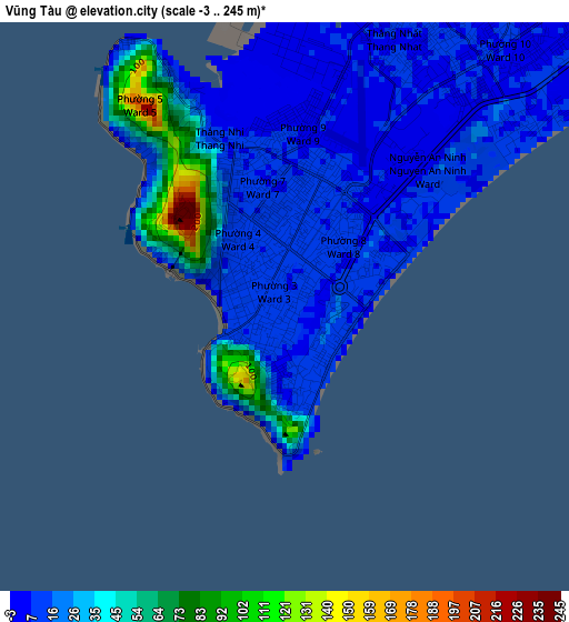
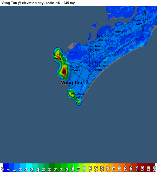
Below is the Elevation map of Vũng Tàu, which displays elevation range with different colors. Scale of the first map is from -3 to 245 m (-10 to 804 ft) with average elevation of 22.2 meters (=73 ft) [note 1]
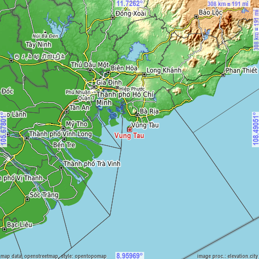
These maps also provides idea of topography and contour of this city, they are displayed at different zoom levels. More info about maps, scale and edge coordinates you can find below images.
| \ | Map #1 | Map #2 | Topo.Map |
| Scale [m] | -3..245 m | -16..245 m | × |
| Scale [ft] | -10..804 ft | -52..804 ft | × |
| Average | 22.2 m = 73 ft | 13.5 m = 44 ft | × |
| Width | 9.61 km = 6 mi | 19.23 km = 11.9 mi | 307.6 km = 191.1 mi |
| Height | 9.61 km = 6 mi | 19.23 km = 11.9 mi | 307.6 km = 191.1 mi |
| ↑Max Latitude | 10.389218° | 10.43244° | 11.7262° |
| Latitude at center | 10.34599° | 10.34599° | 10.34599° |
| ↓Min Latitude | 10.302756° | 10.259516° | 8.95969° |
| ← Min Longitude | 107.040315° | 106.996369° | 105.67801° |
| Longitude center | 107.08426° | 107.08426° | 107.08426° |
| →Max Longitude | 107.128205° | 107.172151° | 108.49051° |
Nearby cities:
Cities around Vũng Tàu sort by population:
• Thị Xã Phú Mỹ elevation 53 m
25.2 km,  11°
11°
• Cần Giờ 5 m
15.9 km,  297°
297°
• Long Thành 19 m
51.4 km,  343°
343°
• Nhơn Trạch 26 m
47.3 km,  332°
332°
• Bình Đại 2 m
46.4 km,  247°
247°
• Tân Hòa 4 m
40.9 km,  265°
265°
• Thị Trấn Phước Bửu 19 m
40.6 km,  58°
58°
• Thị Trấn Ngải Giao 119 m
37.9 km,  27°
27°
• Thị Trấn Phú Mỹ 9 m
28.8 km,  353°
353°
• Phuoc Tho 42 m
25.9 km,  51°
51°
• Thị Trấn Long Điền 11 m
20.9 km,  42°
42°
• Thành Phố Bà Rịa 8 m
19.1 km, 28°
Multilingual:
 En español:
Vung Tau elevación 10 m.
 En France:
Cap-Saint-Jacques, Ville du Cap, Vũng Tàu élévation 10 m.


Sources and notes:
- [note 1] Map square and city borders are not equal. Map elevation data is calculated only from area inside that square.
- [src 1] Elevation data from geonames database provided with same terms of usage.
- [src 2] The elevation map of Vũng Tàu is generated using elevation data from NASA's 3 arcsec (90m) resolution SRTM data.
- [src 3] Base (background) map © OpenStreetMap contributors tiles are generated by Geofabrik and OpenTopoMap.
Copyright & License:
This Vũng Tàu Elevation Map is licensed under CC BY-SA. You may reuse any part from this page, if you give a proper credit by linking to this URL:
 More info on terms of use page.