Yên Vinh elevation
Yên Vinh (Nghệ An), Vietnam elevation is 12 meters and Yên Vinh elevation in feet is 39 ft above sea level [src 1]. Yên Vinh is a populated place (feature code) with elevation that is 116 meters (381 ft) smaller than average city elevation in Vietnam.
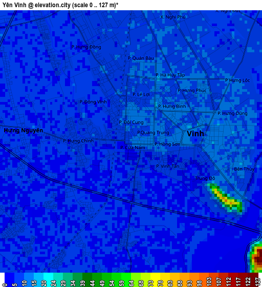
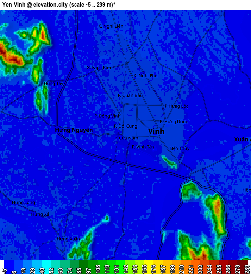
Below is the Elevation map of Yên Vinh, which displays elevation range with different colors. Scale of the first map is from 0 to 127 m (0 to 417 ft) with average elevation of 6.9 meters (=23 ft) [note 1]
These maps also provides idea of topography and contour of this city, they are displayed at different zoom levels. More info about maps, scale and edge coordinates you can find below images.
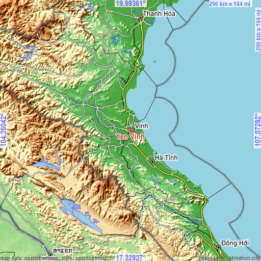
| \ | Map #1 | Map #2 | Topo.Map |
| Scale [m] | 0..127 m | -5..289 m | × |
| Scale [ft] | 0..417 ft | -16..948 ft | × |
| Average | 6.9 m = 23 ft | 12.8 m = 42 ft | × |
| Width | 9.26 km = 5.8 mi | 18.52 km = 11.5 mi | 296.2 km = 184 mi |
| Height | 9.26 km = 5.8 mi | 18.52 km = 11.5 mi | 296.3 km = 184.1 mi |
| ↑Max Latitude | 18.708299° | 18.749917° | 19.99361° |
| Latitude at center | 18.66667° | 18.66667° | 18.66667° |
| ↓Min Latitude | 18.625031° | 18.583382° | 17.32927° |
| ← Min Longitude | 105.622725° | 105.578779° | 104.26042° |
| Longitude center | 105.66667° | 105.66667° | 105.66667° |
| →Max Longitude | 105.710615° | 105.754561° | 107.07292° |
Nearby cities:
Cities around Yên Vinh sort by population:
• Vinh elevation 12 m
2.8 km,  74°
74°
• Thạch Hà 10 m
39 km,  148°
148°
• Thanh Chương 22 m
37.2 km,  289°
289°
• Vũ Quang 16 m
35.7 km,  208°
208°
• Diễn Châu 9 m
35.2 km,  348°
348°
• Phố Châu 17 m
30.7 km,  236°
236°
• Nghèn 8 m
26.8 km, 153°
• Nam Đàn 14 m
18 km,  281°
281°
• Đức Thọ 8 m
16.7 km, 211°
• Quán Hành 11 m
12.7 km, 350°
• Nghi Xuân 7 m
9.4 km,  93°
93°
• Hưng Nguyên 8 m
4 km, 277°
Multilingual:
 En español:
Yên Vinh elevación 12 m.
 En France:
Yên Vinh élévation 12 m.


Sources and notes:
- [note 1] Map square and city borders are not equal. Map elevation data is calculated only from area inside that square.
- [src 1] Elevation data from geonames database provided with same terms of usage.
- [src 2] The elevation map of Yên Vinh is generated using elevation data from NASA's 3 arcsec (90m) resolution SRTM data.
- [src 3] Base (background) map © OpenStreetMap contributors tiles are generated by Geofabrik and OpenTopoMap.
Copyright & License:
This Yên Vinh Elevation Map is licensed under CC BY-SA. You may reuse any part from this page, if you give a proper credit by linking to this URL:
 More info on terms of use page.