Thị Trấn Tân Thành elevation
Thị Trấn Tân Thành (Đồng Tháp), Vietnam elevation is 1 meters and Thị Trấn Tân Thành elevation in feet is 3 ft above sea level [src 1]. Thị Trấn Tân Thành is a populated place (feature code) with elevation that is 127 meters (417 ft) smaller than average city elevation in Vietnam.
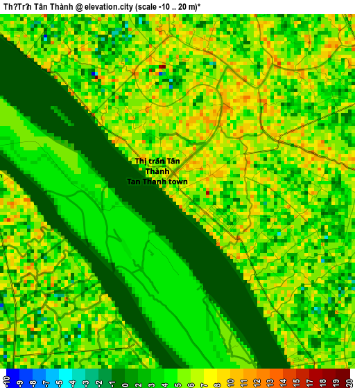
Below is the Elevation map of Thị Trấn Tân Thành, which displays elevation range with different colors. Scale of the first map is from -10 to 20 m (-33 to 66 ft) with average elevation of 4.5 meters (=15 ft) [note 1]
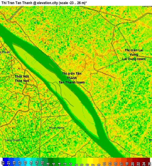
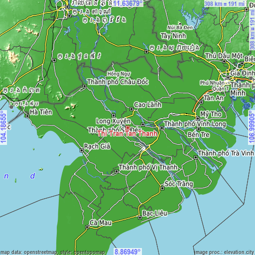
These maps also provides idea of topography and contour of this city, they are displayed at different zoom levels. More info about maps, scale and edge coordinates you can find below images.
| \ | Map #1 | Map #2 | Topo.Map |
| Scale [m] | -10..20 m | -23..26 m | × |
| Scale [ft] | -33..66 ft | -75..85 ft | × |
| Average | 4.5 m = 15 ft | 4.2 m = 14 ft | × |
| Width | 9.62 km = 6 mi | 19.23 km = 11.9 mi | 307.7 km = 191.2 mi |
| Height | 9.62 km = 6 mi | 19.23 km = 11.9 mi | 307.7 km = 191.2 mi |
| ↑Max Latitude | 10.2994° | 10.342634° | 11.63679° |
| Latitude at center | 10.25616° | 10.25616° | 10.25616° |
| ↓Min Latitude | 10.212914° | 10.169662° | 8.86949° |
| ← Min Longitude | 105.548855° | 105.504909° | 104.18655° |
| Longitude center | 105.5928° | 105.5928° | 105.5928° |
| →Max Longitude | 105.636745° | 105.680691° | 106.99905° |
Nearby cities:
Cities around Thị Trấn Tân Thành sort by population:
• Sa Dec elevation 1 m
18.3 km,  77°
77°
• Long Xuyên 8 m
22.5 km,  310°
310°
• Cao Lãnh 5 m
23.1 km,  10°
10°
• Cờ Đỏ 4 m
25.4 km,  224°
224°
• Mỹ Thọ 7 m
23.6 km,  28°
28°
• Vĩnh Thạnh 3 m
21.6 km,  260°
260°
• Thới Lai 6 m
21.6 km,  189°
189°
• An Hòa 8 m
17.2 km,  74°
74°
• Ô Môn 5 m
16.6 km,  168°
168°
• Lấp Vò 9 m
14.2 km,  325°
325°
• Lai Vung 4 m
8.3 km, 65°
• Thốt Nốt 6 m
6.7 km,  285°
285°
Multilingual:
 En español:
Thị Trấn Tân Thành elevación 1 m.
 En France:
Thị Trấn Tân Thành élévation 1 m.
 Auf Deutsch:
Thị Trấn Tân Thành höhe über dem Meeresspiegel ist 1 m.

Sources and notes:
- [note 1] Map square and city borders are not equal. Map elevation data is calculated only from area inside that square.
- [src 1] Elevation data from geonames database provided with same terms of usage.
- [src 2] The elevation map of Thị Trấn Tân Thành is generated using elevation data from NASA's 3 arcsec (90m) resolution SRTM data.
- [src 3] Base (background) map © OpenStreetMap contributors tiles are generated by Geofabrik and OpenTopoMap.
Copyright & License:
This Thị Trấn Tân Thành Elevation Map is licensed under CC BY-SA. You may reuse any part from this page, if you give a proper credit by linking to this URL:
 More info on terms of use page.