Đắk Glei elevation
Đắk Glei (Kon Tum), Vietnam elevation is 699 meters and Đắk Glei elevation in feet is 2293 ft above sea level [src 1]. Đắk Glei is a seat of a second-order administrative division (feature code) with elevation that is 571 meters (1873 ft) bigger than average city elevation in Vietnam.
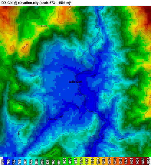
Below is the Elevation map of Đắk Glei, which displays elevation range with different colors. Scale of the first map is from 673 to 1501 m (2208 to 4925 ft) with average elevation of 888.5 meters (=2915 ft) [note 1]
These maps also provides idea of topography and contour of this city, they are displayed at different zoom levels. More info about maps, scale and edge coordinates you can find below images.
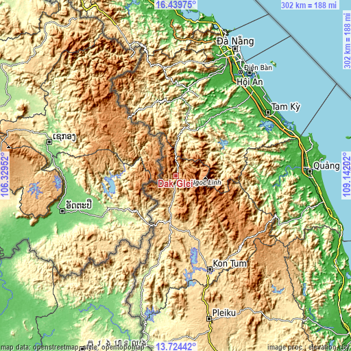
| \ | Map #1 | Topo.Map |
| Scale [m] | 673..1501 m | × |
| Scale [ft] | 2208..4925 ft | × |
| Average | 888.5 m = 2915 ft | × |
| Width | 9.44 km = 5.9 mi | 301.9 km = 187.6 mi |
| Height | 9.44 km = 5.9 mi | 301.9 km = 187.6 mi |
| ↑Max Latitude | 15.128846° | 16.43975° |
| Latitude at center | 15.08642° | 15.08642° |
| ↓Min Latitude | 15.043985° | 13.72442° |
| ← Min Longitude | 107.691825° | 106.32952° |
| Longitude center | 107.73577° | 107.73577° |
| →Max Longitude | 107.779715° | 109.14202° |
Nearby cities:
Cities around Đắk Glei sort by population:
• Măng Đen elevation 1193 m
80.5 km,  132°
132°
• Sơn Hà 68 m
79 km,  93°
93°
• Tiên Phước 54 m
75.9 km,  53°
53°
• Sa Thầy 546 m
75 km,  175°
175°
• Thạnh Mỹ 52 m
74.5 km,  8°
8°
• Doug An 40 m
68.5 km,  36°
36°
• Tây Trà 222 m
67.6 km,  82°
82°
• Đắk Hà 602 m
66.7 km,  162°
162°
• Trà My 110 m
59.2 km,  61°
61°
• Đắk Tô 593 m
48.6 km,  166°
166°
• Plei Kần 663 m
42.7 km,  187°
187°
• Khâm Đức 395 m
40.4 km, 8°
Multilingual:
 En español:
Đắk Glei elevación 699 m.
 En France:
Đắk Glei élévation 699 m.
 Auf Deutsch:
Đắk Glei höhe über dem Meeresspiegel ist 699 m.

Sources and notes:
- [note 1] Map square and city borders are not equal. Map elevation data is calculated only from area inside that square.
- [src 1] Elevation data from geonames database provided with same terms of usage.
- [src 2] The elevation map of Đắk Glei is generated using elevation data from NASA's 3 arcsec (90m) resolution SRTM data.
- [src 3] Base (background) map © OpenStreetMap contributors tiles are generated by Geofabrik and OpenTopoMap.
Copyright & License:
This Đắk Glei Elevation Map is licensed under CC BY-SA. You may reuse any part from this page, if you give a proper credit by linking to this URL:
 More info on terms of use page.