Thị Trấn Vinh Quang elevation
Thị Trấn Vinh Quang (Hà Giang), Vietnam elevation is 470 meters and Thị Trấn Vinh Quang elevation in feet is 1542 ft above sea level [src 1]. Thị Trấn Vinh Quang is a seat of a second-order administrative division (feature code) with elevation that is 342 meters (1122 ft) bigger than average city elevation in Vietnam.
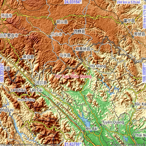
Below is the Elevation map of Thị Trấn Vinh Quang, which displays elevation range with different colors. Scale of the first map is from 371 to 1583 m (1217 to 5194 ft) with average elevation of 752.1 meters (=2468 ft) [note 1]
These maps also provides idea of topography and contour of this city, they are displayed at different zoom levels. More info about maps, scale and edge coordinates you can find below images.

| \ | Map #1 | Topo.Map |
| Scale [m] | 371..1583 m | × |
| Scale [ft] | 1217..5194 ft | × |
| Average | 752.1 m = 2468 ft | × |
| Width | 9.01 km = 5.6 mi | 288.4 km = 179.2 mi |
| Height | 9.01 km = 5.6 mi | 288.4 km = 179.2 mi |
| ↑Max Latitude | 22.781373° | 24.03154° |
| Latitude at center | 22.74085° | 22.74085° |
| ↓Min Latitude | 22.700315° | 21.43786° |
| ← Min Longitude | 104.635615° | 103.27331° |
| Longitude center | 104.67956° | 104.67956° |
| →Max Longitude | 104.723505° | 106.08581° |
Nearby cities:
Cities around Thị Trấn Vinh Quang sort by population:
• Hà Giang elevation 107 m
32.5 km,  73°
73°
• Thị Trấn Yên Minh 434 m
63.2 km,  48°
48°
• Thị Trấn Phố Ràng 87 m
60.1 km,  200°
200°
• Thị Trấn Mường Khương 771 m
57.3 km,  272°
272°
• Thị Trấn Vĩnh Tuy 53 m
56.2 km,  157°
157°
• Thị Trấn Tam Sơn 874 m
48.2 km,  41°
41°
• Bắc Hà 908 m
45.6 km,  240°
240°
• Si Ma Cai 1065 m
41.4 km,  262°
262°
• Thị Trấn Việt Quang 111 m
38.5 km, 160°
• Yên Bình 112 m
38.2 km, 195°
• Thị Trấn Vị Xuyên 93 m
32.1 km,  104°
104°
• Thị Trấn Việt Lâm 79 m
31.5 km,  114°
114°
Multilingual:
 En español:
Thị Trấn Vinh Quang elevación 470 m.
 En France:
Thị Trấn Vinh Quang élévation 470 m.
 Auf Deutsch:
Thị Trấn Vinh Quang höhe über dem Meeresspiegel ist 470 m.
 На русском:
Thị Trấn Vinh Quang высота над уровнем моря 470 м
Sources and notes:
- [note 1] Map square and city borders are not equal. Map elevation data is calculated only from area inside that square.
- [src 1] Elevation data from geonames database provided with same terms of usage.
- [src 2] The elevation map of Thị Trấn Vinh Quang is generated using elevation data from NASA's 3 arcsec (90m) resolution SRTM data.
- [src 3] Base (background) map © OpenStreetMap contributors tiles are generated by Geofabrik and OpenTopoMap.
Copyright & License:
This Thị Trấn Vinh Quang Elevation Map is licensed under CC BY-SA. You may reuse any part from this page, if you give a proper credit by linking to this URL:
 More info on terms of use page.