Acarigua elevation
Acarigua (Portuguesa, Municipio Páez), Venezuela elevation is 189 meters and Acarigua elevation in feet is 620 ft above sea level [src 1]. Acarigua is a seat of a second-order administrative division (feature code) with elevation that is 192 meters (630 ft) smaller than average city elevation in Venezuela.
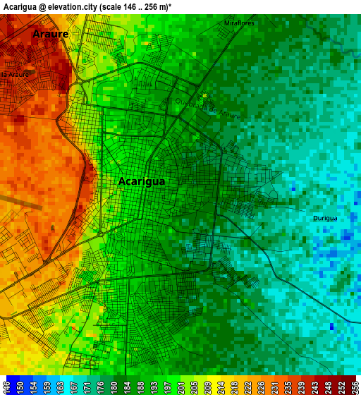
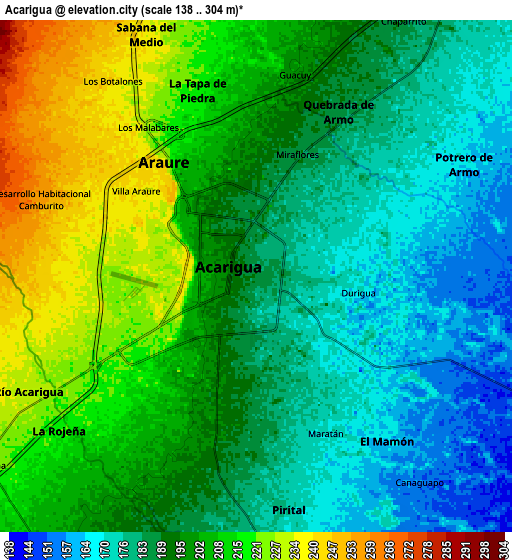
Below is the Elevation map of Acarigua, which displays elevation range with different colors. Scale of the first map is from 146 to 256 m (479 to 840 ft) with average elevation of 192.7 meters (=632 ft) [note 1]
These maps also provides idea of topography and contour of this city, they are displayed at different zoom levels. More info about maps, scale and edge coordinates you can find below images.
| \ | Map #1 | Map #2 | Topo.Map |
| Scale [m] | 146..256 m | 138..304 m | × |
| Scale [ft] | 479..840 ft | 453..997 ft | × |
| Average | 192.7 m = 632 ft | 195.8 m = 642 ft | × |
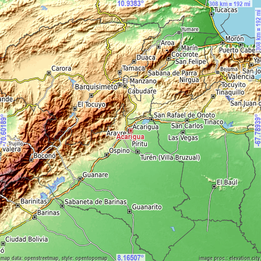
| Width | 9.64 km = 6 mi | 19.27 km = 12 mi | 308.4 km = 191.6 mi |
| Height | 9.64 km = 6 mi | 19.27 km = 12 mi | 308.4 km = 191.6 mi |
| ↑Max Latitude | 9.597843° | 9.64117° | 10.9383° |
| Latitude at center | 9.55451° | 9.55451° | 9.55451° |
| ↓Min Latitude | 9.511172° | 9.467828° | 8.16507° |
| ← Min Longitude | -69.239585° | -69.283531° | -70.60189° |
| Longitude center | -69.19564° | -69.19564° | -69.19564° |
| →Max Longitude | -69.151695° | -69.107749° | -67.78939° |
Nearby cities:
Cities around Acarigua sort by population:
• Araure elevation 217 m
5.6 km,  302°
302°
• Los Rastrojos 446 m
52.7 km,  354°
354°
• Villa Bruzual 122 m
26.1 km,  161°
161°
• Sanare 1207 m
54.7 km,  293°
293°
• El Playón 82 m
53.1 km, 161°
• Cabudare 505 m
53 km, 352°
• Ospino 184 m
40.4 km,  224°
224°
• Cojedes 147 m
31.4 km,  76°
76°
• San Rafael de Onoto 152 m
28 km,  60°
60°
• Sarare 269 m
25.5 km,  8°
8°
• Píritu 156 m
20.5 km,  184°
184°
• Agua Blanca 218 m
15.4 km,  39°
39°
Multilingual:
 En español:
Acarigua elevación 189 m.
 En France:
Acarigua élévation 189 m.
 Auf Deutsch:
Acarigua höhe über dem Meeresspiegel ist 189 m.

Sources and notes:
- [note 1] Map square and city borders are not equal. Map elevation data is calculated only from area inside that square.
- [src 1] Elevation data from geonames database provided with same terms of usage.
- [src 2] The elevation map of Acarigua is generated using elevation data from NASA's 3 arcsec (90m) resolution SRTM data.
- [src 3] Base (background) map © OpenStreetMap contributors tiles are generated by Geofabrik and OpenTopoMap.
Copyright & License:
This Acarigua Elevation Map is licensed under CC BY-SA. You may reuse any part from this page, if you give a proper credit by linking to this URL:
 More info on terms of use page.