Cantaura elevation
Cantaura (Anzoátegui, Municipio Pedro María Freites), Venezuela elevation is 263 meters and Cantaura elevation in feet is 863 ft above sea level [src 1]. Cantaura is a seat of a second-order administrative division (feature code) with elevation that is 118 meters (387 ft) smaller than average city elevation in Venezuela.
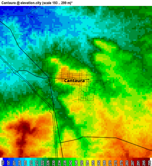
Below is the Elevation map of Cantaura, which displays elevation range with different colors. Scale of the first map is from 193 to 299 m (633 to 981 ft) with average elevation of 237.5 meters (=779 ft) [note 1]
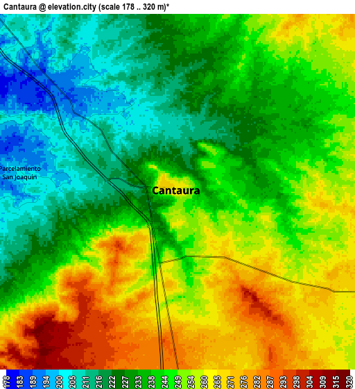
These maps also provides idea of topography and contour of this city, they are displayed at different zoom levels. More info about maps, scale and edge coordinates you can find below images.
| \ | Map #1 | Map #2 | Topo.Map |
| Scale [m] | 193..299 m | 178..320 m | × |
| Scale [ft] | 633..981 ft | 584..1050 ft | × |
| Average | 237.5 m = 779 ft | 242.5 m = 796 ft | × |
| Width | 9.64 km = 6 mi | 19.29 km = 12 mi | 308.6 km = 191.8 mi |
| Height | 9.64 km = 6 mi | 19.29 km = 12 mi | 308.6 km = 191.8 mi |
| ↑Max Latitude | 9.349074° | 9.392433° | 10.69057° |
| Latitude at center | 9.30571° | 9.30571° | 9.30571° |
| ↓Min Latitude | 9.26234° | 9.218965° | 7.91535° |
| ← Min Longitude | -64.402355° | -64.446301° | -65.76466° |
| Longitude center | -64.35841° | -64.35841° | -64.35841° |
| →Max Longitude | -64.314465° | -64.270519° | -62.95216° |
Nearby cities:
Cities around Cantaura sort by population:
• El Tigre elevation 276 m
47.8 km,  165°
165°
• Anaco 208 m
18 km,  319°
319°
• San José de Guanipa 261 m
51.1 km,  155°
155°
• Onoto 28 m
97.2 km,  289°
289°
• Punta de Mata 246 m
92.7 km,  62°
62°
• Santa Bárbara 159 m
88.7 km,  67°
67°
• El Chaparro 94 m
74.3 km,  256°
256°
• Aguasay 218 m
70.1 km,  79°
79°
• Pariaguán 276 m
64.3 km,  216°
216°
• Aragua de Barcelona 110 m
54.3 km, 287°
• San Mateo 136 m
52.6 km,  336°
336°
• Santa Ana 176 m
32.5 km,  269°
269°
Multilingual:
 En español:
Cantaura elevación 263 m.
 En France:
Cantaura élévation 263 m.
 Auf Deutsch:
Cantaura höhe über dem Meeresspiegel ist 263 m.

Sources and notes:
- [note 1] Map square and city borders are not equal. Map elevation data is calculated only from area inside that square.
- [src 1] Elevation data from geonames database provided with same terms of usage.
- [src 2] The elevation map of Cantaura is generated using elevation data from NASA's 3 arcsec (90m) resolution SRTM data.
- [src 3] Base (background) map © OpenStreetMap contributors tiles are generated by Geofabrik and OpenTopoMap.
Copyright & License:
This Cantaura Elevation Map is licensed under CC BY-SA. You may reuse any part from this page, if you give a proper credit by linking to this URL:
 More info on terms of use page.