Carora elevation
Carora (Lara, Municipio Torres), Venezuela elevation is 539 meters and Carora elevation in feet is 1768 ft above sea level [src 1]. Carora is a seat of a second-order administrative division (feature code) with elevation that is 158 meters (518 ft) bigger than average city elevation in Venezuela.
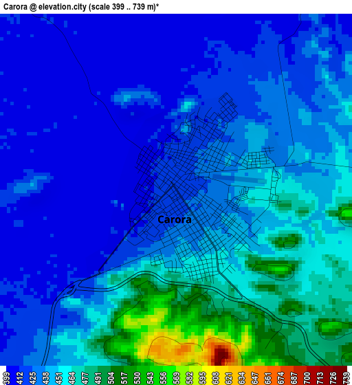
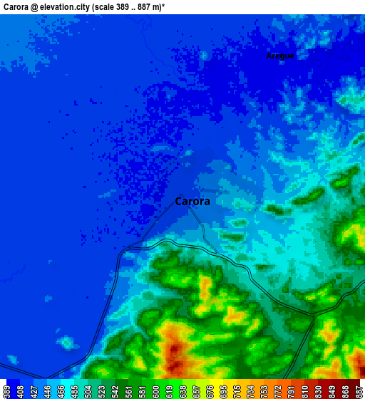
Below is the Elevation map of Carora, which displays elevation range with different colors. Scale of the first map is from 399 to 739 m (1309 to 2425 ft) with average elevation of 441.9 meters (=1450 ft) [note 1]
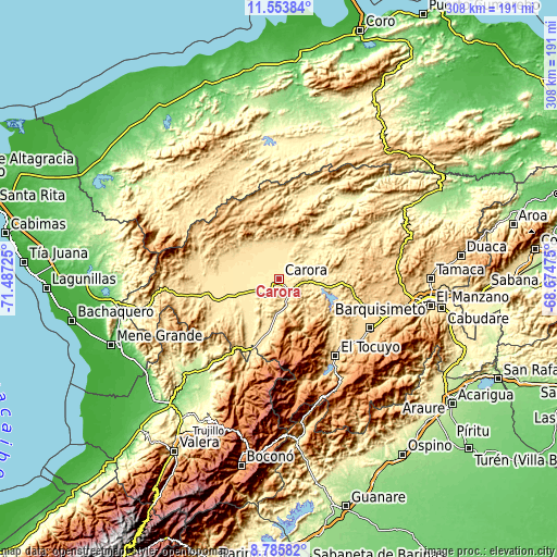
These maps also provides idea of topography and contour of this city, they are displayed at different zoom levels. More info about maps, scale and edge coordinates you can find below images.
| \ | Map #1 | Map #2 | Topo.Map |
| Scale [m] | 399..739 m | 389..887 m | × |
| Scale [ft] | 1309..2425 ft | 1276..2910 ft | × |
| Average | 441.9 m = 1450 ft | 463.3 m = 1520 ft | × |
| Width | 9.62 km = 6 mi | 19.24 km = 12 mi | 307.8 km = 191.3 mi |
| Height | 9.62 km = 6 mi | 19.24 km = 12 mi | 307.8 km = 191.3 mi |
| ↑Max Latitude | 10.216082° | 10.259327° | 11.55384° |
| Latitude at center | 10.17283° | 10.17283° | 10.17283° |
| ↓Min Latitude | 10.129573° | 10.086309° | 8.78582° |
| ← Min Longitude | -70.124945° | -70.168891° | -71.48725° |
| Longitude center | -70.081° | -70.081° | -70.081° |
| →Max Longitude | -70.037055° | -69.993109° | -68.67475° |
Nearby cities:
Cities around Carora sort by population:
• Barquisimeto elevation 606 m
80.2 km,  98°
98°
• El Tocuyo 616 m
53.2 km,  143°
143°
• Quíbor 695 m
57.3 km,  118°
118°
• Cabudare 505 m
91.1 km, 100°
• Biscucuy 639 m
91 km,  173°
173°
• Campo Elías 1078 m
86.6 km,  178°
178°
• Paraíso de Chabasquén 641 m
83.5 km, 169°
• El Paradero 323 m
73.5 km,  232°
232°
• Chejendé 986 m
68.6 km,  206°
206°
• Sanare 1207 m
66.3 km,  134°
134°
• Carache 1210 m
62.6 km,  194°
194°
• Siquisique 281 m
60.7 km,  43°
43°
Multilingual:
 En español:
Carora elevación 539 m.
 En France:
Carora élévation 539 m.


Sources and notes:
- [note 1] Map square and city borders are not equal. Map elevation data is calculated only from area inside that square.
- [src 1] Elevation data from geonames database provided with same terms of usage.
- [src 2] The elevation map of Carora is generated using elevation data from NASA's 3 arcsec (90m) resolution SRTM data.
- [src 3] Base (background) map © OpenStreetMap contributors tiles are generated by Geofabrik and OpenTopoMap.
Copyright & License:
This Carora Elevation Map is licensed under CC BY-SA. You may reuse any part from this page, if you give a proper credit by linking to this URL:
 More info on terms of use page.