Catia La Mar elevation
Catia La Mar (Vargas), Venezuela elevation is 37 meters and Catia La Mar elevation in feet is 121 ft above sea level [src 1]. Catia La Mar is a seat of a third-order administrative division (feature code) with elevation that is 344 meters (1129 ft) smaller than average city elevation in Venezuela.
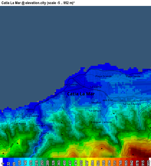
Below is the Elevation map of Catia La Mar, which displays elevation range with different colors. Scale of the first map is from -5 to 952 m (-16 to 3123 ft) with average elevation of 232.1 meters (=761 ft) [note 1]
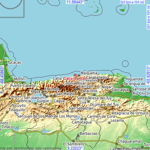
These maps also provides idea of topography and contour of this city, they are displayed at different zoom levels. More info about maps, scale and edge coordinates you can find below images.
| \ | Map #1 | Map #2 | Topo.Map |
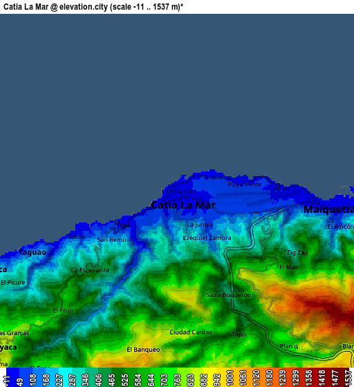
| Scale [m] | -5..952 m | -11..1537 m | × |
| Scale [ft] | -16..3123 ft | -36..5043 ft | × |
| Average | 232.1 m = 761 ft | 499.2 m = 1638 ft | × |
| Width | 9.61 km = 6 mi | 19.21 km = 11.9 mi | 307.4 km = 191 mi |
| Height | 9.61 km = 6 mi | 19.21 km = 11.9 mi | 307.4 km = 191 mi |
| ↑Max Latitude | 10.648642° | 10.691827° | 11.98443° |
| Latitude at center | 10.60545° | 10.60545° | 10.60545° |
| ↓Min Latitude | 10.562252° | 10.519049° | 9.22023° |
| ← Min Longitude | -67.076325° | -67.120271° | -68.43863° |
| Longitude center | -67.03238° | -67.03238° | -67.03238° |
| →Max Longitude | -66.988435° | -66.944489° | -65.62613° |
Nearby cities:
Cities around Catia La Mar sort by population:
• Caracas elevation 887 m
21.2 km,  127°
127°
• Baruta 1139 m
25.6 km,  137°
137°
• El Cafetal 882 m
27.1 km, 125°
• Chacao 887 m
23 km,  121°
121°
• San Antonio de Los Altos 1396 m
25.7 km,  159°
159°
• Los Dos Caminos 876 m
25.5 km, 119°
• Maiquetía 83 m
8.4 km,  98°
98°
• Caraballeda 59 m
19.7 km,  87°
87°
• La Guaira 58 m
10.9 km, 92°
• Caricuao 976 m
19.9 km, 164°
• El Junko 1775 m
15.8 km,  200°
200°
• Macuto 142 m
14.7 km, 90°
Multilingual:
 En español:
Catia La Mar elevación 37 m.
 En France:
Catia La Mar élévation 37 m.
 Auf Deutsch:
Catia La Mar höhe über dem Meeresspiegel ist 37 m.

Sources and notes:
- [note 1] Map square and city borders are not equal. Map elevation data is calculated only from area inside that square.
- [src 1] Elevation data from geonames database provided with same terms of usage.
- [src 2] The elevation map of Catia La Mar is generated using elevation data from NASA's 3 arcsec (90m) resolution SRTM data.
- [src 3] Base (background) map © OpenStreetMap contributors tiles are generated by Geofabrik and OpenTopoMap.
Copyright & License:
This Catia La Mar Elevation Map is licensed under CC BY-SA. You may reuse any part from this page, if you give a proper credit by linking to this URL:
 More info on terms of use page.