Puerto La Cruz elevation
Puerto La Cruz (Anzoátegui, Municipio Juan Antonio Sotillo), Venezuela elevation is 40 meters and Puerto La Cruz elevation in feet is 131 ft above sea level [src 1]. Puerto La Cruz is a seat of a second-order administrative division (feature code) with elevation that is 341 meters (1119 ft) smaller than average city elevation in Venezuela.
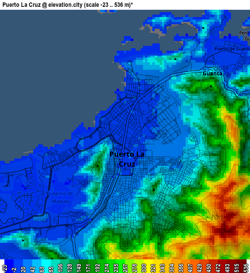
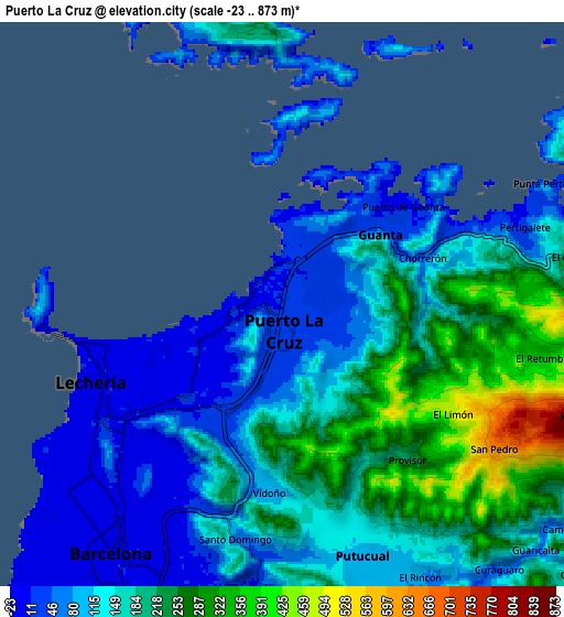
Below is the Elevation map of Puerto La Cruz, which displays elevation range with different colors. Scale of the first map is from -23 to 536 m (-75 to 1759 ft) with average elevation of 101.9 meters (=334 ft) [note 1]
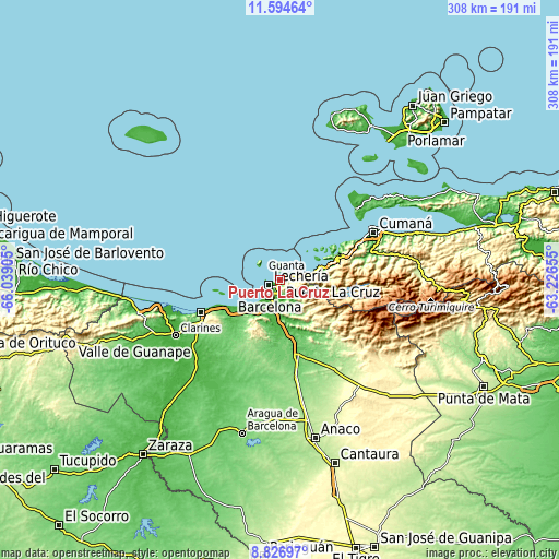
These maps also provides idea of topography and contour of this city, they are displayed at different zoom levels. More info about maps, scale and edge coordinates you can find below images.
| \ | Map #1 | Map #2 | Topo.Map |
| Scale [m] | -23..536 m | -23..873 m | × |
| Scale [ft] | -75..1759 ft | -75..2864 ft | × |
| Average | 101.9 m = 334 ft | 155.3 m = 510 ft | × |
| Width | 9.62 km = 6 mi | 19.24 km = 12 mi | 307.7 km = 191.2 mi |
| Height | 9.62 km = 6 mi | 19.24 km = 12 mi | 307.8 km = 191.3 mi |
| ↑Max Latitude | 10.257066° | 10.300306° | 11.59464° |
| Latitude at center | 10.21382° | 10.21382° | 10.21382° |
| ↓Min Latitude | 10.170568° | 10.12731° | 8.82697° |
| ← Min Longitude | -64.676745° | -64.720691° | -66.03905° |
| Longitude center | -64.6328° | -64.6328° | -64.6328° |
| →Max Longitude | -64.588855° | -64.544909° | -63.22655° |
Nearby cities:
Cities around Puerto La Cruz sort by population:
• Barcelona elevation 8 m
10.4 km,  214°
214°
• Cumaná 4 m
56 km,  61°
61°
• Boca de Uchire 1 m
86.9 km,  263°
263°
• Marigüitar 14 m
84.1 km,  71°
71°
• Cumanacoa 230 m
78.2 km,  87°
87°
• Clarines 29 m
65.8 km,  242°
242°
• Araya 40 m
58 km,  45°
45°
• San Mateo 136 m
53.5 km,  170°
170°
• Píritu 84 m
47.6 km,  245°
245°
• Puerto Píritu 10 m
47.5 km, 248°
• Lecherías 1 m
6.9 km, 249°
• Guanta 27 m
4.5 km, 59°
Multilingual:
 En español:
Puerto de La Cruz elevación 40 m.
 En France:
Puerto La Cruz élévation 40 m.
 Auf Deutsch:
Puerto La Cruz höhe über dem Meeresspiegel ist 40 m.
 На русском:
Пуэрто Ла Круз, Пуэрто-ла-Крус высота над уровнем моря 40 м
Sources and notes:
- [note 1] Map square and city borders are not equal. Map elevation data is calculated only from area inside that square.
- [src 1] Elevation data from geonames database provided with same terms of usage.
- [src 2] The elevation map of Puerto La Cruz is generated using elevation data from NASA's 3 arcsec (90m) resolution SRTM data.
- [src 3] Base (background) map © OpenStreetMap contributors tiles are generated by Geofabrik and OpenTopoMap.
Copyright & License:
This Puerto La Cruz Elevation Map is licensed under CC BY-SA. You may reuse any part from this page, if you give a proper credit by linking to this URL:
 More info on terms of use page.