San Timoteo elevation
San Timoteo (Zulia, Municipio Baralt), Venezuela elevation is 1 meters and San Timoteo elevation in feet is 3 ft above sea level [src 1]. San Timoteo is a seat of a second-order administrative division (feature code) with elevation that is 380 meters (1247 ft) smaller than average city elevation in Venezuela.
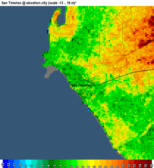
Below is the Elevation map of San Timoteo, which displays elevation range with different colors. Scale of the first map is from -13 to 16 m (-43 to 52 ft) with average elevation of 3 meters (=10 ft) [note 1]
These maps also provides idea of topography and contour of this city, they are displayed at different zoom levels. More info about maps, scale and edge coordinates you can find below images.
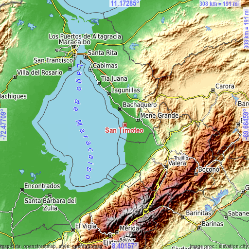
| \ | Map #1 | Topo.Map |
| Scale [m] | -13..16 m | × |
| Scale [ft] | -43..52 ft | × |
| Average | 3 m = 10 ft | × |
| Width | 9.63 km = 6 mi | 308.1 km = 191.4 mi |
| Height | 9.63 km = 6 mi | 308.2 km = 191.5 mi |
| ↑Max Latitude | 9.833403° | 11.17285° |
| Latitude at center | 9.7901° | 9.7901° |
| ↓Min Latitude | 9.746792° | 8.40157° |
| ← Min Longitude | -71.114785° | -72.47709° |
| Longitude center | -71.07084° | -71.07084° |
| →Max Longitude | -71.026895° | -69.66459° |
Nearby cities:
Cities around San Timoteo sort by population:
• Lagunillas elevation -4 m
43.1 km,  331°
331°
• Arapuey 54 m
60.4 km,  167°
167°
• Betijoque 586 m
58.7 km,  140°
140°
• Ciudad Ojeda 1 m
53 km, 329°
• Sabana Grande 191 m
52.5 km,  145°
145°
• Sabana de Mendoza 152 m
51.1 km, 140°
• El Dividive 173 m
50.8 km,  133°
133°
• El Paradero 323 m
49.9 km,  92°
92°
• El Corozo 78 m
36.9 km,  4°
4°
• Santa Apolonia 23 m
36 km, 169°
• Santa Isabel 97 m
33.7 km,  121°
121°
• Bachaquero 0 m
20 km,  343°
343°
Multilingual:
 En español:
San Timoteo elevación 1 m.
 En France:
San Timoteo élévation 1 m.
 Auf Deutsch:
San Timoteo höhe über dem Meeresspiegel ist 1 m.

Sources and notes:
- [note 1] Map square and city borders are not equal. Map elevation data is calculated only from area inside that square.
- [src 1] Elevation data from geonames database provided with same terms of usage.
- [src 2] The elevation map of San Timoteo is generated using elevation data from NASA's 3 arcsec (90m) resolution SRTM data.
- [src 3] Base (background) map © OpenStreetMap contributors tiles are generated by Geofabrik and OpenTopoMap.
Copyright & License:
This San Timoteo Elevation Map is licensed under CC BY-SA. You may reuse any part from this page, if you give a proper credit by linking to this URL:
 More info on terms of use page.