Trujillo elevation
Trujillo, Venezuela elevation is 795 meters and Trujillo elevation in feet is 2608 ft above sea level [src 1]. Trujillo is a seat of a first-order administrative division (feature code) with elevation that is 414 meters (1358 ft) bigger than average city elevation in Venezuela.
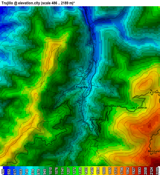
Below is the Elevation map of Trujillo, which displays elevation range with different colors. Scale of the first map is from 486 to 2189 m (1594 to 7182 ft) with average elevation of 1133.6 meters (=3719 ft) [note 1]
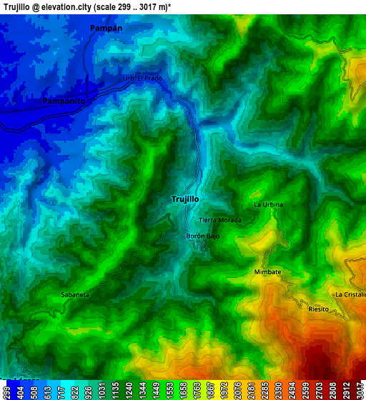
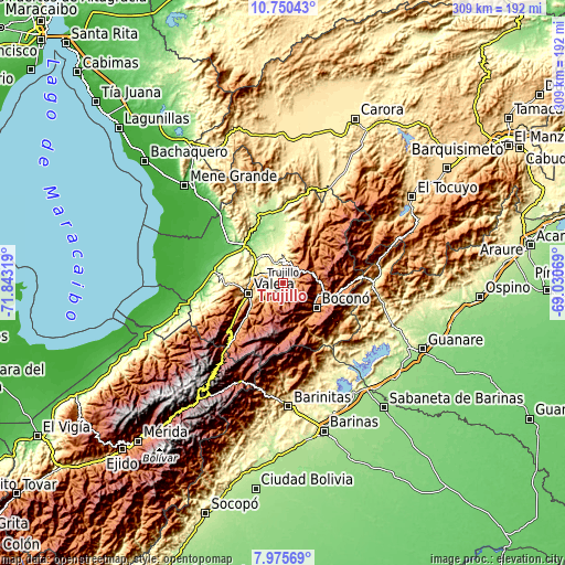
These maps also provides idea of topography and contour of this city, they are displayed at different zoom levels. More info about maps, scale and edge coordinates you can find below images.
| \ | Map #1 | Map #2 | Topo.Map |
| Scale [m] | 486..2189 m | 299..3017 m | × |
| Scale [ft] | 1594..7182 ft | 981..9898 ft | × |
| Average | 1133.6 m = 3719 ft | 1206.9 m = 3960 ft | × |
| Width | 9.64 km = 6 mi | 19.28 km = 12 mi | 308.5 km = 191.7 mi |
| Height | 9.64 km = 6 mi | 19.28 km = 12 mi | 308.6 km = 191.8 mi |
| ↑Max Latitude | 9.409187° | 9.452538° | 10.75043° |
| Latitude at center | 9.36583° | 9.36583° | 9.36583° |
| ↓Min Latitude | 9.322468° | 9.2791° | 7.97569° |
| ← Min Longitude | -70.480885° | -70.524831° | -71.84319° |
| Longitude center | -70.43694° | -70.43694° | -70.43694° |
| →Max Longitude | -70.392995° | -70.349049° | -69.03069° |
Nearby cities:
Cities around Trujillo sort by population:
• Valera elevation 524 m
19.1 km,  253°
253°
• Carache 1210 m
37.1 km,  38°
38°
• El Dividive 173 m
34.9 km,  290°
290°
• Betijoque 586 m
32.5 km,  273°
273°
• Chejendé 986 m
29.4 km,  17°
17°
• La Quebrada 1771 m
28 km,  213°
213°
• Escuque 1019 m
26.9 km, 253°
• Boconó 1421 m
23.9 km,  121°
121°
• Carvajal 799 m
18.1 km, 248°
• Motatán 304 m
17.1 km,  279°
279°
• Pampán 576 m
9.8 km,  334°
334°
• Pampanito 357 m
8.6 km,  305°
305°
Multilingual:
 En español:
Trujillo elevación 795 m.
 En France:
Trujillo élévation 795 m.
 Auf Deutsch:
Trujillo höhe über dem Meeresspiegel ist 795 m.

Sources and notes:
- [note 1] Map square and city borders are not equal. Map elevation data is calculated only from area inside that square.
- [src 1] Elevation data from geonames database provided with same terms of usage.
- [src 2] The elevation map of Trujillo is generated using elevation data from NASA's 3 arcsec (90m) resolution SRTM data.
- [src 3] Base (background) map © OpenStreetMap contributors tiles are generated by Geofabrik and OpenTopoMap.
Copyright & License:
This Trujillo Elevation Map is licensed under CC BY-SA. You may reuse any part from this page, if you give a proper credit by linking to this URL:
 More info on terms of use page.