Yaritagua elevation
Yaritagua (Yaracuy, Municipio Peña), Venezuela elevation is 516 meters and Yaritagua elevation in feet is 1693 ft above sea level [src 1]. Yaritagua is a seat of a second-order administrative division (feature code) with elevation that is 135 meters (443 ft) bigger than average city elevation in Venezuela.
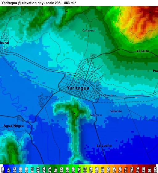
Below is the Elevation map of Yaritagua, which displays elevation range with different colors. Scale of the first map is from 298 to 883 m (978 to 2897 ft) with average elevation of 410.9 meters (=1348 ft) [note 1]
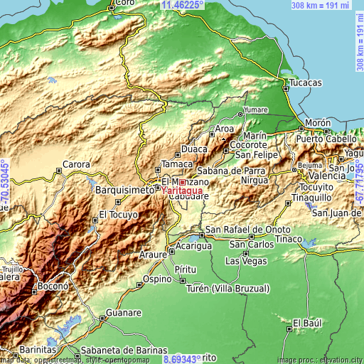
These maps also provides idea of topography and contour of this city, they are displayed at different zoom levels. More info about maps, scale and edge coordinates you can find below images.
| \ | Map #1 | Map #2 | Topo.Map |
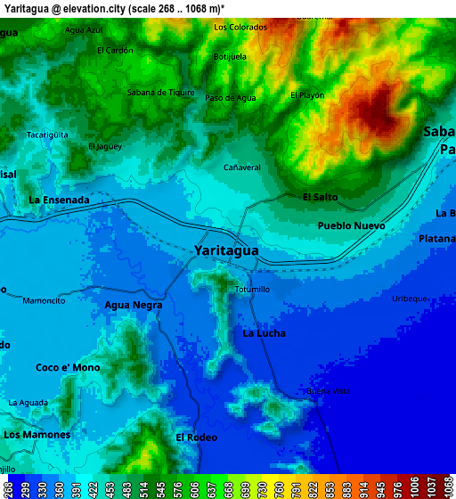
| Scale [m] | 298..883 m | 268..1068 m | × |
| Scale [ft] | 978..2897 ft | 879..3504 ft | × |
| Average | 410.9 m = 1348 ft | 449.5 m = 1475 ft | × |
| Width | 9.62 km = 6 mi | 19.24 km = 12 mi | 307.9 km = 191.3 mi |
| Height | 9.62 km = 6 mi | 19.24 km = 12 mi | 307.9 km = 191.3 mi |
| ↑Max Latitude | 10.124074° | 10.167332° | 11.46225° |
| Latitude at center | 10.08081° | 10.08081° | 10.08081° |
| ↓Min Latitude | 10.03754° | 9.994265° | 8.69343° |
| ← Min Longitude | -69.168145° | -69.212091° | -70.53045° |
| Longitude center | -69.1242° | -69.1242° | -69.1242° |
| →Max Longitude | -69.080255° | -69.036309° | -67.71795° |
Nearby cities:
Cities around Yaritagua sort by population:
• Barquisimeto elevation 606 m
25.6 km,  265°
265°
• Chivacoa 305 m
26.6 km,  70°
70°
• Los Rastrojos 446 m
14.2 km,  244°
244°
• Cocorote 419 m
45.8 km,  54°
54°
• Boraure 188 m
43 km,  64°
64°
• Guama 328 m
39.2 km, 58°
• San Pablo 312 m
35.9 km, 58°
• Sarare 269 m
33.6 km,  187°
187°
• Duaca 733 m
23.1 km,  349°
349°
• Cabudare 505 m
16.3 km,  248°
248°
• Urachiche 569 m
15.4 km, 55°
• Sabana de Parra 416 m
10.6 km, 65°
Multilingual:
 En español:
Yaritagua elevación 516 m.
 En France:
Yaritagua élévation 516 m.
 Auf Deutsch:
Yaritagua höhe über dem Meeresspiegel ist 516 m.

Sources and notes:
- [note 1] Map square and city borders are not equal. Map elevation data is calculated only from area inside that square.
- [src 1] Elevation data from geonames database provided with same terms of usage.
- [src 2] The elevation map of Yaritagua is generated using elevation data from NASA's 3 arcsec (90m) resolution SRTM data.
- [src 3] Base (background) map © OpenStreetMap contributors tiles are generated by Geofabrik and OpenTopoMap.
Copyright & License:
This Yaritagua Elevation Map is licensed under CC BY-SA. You may reuse any part from this page, if you give a proper credit by linking to this URL:
 More info on terms of use page.