Zaraza elevation
Zaraza (Guárico, Municipio Pedro Zaraza), Venezuela elevation is 80 meters and Zaraza elevation in feet is 262 ft above sea level [src 1]. Zaraza is a seat of a second-order administrative division (feature code) with elevation that is 301 meters (988 ft) smaller than average city elevation in Venezuela.
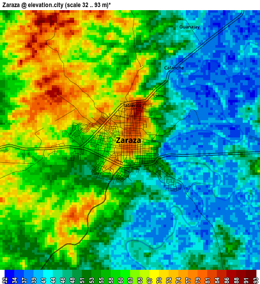
Below is the Elevation map of Zaraza, which displays elevation range with different colors. Scale of the first map is from 32 to 93 m (105 to 305 ft) with average elevation of 54.7 meters (=179 ft) [note 1]
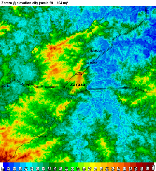
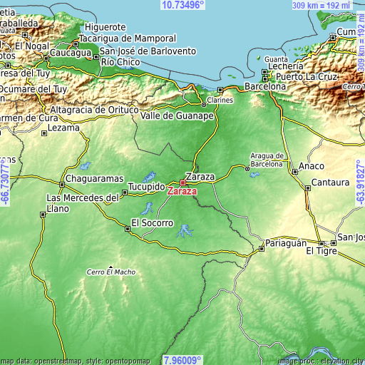
These maps also provides idea of topography and contour of this city, they are displayed at different zoom levels. More info about maps, scale and edge coordinates you can find below images.
| \ | Map #1 | Map #2 | Topo.Map |
| Scale [m] | 32..93 m | 29..104 m | × |
| Scale [ft] | 105..305 ft | 95..341 ft | × |
| Average | 54.7 m = 179 ft | 53.3 m = 175 ft | × |
| Width | 9.64 km = 6 mi | 19.29 km = 12 mi | 308.5 km = 191.7 mi |
| Height | 9.64 km = 6 mi | 19.29 km = 12 mi | 308.6 km = 191.8 mi |
| ↑Max Latitude | 9.393649° | 9.437002° | 10.73496° |
| Latitude at center | 9.35029° | 9.35029° | 9.35029° |
| ↓Min Latitude | 9.306926° | 9.263556° | 7.96009° |
| ← Min Longitude | -65.368465° | -65.412411° | -66.73077° |
| Longitude center | -65.32452° | -65.32452° | -65.32452° |
| →Max Longitude | -65.280575° | -65.236629° | -63.91827° |
Nearby cities:
Cities around Zaraza sort by population:
• Valle de La Pascua elevation 189 m
76.4 km,  258°
258°
• Píritu 84 m
83.1 km,  22°
22°
• San José de Guaribe 227 m
78 km,  316°
316°
• Santa Ana 176 m
73.7 km,  93°
93°
• Valle de Guanape 281 m
73.1 km,  328°
328°
• Clarines 29 m
67.8 km,  14°
14°
• El Socorro 118 m
60.6 km,  229°
229°
• Santa María de Ipire 129 m
59.5 km,  179°
179°
• Aragua de Barcelona 110 m
55.6 km,  77°
77°
• Tucupido 101 m
49.8 km, 260°
• El Chaparro 94 m
40.3 km,  123°
123°
• Onoto 28 m
31 km,  27°
27°
Multilingual:
 En español:
Zaraza elevación 80 m.
 En France:
Zaraza élévation 80 m.


Sources and notes:
- [note 1] Map square and city borders are not equal. Map elevation data is calculated only from area inside that square.
- [src 1] Elevation data from geonames database provided with same terms of usage.
- [src 2] The elevation map of Zaraza is generated using elevation data from NASA's 3 arcsec (90m) resolution SRTM data.
- [src 3] Base (background) map © OpenStreetMap contributors tiles are generated by Geofabrik and OpenTopoMap.
Copyright & License:
This Zaraza Elevation Map is licensed under CC BY-SA. You may reuse any part from this page, if you give a proper credit by linking to this URL:
 More info on terms of use page.