Fergana elevation
Fergana, Uzbekistan elevation is 580 meters and Fergana elevation in feet is 1903 ft above sea level [src 1]. Fergana is a seat of a first-order administrative division (feature code) with elevation that is 151 meters (495 ft) bigger than average city elevation in Uzbekistan.
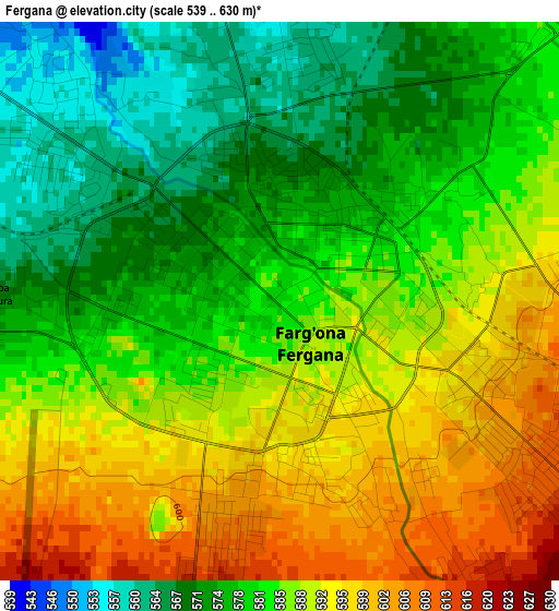
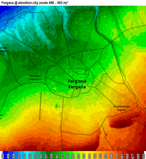
Below is the Elevation map of Fergana, which displays elevation range with different colors. Scale of the first map is from 539 to 630 m (1768 to 2067 ft) with average elevation of 583.7 meters (=1915 ft) [note 1]
These maps also provides idea of topography and contour of this city, they are displayed at different zoom levels. More info about maps, scale and edge coordinates you can find below images.
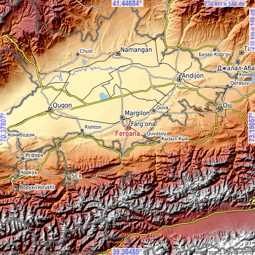
| \ | Map #1 | Map #2 | Topo.Map |
| Scale [m] | 539..630 m | 488..693 m | × |
| Scale [ft] | 1768..2067 ft | 1601..2274 ft | × |
| Average | 583.7 m = 1915 ft | 594.5 m = 1950 ft | × |
| Width | 7.44 km = 4.6 mi | 14.89 km = 9.3 mi | 238.2 km = 148 mi |
| Height | 7.44 km = 4.6 mi | 14.89 km = 9.3 mi | 238.2 km = 148 mi |
| ↑Max Latitude | 40.417676° | 40.451125° | 41.44684° |
| Latitude at center | 40.38421° | 40.38421° | 40.38421° |
| ↓Min Latitude | 40.350728° | 40.317229° | 39.30455° |
| ← Min Longitude | 71.740375° | 71.696429° | 70.37807° |
| Longitude center | 71.78432° | 71.78432° | 71.78432° |
| →Max Longitude | 71.828265° | 71.872211° | 73.19057° |
Nearby cities:
Cities around Fergana sort by population:
• Marg‘ilon elevation 494 m
11 km,  332°
332°
• Quva 496 m
28.8 km,  57°
57°
• Quvasoy 815 m
19.2 km,  120°
120°
• Toshloq 491 m
10.4 km,  352°
352°
• Oltiariq 463 m
26.3 km,  271°
271°
• Kirguli 547 m
5.9 km, 345°
• Yangi Marg‘ilon 534 m
7.3 km,  310°
310°
• Hamza 443 m
24.1 km,  281°
281°
• Oqoltin 405 m
40.9 km, 350°
• Yozyovon 429 m
31 km, 353°
• Vodil 927 m
23.8 km,  191°
191°
• Langar 453 m
18.4 km, 325°
Multilingual:
 En español:
Ferganá elevación 580 m.
 En France:
Ferghana élévation 580 m.
 Auf Deutsch:
Fargʻona höhe über dem Meeresspiegel ist 580 m.

Sources and notes:
- [note 1] Map square and city borders are not equal. Map elevation data is calculated only from area inside that square.
- [src 1] Elevation data from geonames database provided with same terms of usage.
- [src 2] The elevation map of Fergana is generated using elevation data from NASA's 3 arcsec (90m) resolution SRTM data.
- [src 3] Base (background) map © OpenStreetMap contributors tiles are generated by Geofabrik and OpenTopoMap.
Copyright & License:
This Fergana Elevation Map is licensed under CC BY-SA. You may reuse any part from this page, if you give a proper credit by linking to this URL:
 More info on terms of use page.