Gurlan elevation
Gurlan (Xorazm), Uzbekistan elevation is 92 meters and Gurlan elevation in feet is 302 ft above sea level [src 1]. Gurlan is a populated place (feature code) with elevation that is 337 meters (1106 ft) smaller than average city elevation in Uzbekistan.
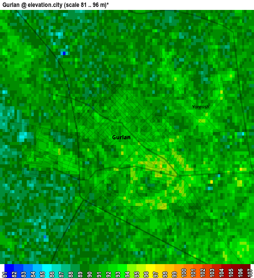
Below is the Elevation map of Gurlan, which displays elevation range with different colors. Scale of the first map is from 81 to 96 m (266 to 315 ft) with average elevation of 90.1 meters (=296 ft) [note 1]
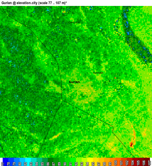
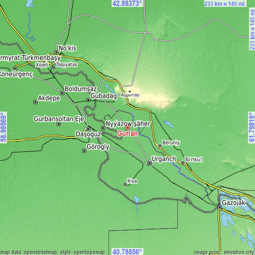
These maps also provides idea of topography and contour of this city, they are displayed at different zoom levels. More info about maps, scale and edge coordinates you can find below images.
| \ | Map #1 | Map #2 | Topo.Map |
| Scale [m] | 81..96 m | 77..107 m | × |
| Scale [ft] | 266..315 ft | 253..351 ft | × |
| Average | 90.1 m = 296 ft | 90 m = 295 ft | × |
| Width | 7.28 km = 4.5 mi | 14.56 km = 9 mi | 233 km = 144.8 mi |
| Height | 7.28 km = 4.5 mi | 14.56 km = 9 mi | 233 km = 144.8 mi |
| ↑Max Latitude | 41.877449° | 41.910161° | 42.88373° |
| Latitude at center | 41.84472° | 41.84472° | 41.84472° |
| ↓Min Latitude | 41.811974° | 41.779212° | 40.78856° |
| ← Min Longitude | 60.347995° | 60.304049° | 58.98569° |
| Longitude center | 60.39194° | 60.39194° | 60.39194° |
| →Max Longitude | 60.435885° | 60.479831° | 61.79819° |
Nearby cities:
Cities around Gurlan sort by population:
• Urganch elevation 105 m
38.4 km,  148°
148°
• Khiwa 98 m
51.9 km,  182°
182°
• Beruniy 101 m
34.4 km,  119°
119°
• Novyy Turtkul’ 106 m
61.4 km, 122°
• Manghit 85 m
40.8 km,  317°
317°
• Showot 97 m
22.3 km,  199°
199°
• Hazorasp 111 m
81.4 km,  135°
135°
• Qŭshkŭpir 97 m
34.7 km,  186°
186°
• To‘rtko‘l Shahri 108 m
59.7 km, 121°
• Bo‘ston Shahri 96 m
46 km,  89°
89°
• Mang‘it Shahri 82 m
41.1 km, 318°
• Beruniy Shahri 99 m
34.2 km, 118°
Multilingual:
 En español:
Gurlan elevación 92 m.
 En France:
Gurlan élévation 92 m.


Sources and notes:
- [note 1] Map square and city borders are not equal. Map elevation data is calculated only from area inside that square.
- [src 1] Elevation data from geonames database provided with same terms of usage.
- [src 2] The elevation map of Gurlan is generated using elevation data from NASA's 3 arcsec (90m) resolution SRTM data.
- [src 3] Base (background) map © OpenStreetMap contributors tiles are generated by Geofabrik and OpenTopoMap.
Copyright & License:
This Gurlan Elevation Map is licensed under CC BY-SA. You may reuse any part from this page, if you give a proper credit by linking to this URL:
 More info on terms of use page.