Iskandar elevation
Iskandar (Toshkent), Uzbekistan elevation is 660 meters and Iskandar elevation in feet is 2165 ft above sea level [src 1]. Iskandar is a populated place (feature code) with elevation that is 231 meters (758 ft) bigger than average city elevation in Uzbekistan.
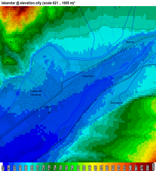
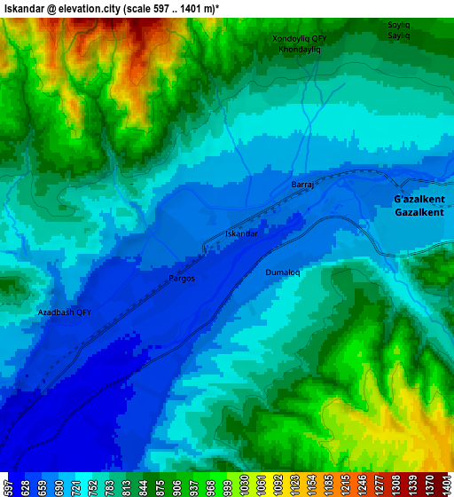
Below is the Elevation map of Iskandar, which displays elevation range with different colors. Scale of the first map is from 621 to 1005 m (2037 to 3297 ft) with average elevation of 699.3 meters (=2294 ft) [note 1]
These maps also provides idea of topography and contour of this city, they are displayed at different zoom levels. More info about maps, scale and edge coordinates you can find below images.
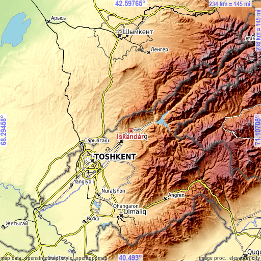
| \ | Map #1 | Map #2 | Topo.Map |
| Scale [m] | 621..1005 m | 597..1401 m | × |
| Scale [ft] | 2037..3297 ft | 1959..4596 ft | × |
| Average | 699.3 m = 2294 ft | 795.8 m = 2611 ft | × |
| Width | 7.31 km = 4.5 mi | 14.63 km = 9.1 mi | 234 km = 145.4 mi |
| Height | 7.31 km = 4.5 mi | 14.63 km = 9.1 mi | 234 km = 145.4 mi |
| ↑Max Latitude | 41.586767° | 41.619628° | 42.59765° |
| Latitude at center | 41.55389° | 41.55389° | 41.55389° |
| ↓Min Latitude | 41.520996° | 41.488085° | 40.493° |
| ← Min Longitude | 69.656885° | 69.612939° | 68.29458° |
| Longitude center | 69.70083° | 69.70083° | 69.70083° |
| →Max Longitude | 69.744775° | 69.788721° | 71.10708° |
Nearby cities:
Cities around Iskandar sort by population:
• Tashkent elevation 424 m
51.6 km,  231°
231°
• Chirchiq 602 m
13.7 km, 226°
• Angren 932 m
70.3 km,  148°
148°
• Parkent 752 m
28.9 km,  184°
184°
• Qibray 534 m
26.8 km, 227°
• Salor 516 m
33.4 km, 232°
• Bektemir 420 m
49 km,  218°
218°
• Yangiobod 1310 m
58.4 km, 145°
• G‘azalkent 702 m
5.8 km,  85°
85°
• Tŭytepa 395 m
64.5 km,  205°
205°
• Ŭrtaowul 386 m
61.8 km, 228°
• Kyzyldzhar 1315 m
26.3 km, 86°
Multilingual:
 En español:
Iskandar elevación 660 m.
 En France:
Iskandar élévation 660 m.
 Auf Deutsch:
Iskandar höhe über dem Meeresspiegel ist 660 m.

Sources and notes:
- [note 1] Map square and city borders are not equal. Map elevation data is calculated only from area inside that square.
- [src 1] Elevation data from geonames database provided with same terms of usage.
- [src 2] The elevation map of Iskandar is generated using elevation data from NASA's 3 arcsec (90m) resolution SRTM data.
- [src 3] Base (background) map © OpenStreetMap contributors tiles are generated by Geofabrik and OpenTopoMap.
Copyright & License:
This Iskandar Elevation Map is licensed under CC BY-SA. You may reuse any part from this page, if you give a proper credit by linking to this URL:
 More info on terms of use page.