Qo‘rg‘ontepa elevation
Qo‘rg‘ontepa (Andijon), Uzbekistan elevation is 709 meters and Qo‘rg‘ontepa elevation in feet is 2326 ft above sea level [src 1]. Qo‘rg‘ontepa is a seat of a second-order administrative division (feature code) with elevation that is 280 meters (919 ft) bigger than average city elevation in Uzbekistan.
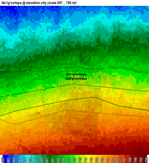
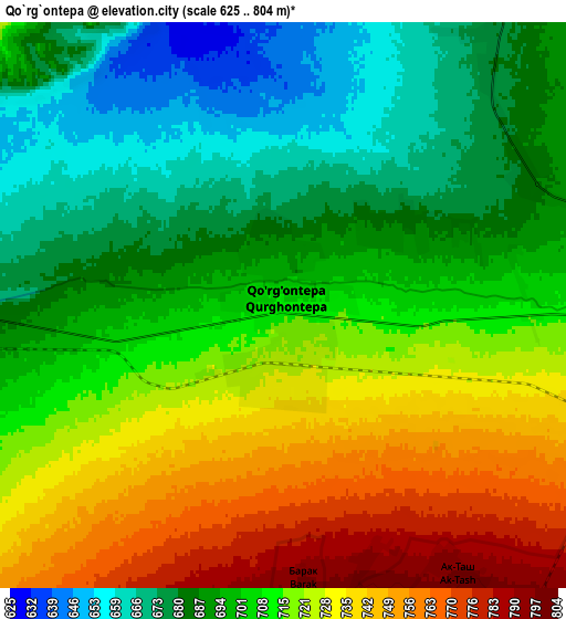
Below is the Elevation map of Qo‘rg‘ontepa, which displays elevation range with different colors. Scale of the first map is from 657 to 756 m (2156 to 2480 ft) with average elevation of 704.9 meters (=2313 ft) [note 1]
These maps also provides idea of topography and contour of this city, they are displayed at different zoom levels. More info about maps, scale and edge coordinates you can find below images.
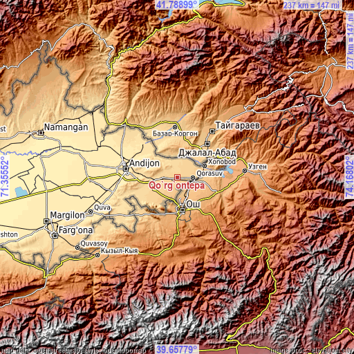
| \ | Map #1 | Map #2 | Topo.Map |
| Scale [m] | 657..756 m | 625..804 m | × |
| Scale [ft] | 2156..2480 ft | 2051..2638 ft | × |
| Average | 704.9 m = 2313 ft | 707.6 m = 2322 ft | × |
| Width | 7.41 km = 4.6 mi | 14.81 km = 9.2 mi | 237 km = 147.3 mi |
| Height | 7.41 km = 4.6 mi | 14.81 km = 9.2 mi | 237 km = 147.3 mi |
| ↑Max Latitude | 40.765212° | 40.798488° | 41.78899° |
| Latitude at center | 40.73192° | 40.73192° | 40.73192° |
| ↓Min Latitude | 40.698611° | 40.665286° | 39.65779° |
| ← Min Longitude | 72.717825° | 72.673879° | 71.35552° |
| Longitude center | 72.76177° | 72.76177° | 72.76177° |
| →Max Longitude | 72.805715° | 72.849661° | 74.16802° |
Nearby cities:
Cities around Qo‘rg‘ontepa sort by population:
• Andijon elevation 494 m
35.6 km,  279°
279°
• Asaka 501 m
45.2 km,  257°
257°
• Haqqulobod 438 m
58 km,  290°
290°
• Xo‘jaobod 669 m
18.4 km,  247°
247°
• Marhamat 627 m
47 km,  233°
233°
• Oltinko‘l 444 m
50.2 km, 278°
• Poytug‘ 460 m
47.2 km, 292°
• Marhamat 607 m
44.7 km,  235°
235°
• Kuyganyor 458 m
40.6 km, 289°
• Paxtaobod 514 m
31.3 km,  314°
314°
• Buloqboshi 649 m
24.7 km, 242°
• Oxunboboyev 682 m
10.1 km, 262°
Multilingual:
 En español:
Qo‘rg‘ontepa elevación 709 m.
 En France:
Qo‘rg‘ontepa élévation 709 m.
 Auf Deutsch:
Qo‘rg‘ontepa höhe über dem Meeresspiegel ist 709 m.

Sources and notes:
- [note 1] Map square and city borders are not equal. Map elevation data is calculated only from area inside that square.
- [src 1] Elevation data from geonames database provided with same terms of usage.
- [src 2] The elevation map of Qo‘rg‘ontepa is generated using elevation data from NASA's 3 arcsec (90m) resolution SRTM data.
- [src 3] Base (background) map © OpenStreetMap contributors tiles are generated by Geofabrik and OpenTopoMap.
Copyright & License:
This Qo‘rg‘ontepa Elevation Map is licensed under CC BY-SA. You may reuse any part from this page, if you give a proper credit by linking to this URL:
 More info on terms of use page.