Yangiqo‘rg‘on elevation
Yangiqo‘rg‘on (Namangan), Uzbekistan elevation is 750 meters and Yangiqo‘rg‘on elevation in feet is 2461 ft above sea level [src 1]. Yangiqo‘rg‘on is a populated place (feature code) with elevation that is 321 meters (1053 ft) bigger than average city elevation in Uzbekistan.
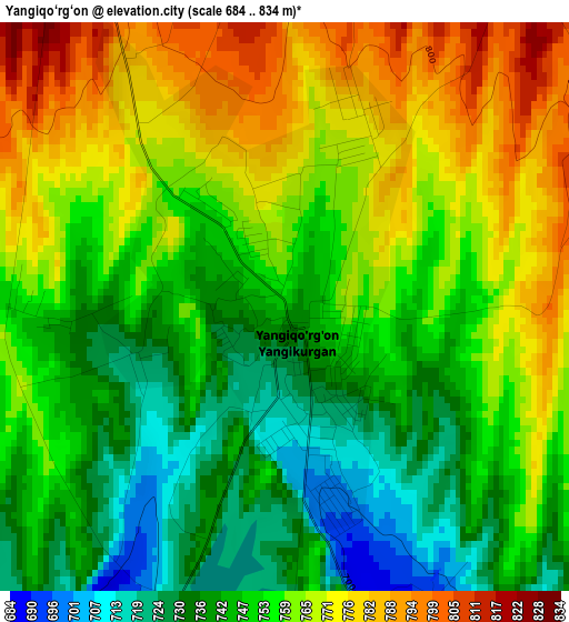
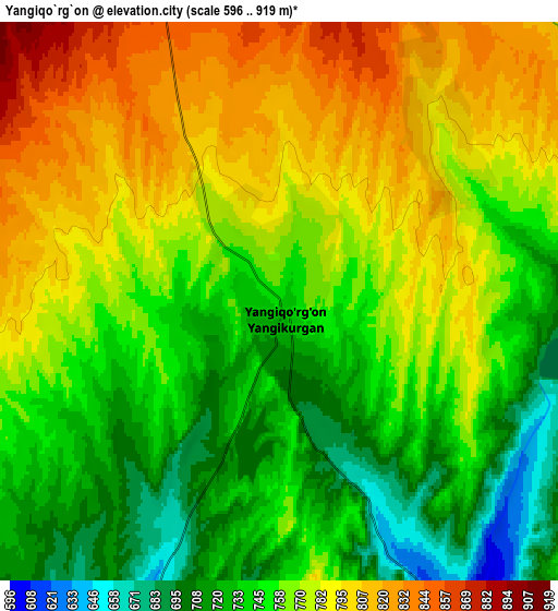
Below is the Elevation map of Yangiqo‘rg‘on, which displays elevation range with different colors. Scale of the first map is from 684 to 834 m (2244 to 2736 ft) with average elevation of 755.5 meters (=2479 ft) [note 1]
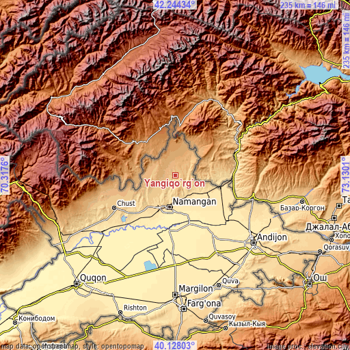
These maps also provides idea of topography and contour of this city, they are displayed at different zoom levels. More info about maps, scale and edge coordinates you can find below images.
| \ | Map #1 | Map #2 | Topo.Map |
| Scale [m] | 684..834 m | 596..919 m | × |
| Scale [ft] | 2244..2736 ft | 1955..3015 ft | × |
| Average | 755.5 m = 2479 ft | 763.4 m = 2505 ft | × |
| Width | 7.35 km = 4.6 mi | 14.71 km = 9.1 mi | 235.3 km = 146.2 mi |
| Height | 7.35 km = 4.6 mi | 14.71 km = 9.1 mi | 235.3 km = 146.2 mi |
| ↑Max Latitude | 41.227799° | 41.260842° | 42.24434° |
| Latitude at center | 41.19474° | 41.19474° | 41.19474° |
| ↓Min Latitude | 41.161664° | 41.128571° | 40.12803° |
| ← Min Longitude | 71.679905° | 71.635959° | 70.3176° |
| Longitude center | 71.72385° | 71.72385° | 71.72385° |
| →Max Longitude | 71.767795° | 71.811741° | 73.1301° |
Nearby cities:
Cities around Yangiqo‘rg‘on sort by population:
• Namangan elevation 442 m
22.3 km,  191°
191°
• Chortoq 520 m
16.3 km,  149°
149°
• Kosonsoy 892 m
16 km,  292°
292°
• Uchqŭrghon Shahri 496 m
31.1 km,  106°
106°
• Uychi 482 m
21 km,  127°
127°
• Toshbuloq 405 m
33.3 km,  201°
201°
• To‘rqao‘rg‘on 556 m
28 km,  219°
219°
• Haqqulobod 438 m
45.2 km, 133°
• Baliqchi 415 m
33.8 km,  162°
162°
• Tŭragŭrghon Shahri 566 m
27.8 km, 220°
• Kosonsoy Shahri 912 m
17 km,  296°
296°
• Chortoq Shahri 536 m
15.3 km, 149°
Multilingual:
 En español:
Yangiqo‘rg‘on elevación 750 m.
 En France:
Yangiqo‘rg‘on élévation 750 m.
 Auf Deutsch:
Yangiqo‘rg‘on höhe über dem Meeresspiegel ist 750 m.

Sources and notes:
- [note 1] Map square and city borders are not equal. Map elevation data is calculated only from area inside that square.
- [src 1] Elevation data from geonames database provided with same terms of usage.
- [src 2] The elevation map of Yangiqo‘rg‘on is generated using elevation data from NASA's 3 arcsec (90m) resolution SRTM data.
- [src 3] Base (background) map © OpenStreetMap contributors tiles are generated by Geofabrik and OpenTopoMap.
Copyright & License:
This Yangiqo‘rg‘on Elevation Map is licensed under CC BY-SA. You may reuse any part from this page, if you give a proper credit by linking to this URL:
 More info on terms of use page.