Kegeyli Shahar elevation
Kegeyli Shahar (Karakalpakstan), Uzbekistan elevation is 68 meters and Kegeyli Shahar elevation in feet is 223 ft above sea level [src 1]. Kegeyli Shahar is a seat of a second-order administrative division (feature code) with elevation that is 361 meters (1184 ft) smaller than average city elevation in Uzbekistan.
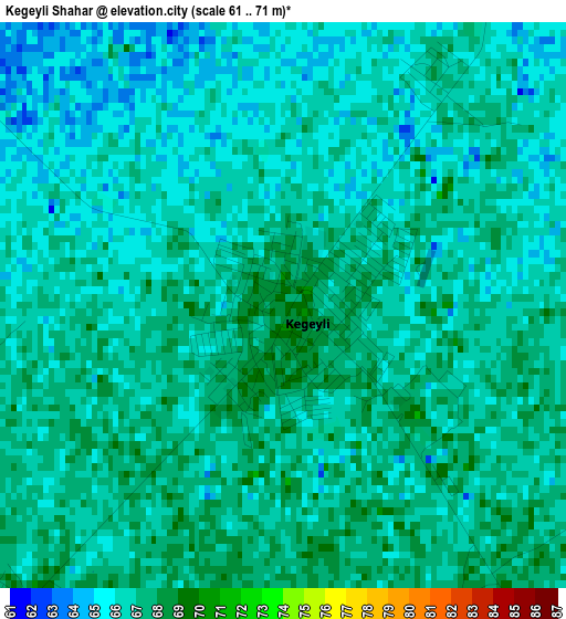
Below is the Elevation map of Kegeyli Shahar, which displays elevation range with different colors. Scale of the first map is from 61 to 71 m (200 to 233 ft) with average elevation of 66.2 meters (=217 ft) [note 1]
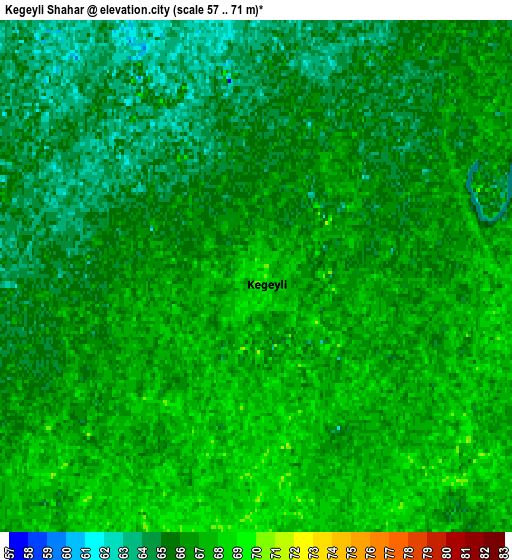
These maps also provides idea of topography and contour of this city, they are displayed at different zoom levels. More info about maps, scale and edge coordinates you can find below images.
| \ | Map #1 | Map #2 | Topo.Map |
| Scale [m] | 61..71 m | 57..71 m | × |
| Scale [ft] | 200..233 ft | 187..233 ft | × |
| Average | 66.2 m = 217 ft | 65.8 m = 216 ft | × |
| Width | 7.17 km = 4.5 mi | 14.35 km = 8.9 mi | 229.5 km = 142.6 mi |
| Height | 7.17 km = 4.5 mi | 14.35 km = 8.9 mi | 229.5 km = 142.6 mi |
| ↑Max Latitude | 42.808918° | 42.841149° | 43.80026° |
| Latitude at center | 42.77667° | 42.77667° | 42.77667° |
| ↓Min Latitude | 42.744405° | 42.712124° | 41.73588° |
| ← Min Longitude | 59.563835° | 59.519889° | 58.20153° |
| Longitude center | 59.60778° | 59.60778° | 59.60778° |
| →Max Longitude | 59.651725° | 59.695671° | 61.01403° |
Nearby cities:
Cities around Kegeyli Shahar sort by population:
• Nukus elevation 76 m
36 km,  179°
179°
• Oltinko‘l 63 m
65.9 km,  299°
299°
• Khŭjayli 76 m
43.5 km,  196°
196°
• Qo‘ng‘irot Shahri 62 m
69.2 km, 296°
• Taxtako‘pir 61 m
62.2 km,  65°
65°
• Shumanay Shahri 68 m
57.5 km,  254°
254°
• Qanliko‘l 68 m
50 km,  278°
278°
• Qorao‘zak 61 m
43.1 km,  50°
50°
• Xo‘jayli Shahri 75 m
43 km, 197°
• Qozonketkan 63 m
33.5 km,  323°
323°
• Chimboy Shahri 65 m
22.1 km,  39°
39°
• Oqmang‘it 71 m
20.7 km, 196°
Multilingual:
 En español:
Kegeyli Shahar elevación 68 m.
 En France:
Kegeyli Shahar élévation 68 m.
 Auf Deutsch:
Kegeyli Shahar höhe über dem Meeresspiegel ist 68 m.

Sources and notes:
- [note 1] Map square and city borders are not equal. Map elevation data is calculated only from area inside that square.
- [src 1] Elevation data from geonames database provided with same terms of usage.
- [src 2] The elevation map of Kegeyli Shahar is generated using elevation data from NASA's 3 arcsec (90m) resolution SRTM data.
- [src 3] Base (background) map © OpenStreetMap contributors tiles are generated by Geofabrik and OpenTopoMap.
Copyright & License:
This Kegeyli Shahar Elevation Map is licensed under CC BY-SA. You may reuse any part from this page, if you give a proper credit by linking to this URL:
 More info on terms of use page.