Libertad elevation
Libertad (San José), Uruguay elevation is 40 meters and Libertad elevation in feet is 131 ft above sea level [src 1]. Libertad is a populated place (feature code) with elevation that is 31 meters (102 ft) smaller than average city elevation in Uruguay.
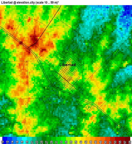
Below is the Elevation map of Libertad, which displays elevation range with different colors. Scale of the first map is from 10 to 59 m (33 to 194 ft) with average elevation of 32.1 meters (=105 ft) [note 1]
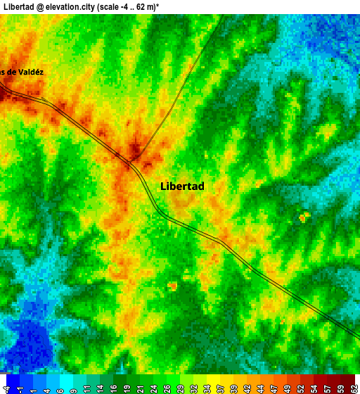
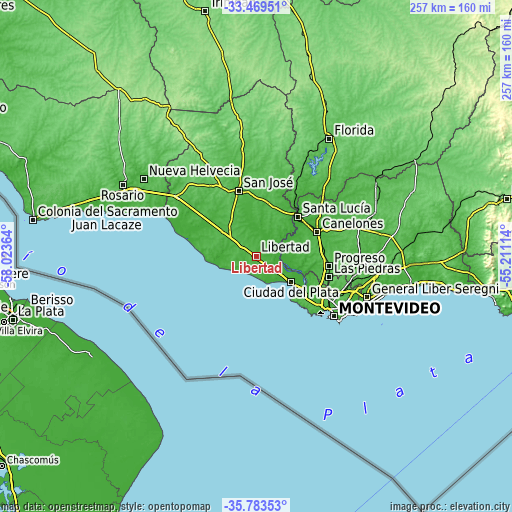
These maps also provides idea of topography and contour of this city, they are displayed at different zoom levels. More info about maps, scale and edge coordinates you can find below images.
| \ | Map #1 | Map #2 | Topo.Map |
| Scale [m] | 10..59 m | -4..62 m | × |
| Scale [ft] | 33..194 ft | -13..203 ft | × |
| Average | 32.1 m = 105 ft | 24.7 m = 81 ft | × |
| Width | 8.04 km = 5 mi | 16.08 km = 10 mi | 257.3 km = 159.9 mi |
| Height | 8.04 km = 5 mi | 16.08 km = 10 mi | 257.3 km = 159.9 mi |
| ↑Max Latitude | -34.598424° | -34.562243° | -33.46951° |
| Latitude at center | -34.63459° | -34.63459° | -34.63459° |
| ↓Min Latitude | -34.67074° | -34.706874° | -35.78353° |
| ← Min Longitude | -56.661335° | -56.705281° | -58.02364° |
| Longitude center | -56.61739° | -56.61739° | -56.61739° |
| →Max Longitude | -56.573445° | -56.529499° | -55.21114° |
Nearby cities:
Cities around Libertad sort by population:
• Canelones elevation 18 m
33.5 km,  68°
68°
• Delta del Tigre 5 m
27.3 km,  122°
122°
• Santa Lucía 24 m
28.9 km,  45°
45°
• Rodríguez 48 m
29.1 km,  14°
14°
• Los Cerrillos 41 m
24.1 km,  82°
82°
• Pajas Blancas 24 m
31.9 km,  125°
125°
• 25 de Agosto 25 m
31.7 km,  38°
38°
• Santiago Vázquez 13 m
29.9 km, 125°
• Juanicó 43 m
33.6 km, 82°
• Puntas de Valdéz 50 m
9.4 km,  305°
305°
• Rafael Perazza 40 m
20.6 km, 306°
• Aguas Corrientes 14 m
24 km,  58°
58°
Multilingual:
 En español:
Libertad elevación 40 m.
 En France:
Libertad élévation 40 m.


Sources and notes:
- [note 1] Map square and city borders are not equal. Map elevation data is calculated only from area inside that square.
- [src 1] Elevation data from geonames database provided with same terms of usage.
- [src 2] The elevation map of Libertad is generated using elevation data from NASA's 3 arcsec (90m) resolution SRTM data.
- [src 3] Base (background) map © OpenStreetMap contributors tiles are generated by Geofabrik and OpenTopoMap.
Copyright & License:
This Libertad Elevation Map is licensed under CC BY-SA. You may reuse any part from this page, if you give a proper credit by linking to this URL:
 More info on terms of use page.