Nueva Palmira elevation
Nueva Palmira (Colonia), Uruguay elevation is 8 meters and Nueva Palmira elevation in feet is 26 ft above sea level [src 1]. Nueva Palmira is a populated place (feature code) with elevation that is 63 meters (207 ft) smaller than average city elevation in Uruguay.
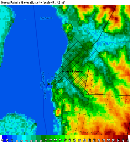
Below is the Elevation map of Nueva Palmira, which displays elevation range with different colors. Scale of the first map is from -5 to 42 m (-16 to 138 ft) with average elevation of 9.4 meters (=31 ft) [note 1]
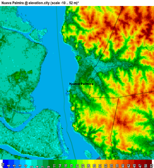
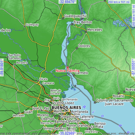
These maps also provides idea of topography and contour of this city, they are displayed at different zoom levels. More info about maps, scale and edge coordinates you can find below images.
| \ | Map #1 | Map #2 | Topo.Map |
| Scale [m] | -5..42 m | -10..52 m | × |
| Scale [ft] | -16..138 ft | -33..171 ft | × |
| Average | 9.4 m = 31 ft | 13.9 m = 46 ft | × |
| Width | 8.11 km = 5 mi | 16.23 km = 10.1 mi | 259.6 km = 161.3 mi |
| Height | 8.11 km = 5 mi | 16.23 km = 10.1 mi | 259.6 km = 161.3 mi |
| ↑Max Latitude | -33.833814° | -33.797303° | -32.69476° |
| Latitude at center | -33.87031° | -33.87031° | -33.87031° |
| ↓Min Latitude | -33.90679° | -33.943254° | -35.02989° |
| ← Min Longitude | -58.455705° | -58.499651° | -59.81801° |
| Longitude center | -58.41176° | -58.41176° | -58.41176° |
| →Max Longitude | -58.367815° | -58.323869° | -57.00551° |
Nearby cities:
Cities around Nueva Palmira sort by population:
• Mercedes elevation 29 m
77.3 km,  27°
27°
• Fray Bentos 17 m
84.3 km,  6°
6°
• Colonia del Sacramento 30 m
84.3 km,  141°
141°
• Carmelo 13 m
18.6 km, 140°
• Dolores 22 m
41.9 km, 25°
• Tarariras 92 m
85.2 km,  121°
121°
• Florencio Sánchez 177 m
96 km,  90°
90°
• Ombúes de Lavalle 110 m
56.1 km,  97°
97°
• José Enrique Rodó 140 m
83.6 km,  76°
76°
• Palmitas 90 m
69.5 km,  54°
54°
• Villa Soriano 5 m
53.2 km, 9°
• Santa Catalina 153 m
85.8 km, 84°
Multilingual:
 En español:
Nueva Palmira elevación 8 m.
 En France:
Nueva Palmira élévation 8 m.
 Auf Deutsch:
Nueva Palmira höhe über dem Meeresspiegel ist 8 m.

Sources and notes:
- [note 1] Map square and city borders are not equal. Map elevation data is calculated only from area inside that square.
- [src 1] Elevation data from geonames database provided with same terms of usage.
- [src 2] The elevation map of Nueva Palmira is generated using elevation data from NASA's 3 arcsec (90m) resolution SRTM data.
- [src 3] Base (background) map © OpenStreetMap contributors tiles are generated by Geofabrik and OpenTopoMap.
Copyright & License:
This Nueva Palmira Elevation Map is licensed under CC BY-SA. You may reuse any part from this page, if you give a proper credit by linking to this URL:
 More info on terms of use page.