Donskoye elevation
Donskoye (Republic of Crimea, Simferopol Raion), Ukraine elevation is 271 meters and Donskoye elevation in feet is 889 ft above sea level [src 1]. Donskoye is a seat of a third-order administrative division (feature code) with elevation that is 114 meters (374 ft) bigger than average city elevation in Ukraine.
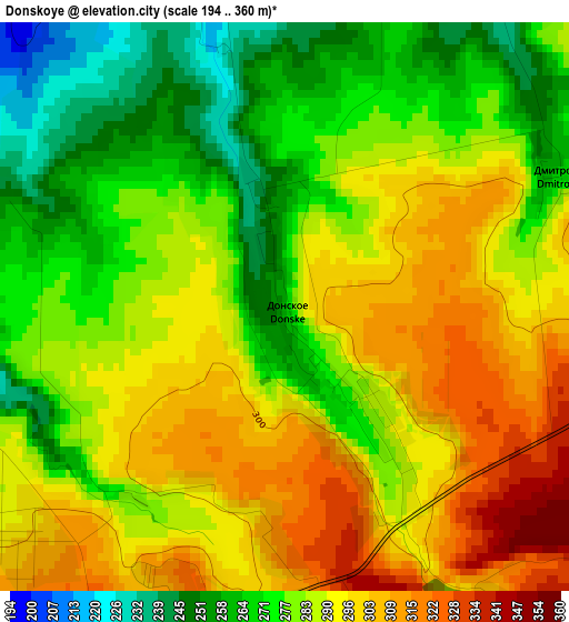
Below is the Elevation map of Donskoye, which displays elevation range with different colors. Scale of the first map is from 194 to 360 m (636 to 1181 ft) with average elevation of 284.9 meters (=935 ft) [note 1]
These maps also provides idea of topography and contour of this city, they are displayed at different zoom levels. More info about maps, scale and edge coordinates you can find below images.
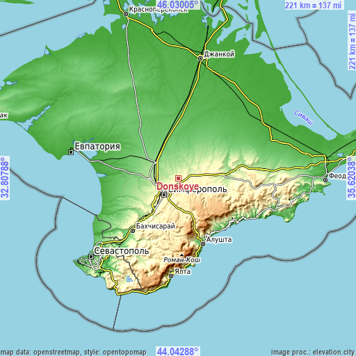
| \ | Map #1 | Topo.Map |
| Scale [m] | 194..360 m | × |
| Scale [ft] | 636..1181 ft | × |
| Average | 284.9 m = 935 ft | × |
| Width | 6.9 km = 4.3 mi | 221 km = 137.3 mi |
| Height | 6.9 km = 4.3 mi | 220.9 km = 137.3 mi |
| ↑Max Latitude | 45.076131° | 46.03005° |
| Latitude at center | 45.04509° | 45.04509° |
| ↓Min Latitude | 45.014032° | 44.04288° |
| ← Min Longitude | 34.170185° | 32.80788° |
| Longitude center | 34.21413° | 34.21413° |
| →Max Longitude | 34.258075° | 35.62038° |
Nearby cities:
Cities around Donskoye sort by population:
• Simferopol elevation 247 m
12.7 km,  219°
219°
• Zuya 253 m
8.5 km,  83°
83°
• Agrarnoye 237 m
12.7 km,  255°
255°
• Urozhaynoye 203 m
6.2 km,  270°
270°
• Strogonovka 309 m
11 km,  194°
194°
• Mazanka 337 m
5.5 km,  143°
143°
• Trudovoye 381 m
6 km, 188°
• Krymskaya Roza 293 m
11.3 km, 82°
• Novozhilovka 149 m
12.8 km,  6°
6°
• Litvinenkovo 218 m
8.9 km,  58°
58°
• Chaykino 166 m
10.8 km,  292°
292°
• Solnechnoye 182 m
10.2 km, 271°
Multilingual:
 En español:
Donskoye elevación 271 m.
 En France:
Donskoye élévation 271 m.
 Auf Deutsch:
Donskoye höhe über dem Meeresspiegel ist 271 m.

Sources and notes:
- [note 1] Map square and city borders are not equal. Map elevation data is calculated only from area inside that square.
- [src 1] Elevation data from geonames database provided with same terms of usage.
- [src 2] The elevation map of Donskoye is generated using elevation data from NASA's 3 arcsec (90m) resolution SRTM data.
- [src 3] Base (background) map © OpenStreetMap contributors tiles are generated by Geofabrik and OpenTopoMap.
Copyright & License:
This Donskoye Elevation Map is licensed under CC BY-SA. You may reuse any part from this page, if you give a proper credit by linking to this URL:
 More info on terms of use page.