Chynadiyovo elevation
Chynadiyovo (Transcarpathia), Ukraine elevation is 144 meters and Chynadiyovo elevation in feet is 472 ft above sea level [src 1]. Chynadiyovo is a populated place (feature code) with elevation that is 13 meters (43 ft) smaller than average city elevation in Ukraine.
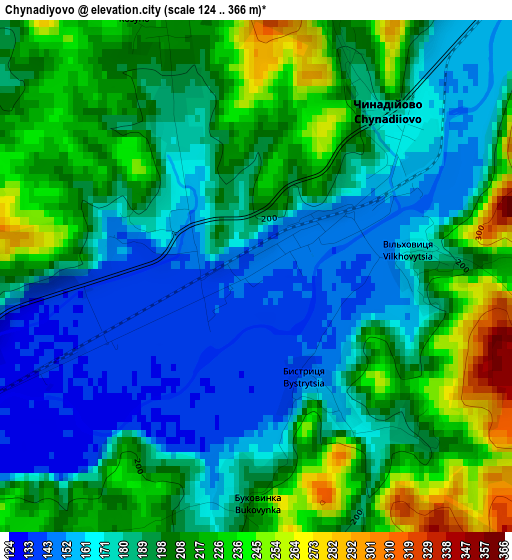
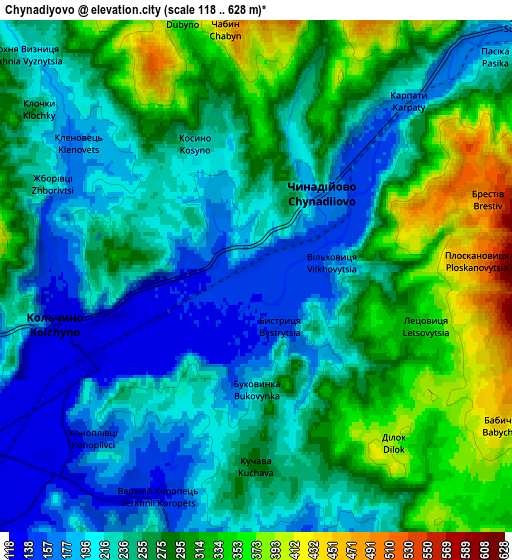
Below is the Elevation map of Chynadiyovo, which displays elevation range with different colors. Scale of the first map is from 124 to 366 m (407 to 1201 ft) with average elevation of 193 meters (=633 ft) [note 1]
These maps also provides idea of topography and contour of this city, they are displayed at different zoom levels. More info about maps, scale and edge coordinates you can find below images.
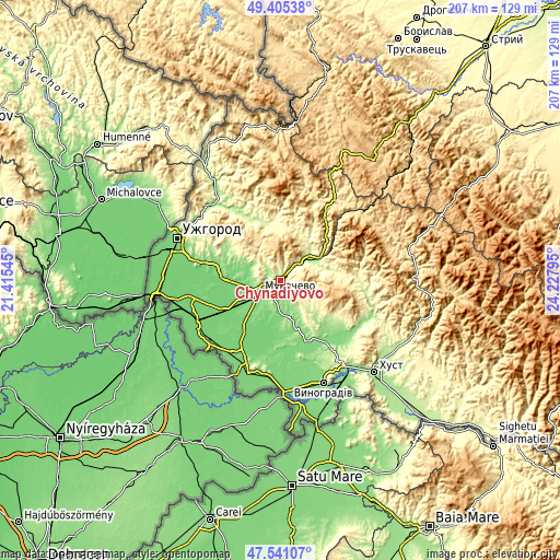
| \ | Map #1 | Map #2 | Topo.Map |
| Scale [m] | 124..366 m | 118..628 m | × |
| Scale [ft] | 407..1201 ft | 387..2060 ft | × |
| Average | 193 m = 633 ft | 258.6 m = 848 ft | × |
| Width | 6.48 km = 4 mi | 12.96 km = 8.1 mi | 207.3 km = 128.8 mi |
| Height | 6.48 km = 4 mi | 12.96 km = 8.1 mi | 207.3 km = 128.8 mi |
| ↑Max Latitude | 48.510911° | 48.540016° | 49.40538° |
| Latitude at center | 48.48179° | 48.48179° | 48.48179° |
| ↓Min Latitude | 48.452652° | 48.423498° | 47.54107° |
| ← Min Longitude | 22.777755° | 22.733809° | 21.41545° |
| Longitude center | 22.8217° | 22.8217° | 22.8217° |
| →Max Longitude | 22.865645° | 22.909591° | 24.22795° |
Nearby cities:
Cities around Chynadiyovo sort by population:
• Mukacheve elevation 126 m
9 km,  238°
238°
• Svalyava 208 m
14.8 km,  59°
59°
• Irshava 140 m
24.4 km,  138°
138°
• Bilky 147 m
29.5 km,  128°
128°
• Nove Davydkovo 115 m
15.4 km,  253°
253°
• Poroshkovo 241 m
21.3 km,  346°
346°
• Serednye 125 m
24.1 km,  285°
285°
• Nelipyno 219 m
17.8 km, 60°
• Strabychovo 106 m
22.8 km, 244°
• Rakoshyno 115 m
16.7 km,  264°
264°
• Bereznyky 313 m
29.6 km,  83°
83°
• Velyki Berehy 117 m
28.3 km,  191°
191°
Multilingual:
 En español:
Chynadiyovo elevación 144 m.
 En France:
Chynadiyovo élévation 144 m.
 Auf Deutsch:
Chynadiyovo höhe über dem Meeresspiegel ist 144 m.

Sources and notes:
- [note 1] Map square and city borders are not equal. Map elevation data is calculated only from area inside that square.
- [src 1] Elevation data from geonames database provided with same terms of usage.
- [src 2] The elevation map of Chynadiyovo is generated using elevation data from NASA's 3 arcsec (90m) resolution SRTM data.
- [src 3] Base (background) map © OpenStreetMap contributors tiles are generated by Geofabrik and OpenTopoMap.
Copyright & License:
This Chynadiyovo Elevation Map is licensed under CC BY-SA. You may reuse any part from this page, if you give a proper credit by linking to this URL:
 More info on terms of use page.