Chop elevation
Chop (Transcarpathia), Ukraine elevation is 105 meters and Chop elevation in feet is 344 ft above sea level [src 1]. Chop is a populated place (feature code) with elevation that is 52 meters (171 ft) smaller than average city elevation in Ukraine.
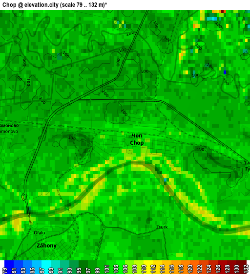
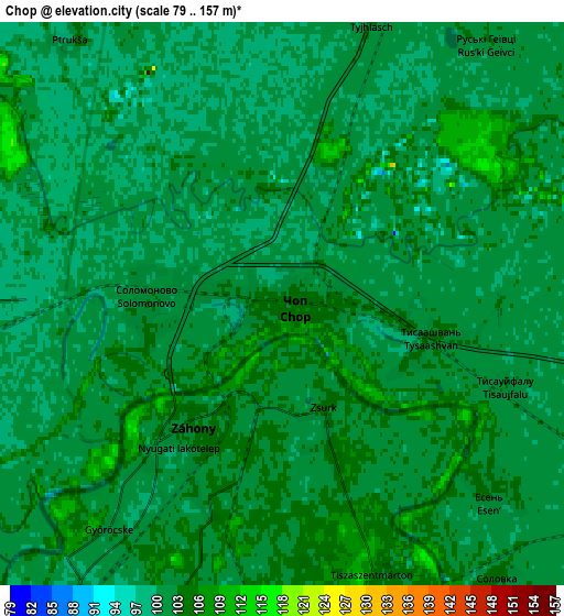
Below is the Elevation map of Chop, which displays elevation range with different colors. Scale of the first map is from 79 to 132 m (259 to 433 ft) with average elevation of 101.8 meters (=334 ft) [note 1]
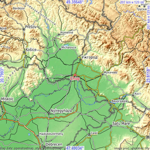
These maps also provides idea of topography and contour of this city, they are displayed at different zoom levels. More info about maps, scale and edge coordinates you can find below images.
| \ | Map #1 | Map #2 | Topo.Map |
| Scale [m] | 79..132 m | 79..157 m | × |
| Scale [ft] | 259..433 ft | 259..515 ft | × |
| Average | 101.8 m = 334 ft | 101.5 m = 333 ft | × |
| Width | 6.48 km = 4 mi | 12.97 km = 8.1 mi | 207.5 km = 128.9 mi |
| Height | 6.48 km = 4 mi | 12.97 km = 8.1 mi | 207.5 km = 128.9 mi |
| ↑Max Latitude | 48.46113° | 48.490263° | 49.35648° |
| Latitude at center | 48.43198° | 48.43198° | 48.43198° |
| ↓Min Latitude | 48.402814° | 48.37363° | 47.49034° |
| ← Min Longitude | 22.161605° | 22.117659° | 20.7993° |
| Longitude center | 22.20555° | 22.20555° | 22.20555° |
| →Max Longitude | 22.249495° | 22.293441° | 23.6118° |
Nearby cities:
Cities around Chop sort by population:
• Uzhgorod elevation 119 m
21.7 km,  18°
18°
• Nove Davydkovo 115 m
30.7 km,  88°
88°
• Serednye 125 m
25.3 km,  61°
61°
• Strabychovo 106 m
25.3 km,  100°
100°
• Rakoshyno 115 m
29.1 km,  82°
82°
• Batiovo 106 m
16.3 km,  118°
118°
• Mynay 111 m
18.2 km, 16°
• Storozhnytsya 110 m
19.2 km,  5°
5°
• Koson’ 106 m
27 km,  136°
136°
• Onokivtsi 127 m
27 km, 21°
• Kamianytsia 166 m
32.3 km,  25°
25°
• Nevyts’ke 130 m
30.2 km, 26°
Multilingual:
 En español:
Chop elevación 105 m.
 En France:
Chop élévation 105 m.


Sources and notes:
- [note 1] Map square and city borders are not equal. Map elevation data is calculated only from area inside that square.
- [src 1] Elevation data from geonames database provided with same terms of usage.
- [src 2] The elevation map of Chop is generated using elevation data from NASA's 3 arcsec (90m) resolution SRTM data.
- [src 3] Base (background) map © OpenStreetMap contributors tiles are generated by Geofabrik and OpenTopoMap.
Copyright & License:
This Chop Elevation Map is licensed under CC BY-SA. You may reuse any part from this page, if you give a proper credit by linking to this URL:
 More info on terms of use page.