Dniprovka elevation
Dniprovka (Zaporizhia), Ukraine elevation is 22 meters and Dniprovka elevation in feet is 72 ft above sea level [src 1]. Dniprovka is a populated place (feature code) with elevation that is 135 meters (443 ft) smaller than average city elevation in Ukraine.
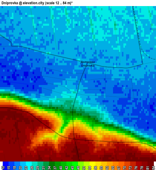
Below is the Elevation map of Dniprovka, which displays elevation range with different colors. Scale of the first map is from 12 to 84 m (39 to 276 ft) with average elevation of 35.4 meters (=116 ft) [note 1]
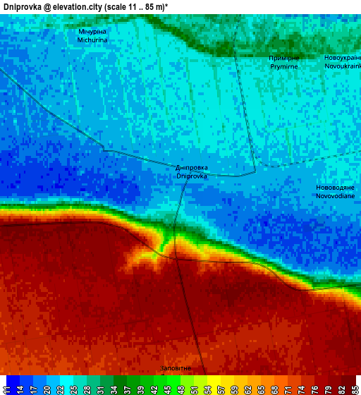
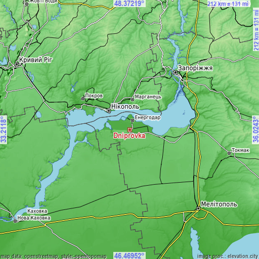
These maps also provides idea of topography and contour of this city, they are displayed at different zoom levels. More info about maps, scale and edge coordinates you can find below images.
| \ | Map #1 | Map #2 | Topo.Map |
| Scale [m] | 12..84 m | 11..85 m | × |
| Scale [ft] | 39..276 ft | 36..279 ft | × |
| Average | 35.4 m = 116 ft | 42.4 m = 139 ft | × |
| Width | 6.61 km = 4.1 mi | 13.22 km = 8.2 mi | 211.6 km = 131.5 mi |
| Height | 6.61 km = 4.1 mi | 13.22 km = 8.2 mi | 211.5 km = 131.4 mi |
| ↑Max Latitude | 47.45917° | 47.488874° | 48.37219° |
| Latitude at center | 47.42945° | 47.42945° | 47.42945° |
| ↓Min Latitude | 47.399713° | 47.369959° | 46.46952° |
| ← Min Longitude | 34.574105° | 34.530159° | 33.2118° |
| Longitude center | 34.61805° | 34.61805° | 34.61805° |
| →Max Longitude | 34.661995° | 34.705941° | 36.0243° |
Nearby cities:
Cities around Dniprovka sort by population:
• Nikopol elevation 67 m
22.9 km,  313°
313°
• Energodar 29 m
8.2 km,  21°
21°
• Marhanets’ 75 m
22.9 km,  1°
1°
• Dniprorudne 67 m
27.5 km,  101°
101°
• Verkhniy Rohachyk 54 m
29 km,  226°
226°
• Chervonohryhorivka 23 m
22.3 km,  344°
344°
• Balky 73 m
25.1 km, 101°
• Vodyane 20 m
11.4 km,  304°
304°
• Vil’ne 83 m
27.3 km,  32°
32°
• Vyshchetarasivka 31 m
25.1 km,  51°
51°
• Velyka Bilozerka 42 m
18.1 km,  158°
158°
• Kamenka-Na-Dnepre 18 m
16.7 km,  291°
291°
Multilingual:
 En español:
Dniprovka elevación 22 m.
 En France:
Dniprovka élévation 22 m.
 Auf Deutsch:
Dniprovka höhe über dem Meeresspiegel ist 22 m.

Sources and notes:
- [note 1] Map square and city borders are not equal. Map elevation data is calculated only from area inside that square.
- [src 1] Elevation data from geonames database provided with same terms of usage.
- [src 2] The elevation map of Dniprovka is generated using elevation data from NASA's 3 arcsec (90m) resolution SRTM data.
- [src 3] Base (background) map © OpenStreetMap contributors tiles are generated by Geofabrik and OpenTopoMap.
Copyright & License:
This Dniprovka Elevation Map is licensed under CC BY-SA. You may reuse any part from this page, if you give a proper credit by linking to this URL:
 More info on terms of use page.