Dovhe elevation
Dovhe (Transcarpathia), Ukraine elevation is 172 meters and Dovhe elevation in feet is 564 ft above sea level [src 1]. Dovhe is a populated place (feature code) with elevation that is 15 meters (49 ft) bigger than average city elevation in Ukraine.
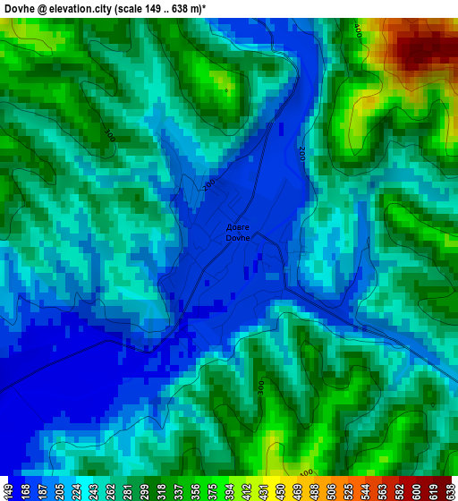
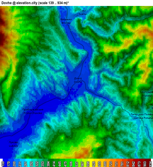
Below is the Elevation map of Dovhe, which displays elevation range with different colors. Scale of the first map is from 149 to 638 m (489 to 2093 ft) with average elevation of 260.2 meters (=854 ft) [note 1]
These maps also provides idea of topography and contour of this city, they are displayed at different zoom levels. More info about maps, scale and edge coordinates you can find below images.
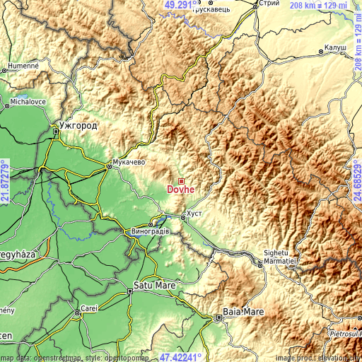
| \ | Map #1 | Map #2 | Topo.Map |
| Scale [m] | 149..638 m | 139..934 m | × |
| Scale [ft] | 489..2093 ft | 456..3064 ft | × |
| Average | 260.2 m = 854 ft | 360.4 m = 1182 ft | × |
| Width | 6.49 km = 4 mi | 12.99 km = 8.1 mi | 207.8 km = 129.1 mi |
| Height | 6.49 km = 4 mi | 12.99 km = 8.1 mi | 207.8 km = 129.1 mi |
| ↑Max Latitude | 48.394458° | 48.423629° | 49.291° |
| Latitude at center | 48.36527° | 48.36527° | 48.36527° |
| ↓Min Latitude | 48.336065° | 48.306844° | 47.42241° |
| ← Min Longitude | 23.235095° | 23.191149° | 21.87279° |
| Longitude center | 23.27904° | 23.27904° | 23.27904° |
| →Max Longitude | 23.322985° | 23.366931° | 24.68529° |
Nearby cities:
Cities around Dovhe sort by population:
• Khust elevation 169 m
20.7 km,  175°
175°
• Irshava 140 m
18.6 km,  253°
253°
• Bilky 147 m
12.2 km,  242°
242°
• Iza 183 m
17.1 km,  167°
167°
• Rokosovo 177 m
18.8 km,  203°
203°
• Kushnytsya 227 m
8.4 km,  349°
349°
• Lypcha 207 m
13.9 km,  146°
146°
• Lysychovo 337 m
14.6 km,  3°
3°
• Bereznyky 313 m
17.1 km, 345°
• Horinchovo 227 m
15.6 km,  132°
132°
• Kryva 163 m
21.7 km,  188°
188°
• Berezovo 276 m
15.7 km,  113°
113°
Multilingual:
 En español:
Dovhe elevación 172 m.
 En France:
Dovhe élévation 172 m.


Sources and notes:
- [note 1] Map square and city borders are not equal. Map elevation data is calculated only from area inside that square.
- [src 1] Elevation data from geonames database provided with same terms of usage.
- [src 2] The elevation map of Dovhe is generated using elevation data from NASA's 3 arcsec (90m) resolution SRTM data.
- [src 3] Base (background) map © OpenStreetMap contributors tiles are generated by Geofabrik and OpenTopoMap.
Copyright & License:
This Dovhe Elevation Map is licensed under CC BY-SA. You may reuse any part from this page, if you give a proper credit by linking to this URL:
 More info on terms of use page.