Dunayivtsi elevation
Dunayivtsi (Khmelnytskyi), Ukraine elevation is 295 meters and Dunayivtsi elevation in feet is 968 ft above sea level [src 1]. Dunayivtsi is a seat of a second-order administrative division (feature code) with elevation that is 138 meters (453 ft) bigger than average city elevation in Ukraine.
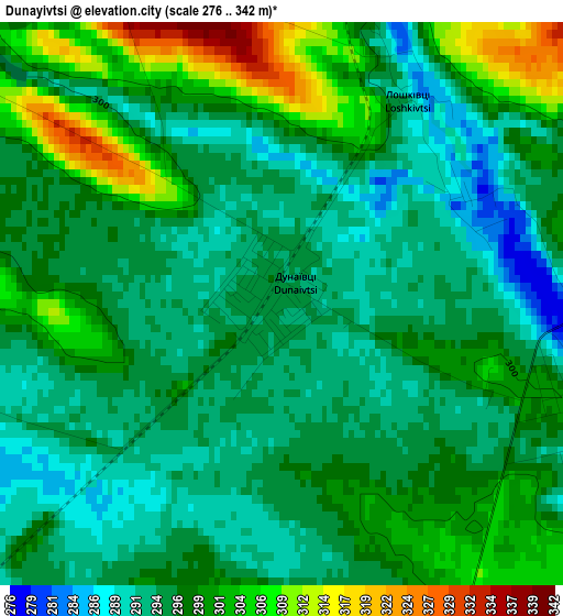
Below is the Elevation map of Dunayivtsi, which displays elevation range with different colors. Scale of the first map is from 276 to 342 m (906 to 1122 ft) with average elevation of 297.1 meters (=975 ft) [note 1]
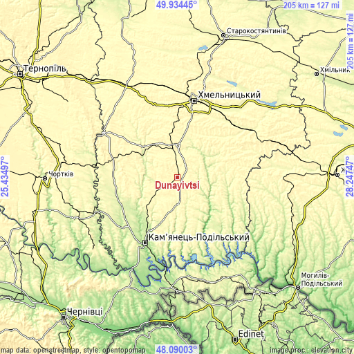
These maps also provides idea of topography and contour of this city, they are displayed at different zoom levels. More info about maps, scale and edge coordinates you can find below images.
| \ | Map #1 | Topo.Map |
| Scale [m] | 276..342 m | × |
| Scale [ft] | 906..1122 ft | × |
| Average | 297.1 m = 975 ft | × |
| Width | 6.41 km = 4 mi | 205.1 km = 127.4 mi |
| Height | 6.41 km = 4 mi | 205.1 km = 127.4 mi |
| ↑Max Latitude | 49.04959° | 49.93445° |
| Latitude at center | 49.02078° | 49.02078° |
| ↓Min Latitude | 48.991953° | 48.09003° |
| ← Min Longitude | 26.797275° | 25.43497° |
| Longitude center | 26.84122° | 26.84122° |
| →Max Longitude | 26.885165° | 28.24747° |
Nearby cities:
Cities around Dunayivtsi sort by population:
• Khmelnytskyi elevation 286 m
46 km,  14°
14°
• Kamianets-Podilskyi 227 m
41.8 km,  206°
206°
• Horodok 256 m
24.6 km,  310°
310°
• Dunaivtsi 320 m
14.7 km,  175°
175°
• Yarmolyntsi 341 m
19.1 km,  359°
359°
• Makiv 266 m
27.4 km,  203°
203°
• Nova Ushytsya 249 m
37.7 km,  122°
122°
• Zakupne 322 m
38.3 km,  286°
286°
• Husiatyn 268 m
45.4 km,  276°
276°
• Smotrych 213 m
44.9 km, 207°
• Chemerivtsi 285 m
36.4 km,  268°
268°
• Vinkivtsi 314 m
28.8 km,  86°
86°
Multilingual:
 En español:
Dunayivtsi elevación 295 m.
 En France:
Dunayivtsi élévation 295 m.
 Auf Deutsch:
Dunayivtsi höhe über dem Meeresspiegel ist 295 m.

Sources and notes:
- [note 1] Map square and city borders are not equal. Map elevation data is calculated only from area inside that square.
- [src 1] Elevation data from geonames database provided with same terms of usage.
- [src 2] The elevation map of Dunayivtsi is generated using elevation data from NASA's 3 arcsec (90m) resolution SRTM data.
- [src 3] Base (background) map © OpenStreetMap contributors tiles are generated by Geofabrik and OpenTopoMap.
Copyright & License:
This Dunayivtsi Elevation Map is licensed under CC BY-SA. You may reuse any part from this page, if you give a proper credit by linking to this URL:
 More info on terms of use page.