Horodnya elevation
Horodnya (Chernihiv), Ukraine elevation is 137 meters and Horodnya elevation in feet is 449 ft above sea level [src 1]. Horodnya is a seat of a second-order administrative division (feature code) with elevation that is 20 meters (66 ft) smaller than average city elevation in Ukraine.
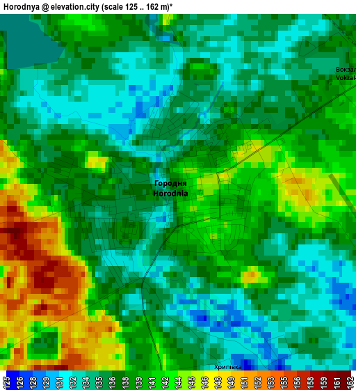
Below is the Elevation map of Horodnya, which displays elevation range with different colors. Scale of the first map is from 125 to 162 m (410 to 531 ft) with average elevation of 138.1 meters (=453 ft) [note 1]
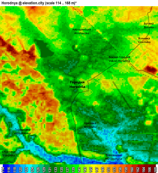
These maps also provides idea of topography and contour of this city, they are displayed at different zoom levels. More info about maps, scale and edge coordinates you can find below images.
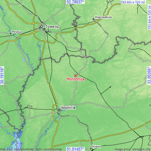
| \ | Map #1 | Map #2 | Topo.Map |
| Scale [m] | 125..162 m | 114..168 m | × |
| Scale [ft] | 410..531 ft | 374..551 ft | × |
| Average | 138.1 m = 453 ft | 139.6 m = 458 ft | × |
| Width | 6.03 km = 3.7 mi | 12.06 km = 7.5 mi | 193 km = 119.9 mi |
| Height | 6.03 km = 3.7 mi | 12.06 km = 7.5 mi | 193 km = 119.9 mi |
| ↑Max Latitude | 51.917963° | 51.94506° | 52.75037° |
| Latitude at center | 51.89085° | 51.89085° | 51.89085° |
| ↓Min Latitude | 51.86372° | 51.836575° | 51.01457° |
| ← Min Longitude | 31.553465° | 31.509519° | 30.19116° |
| Longitude center | 31.59741° | 31.59741° | 31.59741° |
| →Max Longitude | 31.641355° | 31.685301° | 33.00366° |
Nearby cities:
Cities around Horodnya sort by population:
• Chernihiv elevation 127 m
48 km,  206°
206°
• Slavutych 131 m
73.1 km,  235°
235°
• Koryukivka 130 m
46.7 km,  106°
106°
• Mena 129 m
59.2 km,  133°
133°
• Shchors 125 m
25.2 km, 108°
• Ripky 145 m
36.7 km,  254°
254°
• Kulykivka 119 m
57.6 km,  176°
176°
• Berezna 129 m
37.8 km,  160°
160°
• Dobryanka 145 m
34.1 km,  304°
304°
• Kholmy 156 m
68.9 km,  91°
91°
• Lyubech 151 m
68 km, 252°
• Sedniv 138 m
27.5 km, 184°
Multilingual:
 En español:
Horodnya elevación 137 m.
 En France:
Horodnya élévation 137 m.
 Auf Deutsch:
Horodnya höhe über dem Meeresspiegel ist 137 m.

Sources and notes:
- [note 1] Map square and city borders are not equal. Map elevation data is calculated only from area inside that square.
- [src 1] Elevation data from geonames database provided with same terms of usage.
- [src 2] The elevation map of Horodnya is generated using elevation data from NASA's 3 arcsec (90m) resolution SRTM data.
- [src 3] Base (background) map © OpenStreetMap contributors tiles are generated by Geofabrik and OpenTopoMap.
Copyright & License:
This Horodnya Elevation Map is licensed under CC BY-SA. You may reuse any part from this page, if you give a proper credit by linking to this URL:
 More info on terms of use page.