Hostomel elevation
Hostomel (Kyiv), Ukraine elevation is 109 meters and Hostomel elevation in feet is 358 ft above sea level [src 1]. Hostomel is a populated place (feature code) with elevation that is 48 meters (157 ft) smaller than average city elevation in Ukraine.
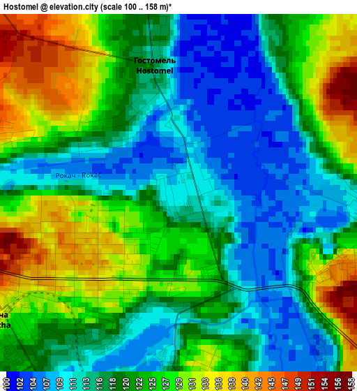
Below is the Elevation map of Hostomel, which displays elevation range with different colors. Scale of the first map is from 100 to 158 m (328 to 518 ft) with average elevation of 120.6 meters (=396 ft) [note 1]
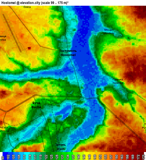
These maps also provides idea of topography and contour of this city, they are displayed at different zoom levels. More info about maps, scale and edge coordinates you can find below images.
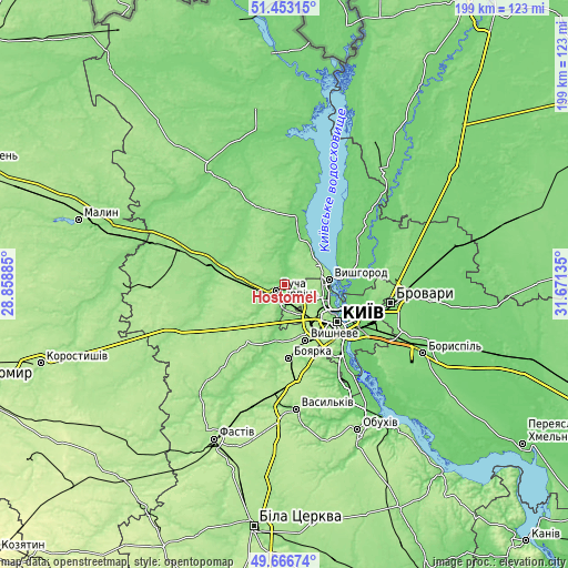
| \ | Map #1 | Map #2 | Topo.Map |
| Scale [m] | 100..158 m | 99..175 m | × |
| Scale [ft] | 328..518 ft | 325..574 ft | × |
| Average | 120.6 m = 396 ft | 134.5 m = 441 ft | × |
| Width | 6.21 km = 3.9 mi | 12.41 km = 7.7 mi | 198.6 km = 123.4 mi |
| Height | 6.21 km = 3.9 mi | 12.41 km = 7.7 mi | 198.6 km = 123.4 mi |
| ↑Max Latitude | 50.596314° | 50.624201° | 51.45315° |
| Latitude at center | 50.56841° | 50.56841° | 50.56841° |
| ↓Min Latitude | 50.54049° | 50.512553° | 49.66674° |
| ← Min Longitude | 30.221155° | 30.177209° | 28.85885° |
| Longitude center | 30.2651° | 30.2651° | 30.2651° |
| →Max Longitude | 30.309045° | 30.352991° | 31.67135° |
Nearby cities:
Cities around Hostomel sort by population:
• Kyiv elevation 187 m
22.2 km,  124°
124°
• Bucha 135 m
4.7 km,  233°
233°
• Irpin 121 m
5.3 km,  191°
191°
• Vyshneve 176 m
21.3 km,  159°
159°
• Vyshhorod 112 m
16 km,  83°
83°
• Kotsyubyns’ke 156 m
10 km,  152°
152°
• Vorzel’ 166 m
8.4 km,  251°
251°
• Novi Petrivtsi 161 m
14.2 km,  62°
62°
• Sofiyivska Borschagivka 163 m
19 km, 157°
• Horenka 123 m
4.9 km,  104°
104°
• Klavdiyevo-Tarasove 168 m
18 km,  275°
275°
• Liutizh 112 m
15.7 km,  35°
35°
Multilingual:
 En español:
Hostomel elevación 109 m.
 En France:
Hostomel élévation 109 m.
 Auf Deutsch:
Hostomel höhe über dem Meeresspiegel ist 109 m.

Sources and notes:
- [note 1] Map square and city borders are not equal. Map elevation data is calculated only from area inside that square.
- [src 1] Elevation data from geonames database provided with same terms of usage.
- [src 2] The elevation map of Hostomel is generated using elevation data from NASA's 3 arcsec (90m) resolution SRTM data.
- [src 3] Base (background) map © OpenStreetMap contributors tiles are generated by Geofabrik and OpenTopoMap.
Copyright & License:
This Hostomel Elevation Map is licensed under CC BY-SA. You may reuse any part from this page, if you give a proper credit by linking to this URL:
 More info on terms of use page.