Komarno elevation
Komarno (Lviv), Ukraine elevation is 262 meters and Komarno elevation in feet is 860 ft above sea level [src 1]. Komarno is a populated place (feature code) with elevation that is 105 meters (344 ft) bigger than average city elevation in Ukraine.
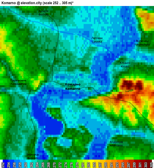
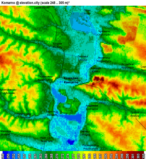
Below is the Elevation map of Komarno, which displays elevation range with different colors. Scale of the first map is from 252 to 305 m (827 to 1001 ft) with average elevation of 267.4 meters (=877 ft) [note 1]
These maps also provides idea of topography and contour of this city, they are displayed at different zoom levels. More info about maps, scale and edge coordinates you can find below images.
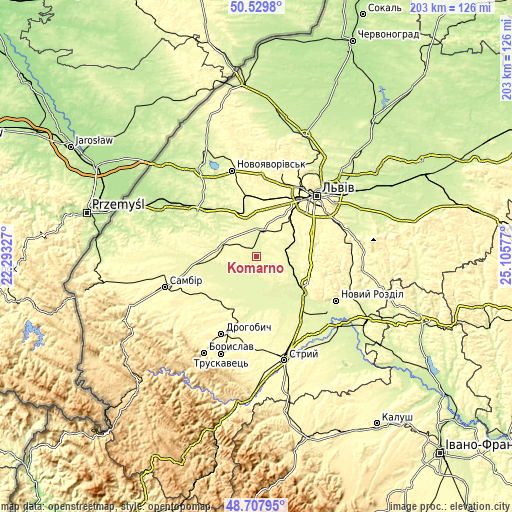
| \ | Map #1 | Map #2 | Topo.Map |
| Scale [m] | 252..305 m | 248..305 m | × |
| Scale [ft] | 827..1001 ft | 814..1001 ft | × |
| Average | 267.4 m = 877 ft | 272.4 m = 894 ft | × |
| Width | 6.33 km = 3.9 mi | 12.66 km = 7.9 mi | 202.6 km = 125.9 mi |
| Height | 6.33 km = 3.9 mi | 12.66 km = 7.9 mi | 202.6 km = 125.9 mi |
| ↑Max Latitude | 49.655848° | 49.684288° | 50.5298° |
| Latitude at center | 49.62739° | 49.62739° | 49.62739° |
| ↓Min Latitude | 49.598916° | 49.570425° | 48.70795° |
| ← Min Longitude | 23.655575° | 23.611629° | 22.29327° |
| Longitude center | 23.69952° | 23.69952° | 23.69952° |
| →Max Longitude | 23.743465° | 23.787411° | 25.10577° |
Nearby cities:
Cities around Komarno sort by population:
• Horodok elevation 280 m
17.9 km,  348°
348°
• Mykolaiv 290 m
23.6 km,  119°
119°
• Pustomyty 301 m
18.2 km,  57°
57°
• Shchyrets 260 m
12.9 km,  78°
78°
• Rudky 265 m
15.6 km,  280°
280°
• Obroshyne 302 m
21.1 km,  34°
34°
• Sukhovolya 301 m
24 km,  24°
24°
• Medenychi 268 m
22.2 km,  170°
170°
• Rozvadiv 261 m
23.4 km,  126°
126°
• Rodatychi 244 m
22.5 km,  327°
327°
• Demnya 257 m
19 km,  110°
110°
• Navaria 307 m
21.3 km,  50°
50°
Multilingual:
 En español:
Komarno elevación 262 m.
 En France:
Komarno élévation 262 m.


Sources and notes:
- [note 1] Map square and city borders are not equal. Map elevation data is calculated only from area inside that square.
- [src 1] Elevation data from geonames database provided with same terms of usage.
- [src 2] The elevation map of Komarno is generated using elevation data from NASA's 3 arcsec (90m) resolution SRTM data.
- [src 3] Base (background) map © OpenStreetMap contributors tiles are generated by Geofabrik and OpenTopoMap.
Copyright & License:
This Komarno Elevation Map is licensed under CC BY-SA. You may reuse any part from this page, if you give a proper credit by linking to this URL:
 More info on terms of use page.