Korolevo elevation
Korolevo (Transcarpathia), Ukraine elevation is 144 meters and Korolevo elevation in feet is 472 ft above sea level [src 1]. Korolevo is a populated place (feature code) with elevation that is 13 meters (43 ft) smaller than average city elevation in Ukraine.
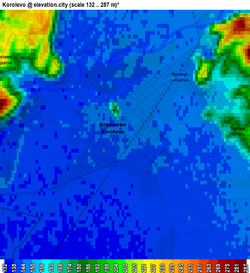
Below is the Elevation map of Korolevo, which displays elevation range with different colors. Scale of the first map is from 132 to 287 m (433 to 942 ft) with average elevation of 150.8 meters (=495 ft) [note 1]
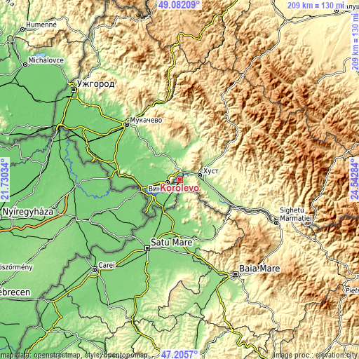
These maps also provides idea of topography and contour of this city, they are displayed at different zoom levels. More info about maps, scale and edge coordinates you can find below images.
| \ | Map #1 | Map #2 | Topo.Map |
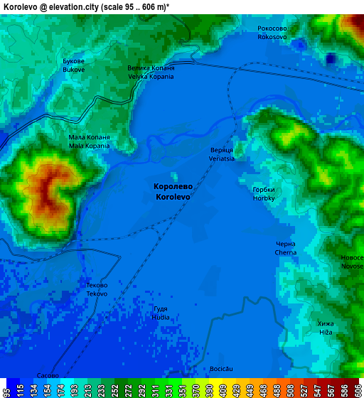
| Scale [m] | 132..287 m | 95..606 m | × |
| Scale [ft] | 433..942 ft | 312..1988 ft | × |
| Average | 150.8 m = 495 ft | 185.1 m = 607 ft | × |
| Width | 6.52 km = 4.1 mi | 13.04 km = 8.1 mi | 208.6 km = 129.6 mi |
| Height | 6.52 km = 4.1 mi | 13.04 km = 8.1 mi | 208.6 km = 129.6 mi |
| ↑Max Latitude | 48.18178° | 48.211073° | 49.08209° |
| Latitude at center | 48.15247° | 48.15247° | 48.15247° |
| ↓Min Latitude | 48.123143° | 48.0938° | 47.2057° |
| ← Min Longitude | 23.092645° | 23.048699° | 21.73034° |
| Longitude center | 23.13659° | 23.13659° | 23.13659° |
| →Max Longitude | 23.180535° | 23.224481° | 24.54284° |
Nearby cities:
Cities around Korolevo sort by population:
• Khust elevation 169 m
12.4 km,  76°
76°
• Vynohradiv 133 m
8.2 km,  261°
261°
• Irshava 140 m
19.7 km,  338°
338°
• Bilky 147 m
18.1 km,  359°
359°
• Iza 183 m
15.9 km,  63°
63°
• Oleshnyk 125 m
13 km,  275°
275°
• Rokosovo 177 m
7.1 km,  24°
24°
• Pidvynohradiv 129 m
12.3 km, 263°
• Lypcha 207 m
21.9 km, 56°
• Vylok 117 m
22.6 km, 257°
• Kryva 163 m
7.7 km,  73°
73°
• Bobovo 120 m
20 km,  243°
243°
Multilingual:
 En español:
Korolevo elevación 144 m.
 En France:
Korolevo élévation 144 m.
 Auf Deutsch:
Korolevo höhe über dem Meeresspiegel ist 144 m.

Sources and notes:
- [note 1] Map square and city borders are not equal. Map elevation data is calculated only from area inside that square.
- [src 1] Elevation data from geonames database provided with same terms of usage.
- [src 2] The elevation map of Korolevo is generated using elevation data from NASA's 3 arcsec (90m) resolution SRTM data.
- [src 3] Base (background) map © OpenStreetMap contributors tiles are generated by Geofabrik and OpenTopoMap.
Copyright & License:
This Korolevo Elevation Map is licensed under CC BY-SA. You may reuse any part from this page, if you give a proper credit by linking to this URL:
 More info on terms of use page.