Kryva Hora elevation
Kryva Hora (Kyiv), Ukraine elevation is 109 meters and Kryva Hora elevation in feet is 358 ft above sea level [src 1]. Kryva Hora is a abandoned populated place (feature code) with elevation that is 48 meters (157 ft) smaller than average city elevation in Ukraine.
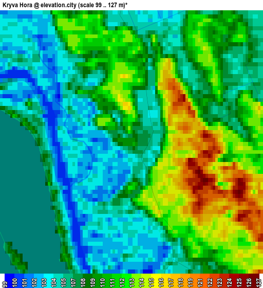
Below is the Elevation map of Kryva Hora, which displays elevation range with different colors. Scale of the first map is from 99 to 127 m (325 to 417 ft) with average elevation of 108.6 meters (=356 ft) [note 1]
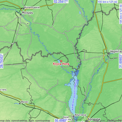
These maps also provides idea of topography and contour of this city, they are displayed at different zoom levels. More info about maps, scale and edge coordinates you can find below images.
| \ | Map #1 | Topo.Map |
| Scale [m] | 99..127 m | × |
| Scale [ft] | 325..417 ft | × |
| Average | 108.6 m = 356 ft | × |
| Width | 6.1 km = 3.8 mi | 195.2 km = 121.3 mi |
| Height | 6.1 km = 3.8 mi | 195.2 km = 121.3 mi |
| ↑Max Latitude | 51.412367° | 52.25417° |
| Latitude at center | 51.38495° | 51.38495° |
| ↓Min Latitude | 51.357516° | 50.4989° |
| ← Min Longitude | 30.155835° | 28.79353° |
| Longitude center | 30.19978° | 30.19978° |
| →Max Longitude | 30.243725° | 31.60603° |
Nearby cities:
Cities around Kryva Hora sort by population:
• Chernihiv elevation 127 m
76.4 km,  79°
79°
• Slavutych 131 m
39 km,  66°
66°
• Ivankiv 138 m
54 km,  203°
203°
• Ripky 145 m
76.6 km,  52°
52°
• Desna 115 m
64.2 km,  142°
142°
• Oster 114 m
67.8 km, 135°
• Dymer 111 m
66.9 km,  173°
173°
• Katyuzhanka 139 m
64.5 km,  183°
183°
• Lyubech 151 m
47.4 km,  41°
41°
• Narodychi 144 m
80.3 km,  255°
255°
• Liutizh 112 m
79.2 km, 170°
• Krasyatychi 139 m
51.5 km,  228°
228°
Multilingual:
 En español:
Kryva Hora elevación 109 m.
 En France:
Kryva Hora élévation 109 m.
 Auf Deutsch:
Kryva Hora höhe über dem Meeresspiegel ist 109 m.

Sources and notes:
- [note 1] Map square and city borders are not equal. Map elevation data is calculated only from area inside that square.
- [src 1] Elevation data from geonames database provided with same terms of usage.
- [src 2] The elevation map of Kryva Hora is generated using elevation data from NASA's 3 arcsec (90m) resolution SRTM data.
- [src 3] Base (background) map © OpenStreetMap contributors tiles are generated by Geofabrik and OpenTopoMap.
Copyright & License:
This Kryva Hora Elevation Map is licensed under CC BY-SA. You may reuse any part from this page, if you give a proper credit by linking to this URL:
 More info on terms of use page.