Kushuhum elevation
Kushuhum (Zaporizhia), Ukraine elevation is 53 meters and Kushuhum elevation in feet is 174 ft above sea level [src 1]. Kushuhum is a populated place (feature code) with elevation that is 104 meters (341 ft) smaller than average city elevation in Ukraine.
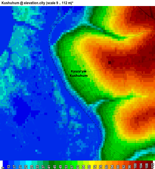
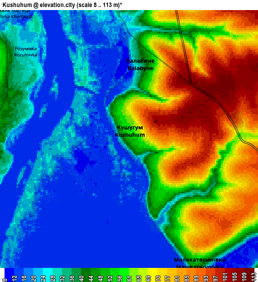
Below is the Elevation map of Kushuhum, which displays elevation range with different colors. Scale of the first map is from 9 to 112 m (30 to 367 ft) with average elevation of 43.5 meters (=143 ft) [note 1]
These maps also provides idea of topography and contour of this city, they are displayed at different zoom levels. More info about maps, scale and edge coordinates you can find below images.
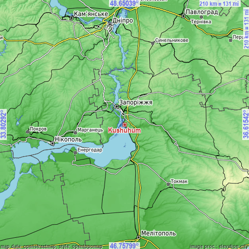
| \ | Map #1 | Map #2 | Topo.Map |
| Scale [m] | 9..112 m | 8..113 m | × |
| Scale [ft] | 30..367 ft | 26..371 ft | × |
| Average | 43.5 m = 143 ft | 43.8 m = 144 ft | × |
| Width | 6.58 km = 4.1 mi | 13.15 km = 8.2 mi | 210.4 km = 130.7 mi |
| Height | 6.58 km = 4.1 mi | 13.15 km = 8.2 mi | 210.4 km = 130.7 mi |
| ↑Max Latitude | 47.74234° | 47.771883° | 48.65039° |
| Latitude at center | 47.71278° | 47.71278° | 47.71278° |
| ↓Min Latitude | 47.683203° | 47.653609° | 46.75799° |
| ← Min Longitude | 35.165225° | 35.121279° | 33.80292° |
| Longitude center | 35.20917° | 35.20917° | 35.20917° |
| →Max Longitude | 35.253115° | 35.297061° | 36.61542° |
Nearby cities:
Cities around Kushuhum sort by population:
• Zaporizhia elevation 84 m
12.3 km,  353°
353°
• Marhanets’ 75 m
44.4 km,  258°
258°
• Dniprorudne 67 m
40.7 km,  205°
205°
• Vasylivka 39 m
31.1 km,  170°
170°
• Tomakivka 49 m
36.8 km,  288°
288°
• Balky 73 m
41.7 km, 208°
• Vil’ne 83 m
30.8 km,  253°
253°
• Komyshuvakha 29 m
24 km,  89°
89°
• Vyshchetarasivka 31 m
29.4 km,  236°
236°
• Kirove 37 m
37 km,  100°
100°
• Malokaterynivka 52 m
7.3 km,  150°
150°
• Vil’nyans’k 144 m
30.7 km,  33°
33°
Multilingual:
 En español:
Kushuhum elevación 53 m.
 En France:
Kushuhum élévation 53 m.


Sources and notes:
- [note 1] Map square and city borders are not equal. Map elevation data is calculated only from area inside that square.
- [src 1] Elevation data from geonames database provided with same terms of usage.
- [src 2] The elevation map of Kushuhum is generated using elevation data from NASA's 3 arcsec (90m) resolution SRTM data.
- [src 3] Base (background) map © OpenStreetMap contributors tiles are generated by Geofabrik and OpenTopoMap.
Copyright & License:
This Kushuhum Elevation Map is licensed under CC BY-SA. You may reuse any part from this page, if you give a proper credit by linking to this URL:
 More info on terms of use page.