Lokhvytsya elevation
Lokhvytsya (Poltava), Ukraine elevation is 104 meters and Lokhvytsya elevation in feet is 341 ft above sea level [src 1]. Lokhvytsya is a seat of a second-order administrative division (feature code) with elevation that is 53 meters (174 ft) smaller than average city elevation in Ukraine.
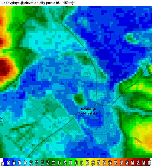
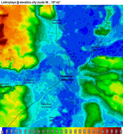
Below is the Elevation map of Lokhvytsya, which displays elevation range with different colors. Scale of the first map is from 98 to 159 m (322 to 522 ft) with average elevation of 110.5 meters (=363 ft) [note 1]
These maps also provides idea of topography and contour of this city, they are displayed at different zoom levels. More info about maps, scale and edge coordinates you can find below images.
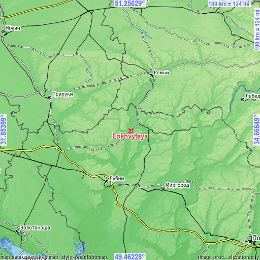
| \ | Map #1 | Map #2 | Topo.Map |
| Scale [m] | 98..159 m | 96..197 m | × |
| Scale [ft] | 322..522 ft | 315..646 ft | × |
| Average | 110.5 m = 363 ft | 123.5 m = 405 ft | × |
| Width | 6.23 km = 3.9 mi | 12.47 km = 7.7 mi | 199.5 km = 124 mi |
| Height | 6.23 km = 3.9 mi | 12.47 km = 7.7 mi | 199.5 km = 124 mi |
| ↑Max Latitude | 50.395783° | 50.423789° | 51.25629° |
| Latitude at center | 50.36776° | 50.36776° | 50.36776° |
| ↓Min Latitude | 50.339721° | 50.311665° | 49.46228° |
| ← Min Longitude | 33.216295° | 33.172349° | 31.85399° |
| Longitude center | 33.26024° | 33.26024° | 33.26024° |
| →Max Longitude | 33.304185° | 33.348131° | 34.66649° |
Nearby cities:
Cities around Lokhvytsya sort by population:
• Lubny elevation 153 m
43.3 km,  205°
205°
• Romny 157 m
45.2 km,  19°
19°
• Myrhorod 100 m
50.9 km,  150°
150°
• Varva 128 m
40.8 km,  290°
290°
• Lypova Dolyna 120 m
43.9 km,  60°
60°
• Sribne 166 m
40.8 km,  323°
323°
• Romodan 151 m
42.2 km,  173°
173°
• Chornukhy 114 m
25.2 km,  243°
243°
• Sencha 111 m
14 km, 154°
• Zhuravka 106 m
48.8 km,  284°
284°
• Komyshnya 141 m
36.3 km,  124°
124°
• Dihtyari 115 m
42.1 km,  304°
304°
Multilingual:
 En español:
Lokhvytsya elevación 104 m.
 En France:
Lokhvytsya élévation 104 m.
 Auf Deutsch:
Lokhvytsya höhe über dem Meeresspiegel ist 104 m.

Sources and notes:
- [note 1] Map square and city borders are not equal. Map elevation data is calculated only from area inside that square.
- [src 1] Elevation data from geonames database provided with same terms of usage.
- [src 2] The elevation map of Lokhvytsya is generated using elevation data from NASA's 3 arcsec (90m) resolution SRTM data.
- [src 3] Base (background) map © OpenStreetMap contributors tiles are generated by Geofabrik and OpenTopoMap.
Copyright & License:
This Lokhvytsya Elevation Map is licensed under CC BY-SA. You may reuse any part from this page, if you give a proper credit by linking to this URL:
 More info on terms of use page.