Novoarkhanhel’s’k elevation
Novoarkhanhel’s’k (Kirovohrad), Ukraine elevation is 134 meters and Novoarkhanhel’s’k elevation in feet is 440 ft above sea level [src 1]. Novoarkhanhel’s’k is a seat of a second-order administrative division (feature code) with elevation that is 23 meters (75 ft) smaller than average city elevation in Ukraine.
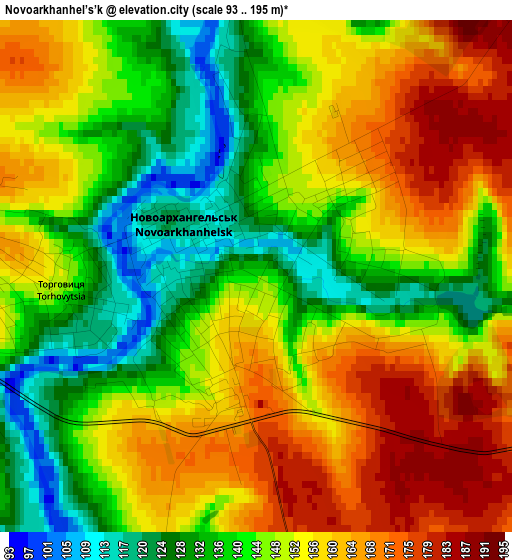
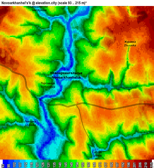
Below is the Elevation map of Novoarkhanhel’s’k, which displays elevation range with different colors. Scale of the first map is from 93 to 195 m (305 to 640 ft) with average elevation of 149.1 meters (=489 ft) [note 1]
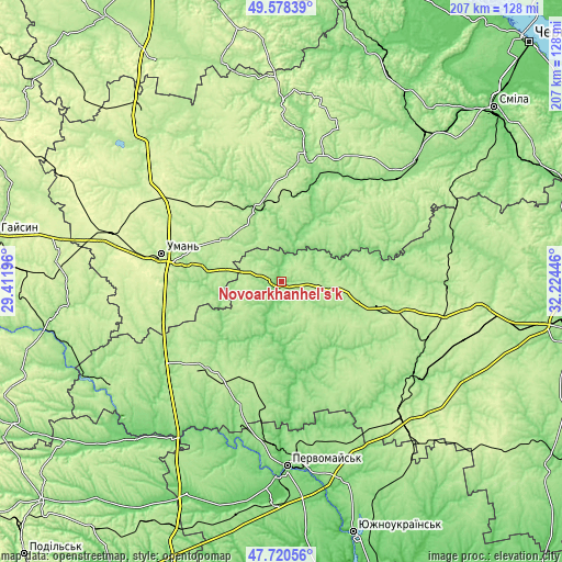
These maps also provides idea of topography and contour of this city, they are displayed at different zoom levels. More info about maps, scale and edge coordinates you can find below images.
| \ | Map #1 | Map #2 | Topo.Map |
| Scale [m] | 93..195 m | 93..215 m | × |
| Scale [ft] | 305..640 ft | 305..705 ft | × |
| Average | 149.1 m = 489 ft | 157.5 m = 517 ft | × |
| Width | 6.46 km = 4 mi | 12.91 km = 8 mi | 206.6 km = 128.4 mi |
| Height | 6.46 km = 4 mi | 12.91 km = 8 mi | 206.6 km = 128.4 mi |
| ↑Max Latitude | 48.68705° | 48.716053° | 49.57839° |
| Latitude at center | 48.65803° | 48.65803° | 48.65803° |
| ↓Min Latitude | 48.628993° | 48.59994° | 47.72056° |
| ← Min Longitude | 30.774265° | 30.730319° | 29.41196° |
| Longitude center | 30.81821° | 30.81821° | 30.81821° |
| →Max Longitude | 30.862155° | 30.906101° | 32.22446° |
Nearby cities:
Cities around Novoarkhanhel’s’k sort by population:
• Vatutine elevation 141 m
43.5 km,  24°
24°
• Talne 127 m
27.2 km,  340°
340°
• Lypnyazhka 131 m
30.2 km,  141°
141°
• Yerky 123 m
39 km, 18°
• Tyshkivka 174 m
20.1 km,  153°
153°
• Perehonivka 118 m
25.9 km,  238°
238°
• Yurkivka 128 m
43.9 km,  26°
26°
• Babanka 151 m
27.8 km,  281°
281°
• Holovanivs’k 174 m
40.2 km,  220°
220°
• Dobrovelychkivka 186 m
40.2 km, 138°
• Katerynopil 140 m
34.8 km, 18°
• Hlybochok 140 m
23.3 km,  356°
356°
Multilingual:
 En español:
Novoarkhanhel’s’k elevación 134 m.
 En France:
Novoarkhanhel’s’k élévation 134 m.
 Auf Deutsch:
Novoarkhanhel’s’k höhe über dem Meeresspiegel ist 134 m.

Sources and notes:
- [note 1] Map square and city borders are not equal. Map elevation data is calculated only from area inside that square.
- [src 1] Elevation data from geonames database provided with same terms of usage.
- [src 2] The elevation map of Novoarkhanhel’s’k is generated using elevation data from NASA's 3 arcsec (90m) resolution SRTM data.
- [src 3] Base (background) map © OpenStreetMap contributors tiles are generated by Geofabrik and OpenTopoMap.
Copyright & License:
This Novoarkhanhel’s’k Elevation Map is licensed under CC BY-SA. You may reuse any part from this page, if you give a proper credit by linking to this URL:
 More info on terms of use page.