Perovo elevation
Perovo (Republic of Crimea, Simferopol Raion), Ukraine elevation is 280 meters and Perovo elevation in feet is 919 ft above sea level [src 1]. Perovo is a seat of a third-order administrative division (feature code) with elevation that is 123 meters (404 ft) bigger than average city elevation in Ukraine.
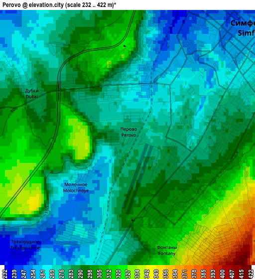
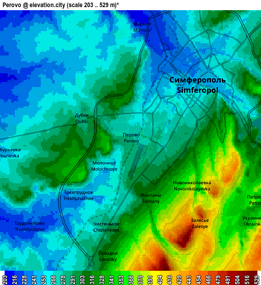
Below is the Elevation map of Perovo, which displays elevation range with different colors. Scale of the first map is from 232 to 422 m (761 to 1385 ft) with average elevation of 287.4 meters (=943 ft) [note 1]
These maps also provides idea of topography and contour of this city, they are displayed at different zoom levels. More info about maps, scale and edge coordinates you can find below images.
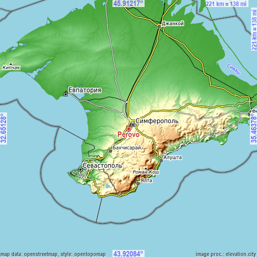
| \ | Map #1 | Map #2 | Topo.Map |
| Scale [m] | 232..422 m | 203..529 m | × |
| Scale [ft] | 761..1385 ft | 666..1736 ft | × |
| Average | 287.4 m = 943 ft | 292.3 m = 959 ft | × |
| Width | 6.92 km = 4.3 mi | 13.84 km = 8.6 mi | 221.4 km = 137.6 mi |
| Height | 6.92 km = 4.3 mi | 13.84 km = 8.6 mi | 221.4 km = 137.6 mi |
| ↑Max Latitude | 44.956236° | 44.987326° | 45.91217° |
| Latitude at center | 44.92513° | 44.92513° | 44.92513° |
| ↓Min Latitude | 44.894007° | 44.862867° | 43.92084° |
| ← Min Longitude | 34.013585° | 33.969639° | 32.65128° |
| Longitude center | 34.05753° | 34.05753° | 34.05753° |
| →Max Longitude | 34.101475° | 34.145421° | 35.46378° |
Nearby cities:
Cities around Perovo sort by population:
• Simferopol elevation 247 m
5.5 km,  49°
49°
• Mirnoye 214 m
6.5 km,  2°
2°
• Molodyozhnoye 219 m
8.7 km,  359°
359°
• Chisten’koye 306 m
4.9 km,  189°
189°
• Fontany 326 m
3.3 km,  158°
158°
• Ukrainka 356 m
7.7 km,  123°
123°
• Dubki 282 m
2.9 km,  293°
293°
• Beloglinka 205 m
7.9 km,  350°
350°
• Lozovoye 306 m
8.7 km,  104°
104°
• Konstantinovka 425 m
9.2 km,  147°
147°
• Zalesye 422 m
5.5 km,  140°
140°
• Levadki 320 m
6.1 km, 190°
Multilingual:
 En español:
Perovo elevación 280 m.
 En France:
Perovo élévation 280 m.


Sources and notes:
- [note 1] Map square and city borders are not equal. Map elevation data is calculated only from area inside that square.
- [src 1] Elevation data from geonames database provided with same terms of usage.
- [src 2] The elevation map of Perovo is generated using elevation data from NASA's 3 arcsec (90m) resolution SRTM data.
- [src 3] Base (background) map © OpenStreetMap contributors tiles are generated by Geofabrik and OpenTopoMap.
Copyright & License:
This Perovo Elevation Map is licensed under CC BY-SA. You may reuse any part from this page, if you give a proper credit by linking to this URL:
 More info on terms of use page.