Pohreby elevation
Pohreby (Kyiv), Ukraine elevation is 96 meters and Pohreby elevation in feet is 315 ft above sea level [src 1]. Pohreby is a populated place (feature code) with elevation that is 61 meters (200 ft) smaller than average city elevation in Ukraine.
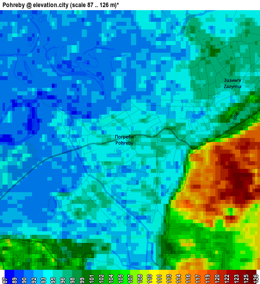
Below is the Elevation map of Pohreby, which displays elevation range with different colors. Scale of the first map is from 87 to 126 m (285 to 413 ft) with average elevation of 96.4 meters (=316 ft) [note 1]
These maps also provides idea of topography and contour of this city, they are displayed at different zoom levels. More info about maps, scale and edge coordinates you can find below images.
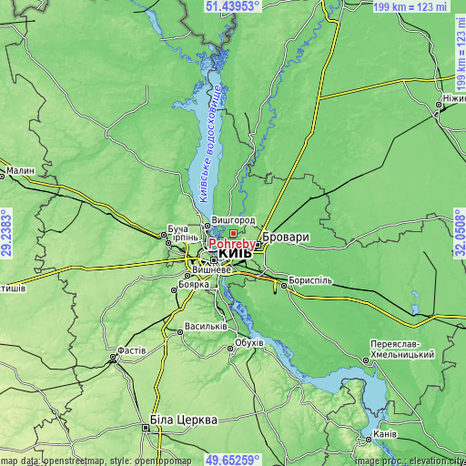
| \ | Map #1 | Topo.Map |
| Scale [m] | 87..126 m | × |
| Scale [ft] | 285..413 ft | × |
| Average | 96.4 m = 316 ft | × |
| Width | 6.21 km = 3.9 mi | 198.7 km = 123.5 mi |
| Height | 6.21 km = 3.9 mi | 198.7 km = 123.5 mi |
| ↑Max Latitude | 50.582442° | 51.43953° |
| Latitude at center | 50.55453° | 50.55453° |
| ↓Min Latitude | 50.526601° | 49.65259° |
| ← Min Longitude | 30.600605° | 29.2383° |
| Longitude center | 30.64455° | 30.64455° |
| →Max Longitude | 30.688495° | 32.0508° |
Nearby cities:
Cities around Pohreby sort by population:
• Kyiv elevation 187 m
14 km,  217°
217°
• Brovary 130 m
12.2 km,  109°
109°
• Vyshhorod 112 m
11.4 km,  287°
287°
• Kotsyubyns’ke 156 m
23.5 km,  251°
251°
• Velyka Dymerka 122 m
18.8 km,  76°
76°
• Novi Petrivtsi 161 m
16.4 km,  299°
299°
• Trebukhiv 114 m
19.9 km, 113°
• Horenka 123 m
22.1 km,  270°
270°
• Knyazhichi 111 m
14.2 km,  136°
136°
• Liutizh 112 m
22.8 km,  308°
308°
• Pukhivka 97 m
8 km,  40°
40°
• Prolisky 129 m
20.5 km,  152°
152°
Multilingual:
 En español:
Pohreby elevación 96 m.
 En France:
Pohreby élévation 96 m.


Sources and notes:
- [note 1] Map square and city borders are not equal. Map elevation data is calculated only from area inside that square.
- [src 1] Elevation data from geonames database provided with same terms of usage.
- [src 2] The elevation map of Pohreby is generated using elevation data from NASA's 3 arcsec (90m) resolution SRTM data.
- [src 3] Base (background) map © OpenStreetMap contributors tiles are generated by Geofabrik and OpenTopoMap.
Copyright & License:
This Pohreby Elevation Map is licensed under CC BY-SA. You may reuse any part from this page, if you give a proper credit by linking to this URL:
 More info on terms of use page.