Preobrazhenka elevation
Preobrazhenka (Zaporizhia), Ukraine elevation is 58 meters and Preobrazhenka elevation in feet is 190 ft above sea level [src 1]. Preobrazhenka is a populated place (feature code) with elevation that is 99 meters (325 ft) smaller than average city elevation in Ukraine.
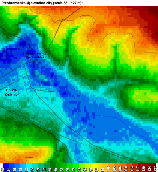
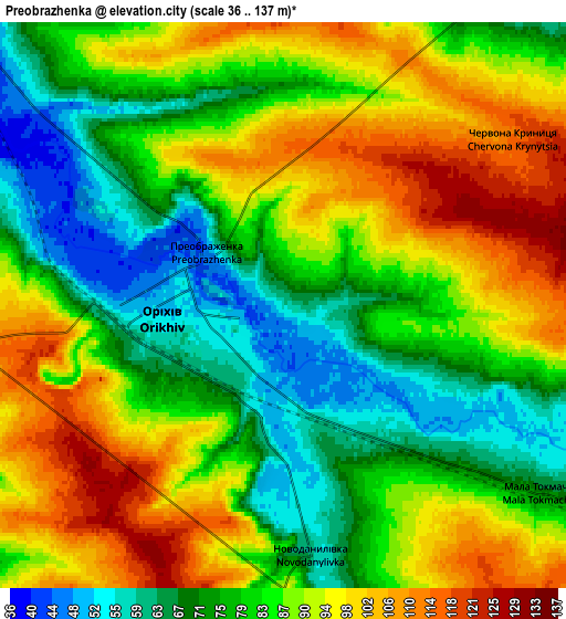
Below is the Elevation map of Preobrazhenka, which displays elevation range with different colors. Scale of the first map is from 38 to 127 m (125 to 417 ft) with average elevation of 70.4 meters (=231 ft) [note 1]
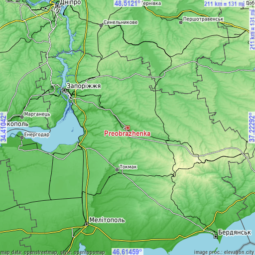
These maps also provides idea of topography and contour of this city, they are displayed at different zoom levels. More info about maps, scale and edge coordinates you can find below images.
| \ | Map #1 | Map #2 | Topo.Map |
| Scale [m] | 38..127 m | 36..137 m | × |
| Scale [ft] | 125..417 ft | 118..449 ft | × |
| Average | 70.4 m = 231 ft | 84.7 m = 278 ft | × |
| Width | 6.59 km = 4.1 mi | 13.19 km = 8.2 mi | 211 km = 131.1 mi |
| Height | 6.59 km = 4.1 mi | 13.19 km = 8.2 mi | 211 km = 131.1 mi |
| ↑Max Latitude | 47.60158° | 47.631203° | 48.5121° |
| Latitude at center | 47.57194° | 47.57194° | 47.57194° |
| ↓Min Latitude | 47.542283° | 47.51261° | 46.61459° |
| ← Min Longitude | 35.772725° | 35.728779° | 34.41042° |
| Longitude center | 35.81667° | 35.81667° | 35.81667° |
| →Max Longitude | 35.860615° | 35.904561° | 37.22292° |
Nearby cities:
Cities around Preobrazhenka sort by population:
• Tokmak elevation 48 m
36.1 km,  192°
192°
• Polohy 98 m
34.2 km,  106°
106°
• Orikhiv 57 m
2.4 km,  257°
257°
• Hulyaypole 112 m
34.5 km,  72°
72°
• Vasylivka 39 m
43.4 km,  249°
249°
• Komyshuvakha 29 m
26.8 km,  306°
306°
• Chapayevka 106 m
41.2 km, 105°
• Kirove 37 m
12.8 km, 314°
• Malokaterynivka 52 m
43 km,  282°
282°
• Mala Tokmachka 65 m
7 km,  125°
125°
• Ternuvate 154 m
37 km,  38°
38°
• Zaliznychne 152 m
27.6 km, 71°
Multilingual:
 En español:
Preobrazhenka elevación 58 m.
 En France:
Preobrazhenka élévation 58 m.
 Auf Deutsch:
Preobrazhenka höhe über dem Meeresspiegel ist 58 m.

Sources and notes:
- [note 1] Map square and city borders are not equal. Map elevation data is calculated only from area inside that square.
- [src 1] Elevation data from geonames database provided with same terms of usage.
- [src 2] The elevation map of Preobrazhenka is generated using elevation data from NASA's 3 arcsec (90m) resolution SRTM data.
- [src 3] Base (background) map © OpenStreetMap contributors tiles are generated by Geofabrik and OpenTopoMap.
Copyright & License:
This Preobrazhenka Elevation Map is licensed under CC BY-SA. You may reuse any part from this page, if you give a proper credit by linking to this URL:
 More info on terms of use page.