Privetnoye elevation
Privetnoye (Republic of Crimea, Gorodskoy okrug Alushta), Ukraine elevation is 60 meters and Privetnoye elevation in feet is 197 ft above sea level [src 1]. Privetnoye is a populated place (feature code) with elevation that is 97 meters (318 ft) smaller than average city elevation in Ukraine.
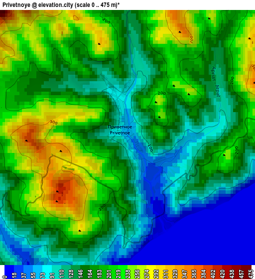
Below is the Elevation map of Privetnoye, which displays elevation range with different colors. Scale of the first map is from 0 to 475 m (0 to 1558 ft) with average elevation of 163.5 meters (=536 ft) [note 1]
These maps also provides idea of topography and contour of this city, they are displayed at different zoom levels. More info about maps, scale and edge coordinates you can find below images.
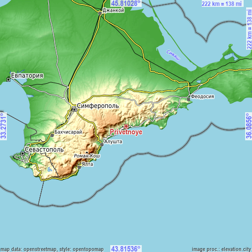
| \ | Map #1 | Topo.Map |
| Scale [m] | 0..475 m | × |
| Scale [ft] | 0..1558 ft | × |
| Average | 163.5 m = 536 ft | × |
| Width | 6.93 km = 4.3 mi | 221.8 km = 137.8 mi |
| Height | 6.93 km = 4.3 mi | 221.8 km = 137.8 mi |
| ↑Max Latitude | 44.852612° | 45.81028° |
| Latitude at center | 44.82145° | 44.82145° |
| ↓Min Latitude | 44.790271° | 43.81536° |
| ← Min Longitude | 34.635405° | 33.2731° |
| Longitude center | 34.67935° | 34.67935° |
| →Max Longitude | 34.723295° | 36.0856° |
Nearby cities:
Cities around Privetnoye sort by population:
• Sudak elevation 33 m
23.5 km,  82°
82°
• Morskoye 30 m
9.8 km,  87°
87°
• Vesele 148 m
16.3 km, 75°
• Rybach'e 17 m
8.5 km,  230°
230°
• Malorechenskoye 17 m
11.8 km, 234°
• Chernopolye 227 m
24.9 km,  352°
352°
• Novy Svet 39 m
18.5 km, 86°
• Luchistoye 498 m
23.9 km,  246°
246°
• Solnechnogorskoye 23 m
13.8 km, 233°
• Bogatoye 286 m
24.1 km,  16°
16°
• Krinichnoye 234 m
23.2 km, 346°
• Zemlyanichnoye 330 m
21 km,  35°
35°
Multilingual:
 En español:
Privetnoye elevación 60 m.
 En France:
Privetnoye élévation 60 m.
 Auf Deutsch:
Privetnoye höhe über dem Meeresspiegel ist 60 m.

Sources and notes:
- [note 1] Map square and city borders are not equal. Map elevation data is calculated only from area inside that square.
- [src 1] Elevation data from geonames database provided with same terms of usage.
- [src 2] The elevation map of Privetnoye is generated using elevation data from NASA's 3 arcsec (90m) resolution SRTM data.
- [src 3] Base (background) map © OpenStreetMap contributors tiles are generated by Geofabrik and OpenTopoMap.
Copyright & License:
This Privetnoye Elevation Map is licensed under CC BY-SA. You may reuse any part from this page, if you give a proper credit by linking to this URL:
 More info on terms of use page.