Rozhniativ elevation
Rozhniativ (Ivano-Frankivsk), Ukraine elevation is 362 meters and Rozhniativ elevation in feet is 1188 ft above sea level [src 1]. Rozhniativ is a seat of a second-order administrative division (feature code) with elevation that is 205 meters (673 ft) bigger than average city elevation in Ukraine.
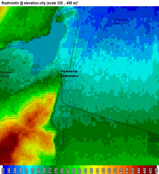
Below is the Elevation map of Rozhniativ, which displays elevation range with different colors. Scale of the first map is from 335 to 458 m (1099 to 1503 ft) with average elevation of 373.3 meters (=1225 ft) [note 1]
These maps also provides idea of topography and contour of this city, they are displayed at different zoom levels. More info about maps, scale and edge coordinates you can find below images.
| \ | Map #1 | Map #2 | Topo.Map |
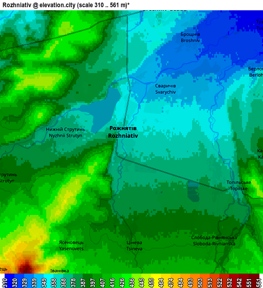
| Scale [m] | 335..458 m | 310..561 m | × |
| Scale [ft] | 1099..1503 ft | 1017..1841 ft | × |
| Average | 373.3 m = 1225 ft | 385.3 m = 1264 ft | × |
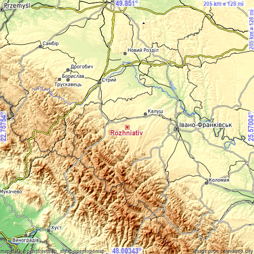
| Width | 6.42 km = 4 mi | 12.84 km = 8 mi | 205.4 km = 127.6 mi |
| Height | 6.42 km = 4 mi | 12.84 km = 8 mi | 205.4 km = 127.6 mi |
| ↑Max Latitude | 48.96462° | 48.993462° | 49.851° |
| Latitude at center | 48.93576° | 48.93576° | 48.93576° |
| ↓Min Latitude | 48.906884° | 48.877991° | 48.00343° |
| ← Min Longitude | 24.119845° | 24.075899° | 22.75754° |
| Longitude center | 24.16379° | 24.16379° | 24.16379° |
| →Max Longitude | 24.207735° | 24.251681° | 25.57004° |
Nearby cities:
Cities around Rozhniativ sort by population:
• Kalush elevation 279 m
17.5 km,  61°
61°
• Dolyna 404 m
12 km,  290°
290°
• Bolekhiv 365 m
26.2 km,  303°
303°
• Kosmach 479 m
25.4 km,  144°
144°
• Broshniv-Osada 349 m
7.2 km,  20°
20°
• Svarychiv 341 m
3.8 km,  39°
39°
• Novytsya 317 m
12.9 km,  76°
76°
• Stari Bohorodchany 312 m
28.7 km,  113°
113°
• Nebyliv 474 m
13.9 km,  163°
163°
• Porohy 548 m
28.5 km,  165°
165°
• Spas 423 m
9 km,  235°
235°
• Petranka 381 m
10.9 km, 109°
Multilingual:
 En español:
Rozhniativ elevación 362 m.
 En France:
Rozhniativ élévation 362 m.
 Auf Deutsch:
Rozhniativ höhe über dem Meeresspiegel ist 362 m.

Sources and notes:
- [note 1] Map square and city borders are not equal. Map elevation data is calculated only from area inside that square.
- [src 1] Elevation data from geonames database provided with same terms of usage.
- [src 2] The elevation map of Rozhniativ is generated using elevation data from NASA's 3 arcsec (90m) resolution SRTM data.
- [src 3] Base (background) map © OpenStreetMap contributors tiles are generated by Geofabrik and OpenTopoMap.
Copyright & License:
This Rozhniativ Elevation Map is licensed under CC BY-SA. You may reuse any part from this page, if you give a proper credit by linking to this URL:
 More info on terms of use page.