Seredyna-Buda elevation
Seredyna-Buda (Sumy), Ukraine elevation is 194 meters and Seredyna-Buda elevation in feet is 636 ft above sea level [src 1]. Seredyna-Buda is a seat of a second-order administrative division (feature code) with elevation that is 37 meters (121 ft) bigger than average city elevation in Ukraine.
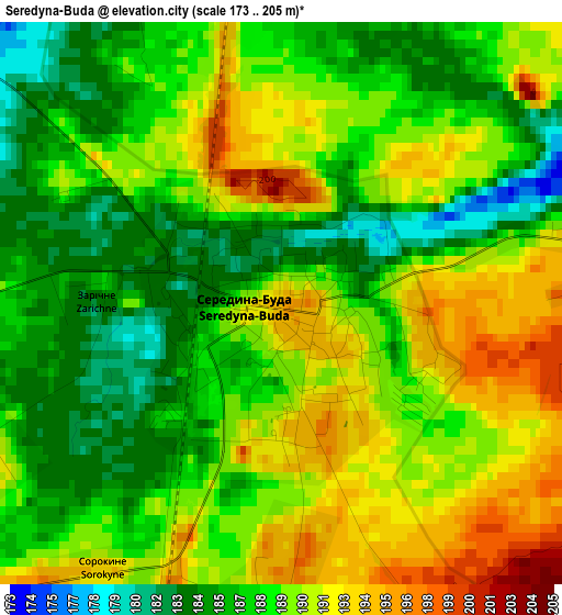
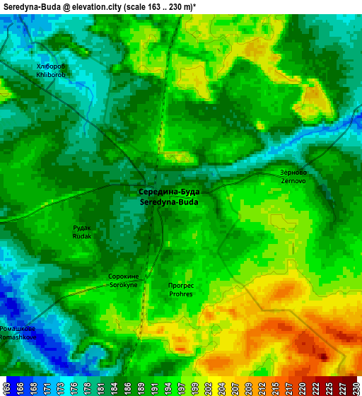
Below is the Elevation map of Seredyna-Buda, which displays elevation range with different colors. Scale of the first map is from 173 to 205 m (568 to 673 ft) with average elevation of 188.7 meters (=619 ft) [note 1]
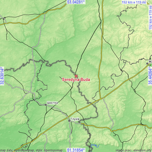
These maps also provides idea of topography and contour of this city, they are displayed at different zoom levels. More info about maps, scale and edge coordinates you can find below images.
| \ | Map #1 | Map #2 | Topo.Map |
| Scale [m] | 173..205 m | 163..230 m | × |
| Scale [ft] | 568..673 ft | 535..755 ft | × |
| Average | 188.7 m = 619 ft | 189.9 m = 623 ft | × |
| Width | 5.99 km = 3.7 mi | 11.98 km = 7.4 mi | 191.7 km = 119.1 mi |
| Height | 5.99 km = 3.7 mi | 11.98 km = 7.4 mi | 191.7 km = 119.1 mi |
| ↑Max Latitude | 52.215963° | 52.242879° | 53.04281° |
| Latitude at center | 52.18903° | 52.18903° | 52.18903° |
| ↓Min Latitude | 52.162081° | 52.135115° | 51.31854° |
| ← Min Longitude | 33.992445° | 33.948499° | 32.63014° |
| Longitude center | 34.03639° | 34.03639° | 34.03639° |
| →Max Longitude | 34.080335° | 34.124281° | 35.44264° |
Nearby cities:
Cities around Seredyna-Buda sort by population:
• Shostka elevation 154 m
53.1 km,  226°
226°
• Hlukhiv 169 m
57.4 km,  188°
188°
• Krolevets’ 166 m
84.2 km,  212°
212°
• Putyvl’ 184 m
95.4 km, 186°
• Novhorod-Sivers’kyy 159 m
56.7 km,  248°
248°
• Semenivka 160 m
99.2 km,  269°
269°
• Yampil’ 157 m
31.8 km, 212°
• Korop 126 m
101.3 km, 226°
• Druzhba 185 m
17.1 km,  201°
201°
• Shalyhyne 160 m
68.9 km,  175°
175°
• Avdiyivka 169 m
96.3 km,  241°
241°
• Yesman’ 184 m
46.6 km, 177°
Multilingual:
 En español:
Seredyna-Buda elevación 194 m.
 En France:
Seredyna-Buda élévation 194 m.
 Auf Deutsch:
Seredyna-Buda höhe über dem Meeresspiegel ist 194 m.

Sources and notes:
- [note 1] Map square and city borders are not equal. Map elevation data is calculated only from area inside that square.
- [src 1] Elevation data from geonames database provided with same terms of usage.
- [src 2] The elevation map of Seredyna-Buda is generated using elevation data from NASA's 3 arcsec (90m) resolution SRTM data.
- [src 3] Base (background) map © OpenStreetMap contributors tiles are generated by Geofabrik and OpenTopoMap.
Copyright & License:
This Seredyna-Buda Elevation Map is licensed under CC BY-SA. You may reuse any part from this page, if you give a proper credit by linking to this URL:
 More info on terms of use page.