Talalayivka elevation
Talalayivka (Chernihiv), Ukraine elevation is 128 meters and Talalayivka elevation in feet is 420 ft above sea level [src 1]. Talalayivka is a populated place (feature code) with elevation that is 29 meters (95 ft) smaller than average city elevation in Ukraine.
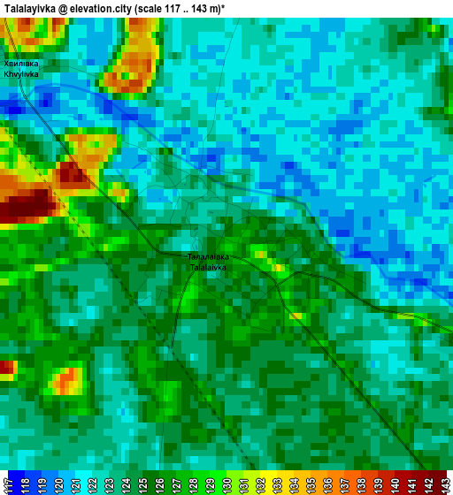
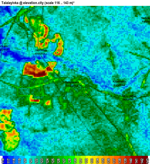
Below is the Elevation map of Talalayivka, which displays elevation range with different colors. Scale of the first map is from 117 to 143 m (384 to 469 ft) with average elevation of 123.7 meters (=406 ft) [note 1]
These maps also provides idea of topography and contour of this city, they are displayed at different zoom levels. More info about maps, scale and edge coordinates you can find below images.
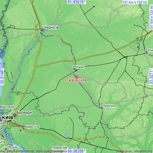
| \ | Map #1 | Map #2 | Topo.Map |
| Scale [m] | 117..143 m | 116..143 m | × |
| Scale [ft] | 384..469 ft | 381..469 ft | × |
| Average | 123.7 m = 406 ft | 123.1 m = 404 ft | × |
| Width | 6.16 km = 3.8 mi | 12.31 km = 7.6 mi | 197 km = 122.4 mi |
| Height | 6.16 km = 3.8 mi | 12.31 km = 7.6 mi | 197 km = 122.4 mi |
| ↑Max Latitude | 50.985503° | 51.013159° | 51.83519° |
| Latitude at center | 50.95783° | 50.95783° | 50.95783° |
| ↓Min Latitude | 50.930141° | 50.902435° | 50.06358° |
| ← Min Longitude | 31.876905° | 31.832959° | 30.5146° |
| Longitude center | 31.92085° | 31.92085° | 31.92085° |
| →Max Longitude | 31.964795° | 32.008741° | 33.3271° |
Nearby cities:
Cities around Talalayivka sort by population:
• Nizhyn elevation 128 m
10.3 km,  346°
346°
• Pryluky 127 m
52.2 km,  141°
141°
• Nosivka 121 m
23.9 km,  262°
262°
• Ichnya 155 m
34.8 km,  107°
107°
• Bobrovytsya 131 m
43.7 km,  237°
237°
• Borzna 130 m
48.3 km,  46°
46°
• Zgurovka 126 m
51.5 km,  190°
190°
• Kulykivka 119 m
50 km,  337°
337°
• Kobyzhcha 131 m
32.6 km, 243°
• Lisovi Sorochyntsi 147 m
41.4 km, 136°
• Olyshivka 118 m
50.5 km,  305°
305°
• Kruty 126 m
17.2 km, 48°
Multilingual:
 En español:
Talalayivka elevación 128 m.
 En France:
Talalayivka élévation 128 m.
 Auf Deutsch:
Talalayivka höhe über dem Meeresspiegel ist 128 m.

Sources and notes:
- [note 1] Map square and city borders are not equal. Map elevation data is calculated only from area inside that square.
- [src 1] Elevation data from geonames database provided with same terms of usage.
- [src 2] The elevation map of Talalayivka is generated using elevation data from NASA's 3 arcsec (90m) resolution SRTM data.
- [src 3] Base (background) map © OpenStreetMap contributors tiles are generated by Geofabrik and OpenTopoMap.
Copyright & License:
This Talalayivka Elevation Map is licensed under CC BY-SA. You may reuse any part from this page, if you give a proper credit by linking to this URL:
 More info on terms of use page.