Boykivske elevation
Boykivske (Donetsk, Boykivske Raion), Ukraine elevation is 104 meters and Boykivske elevation in feet is 341 ft above sea level [src 1]. Boykivske is a seat of a second-order administrative division (feature code) with elevation that is 53 meters (174 ft) smaller than average city elevation in Ukraine.
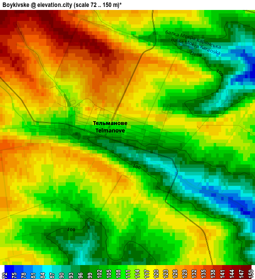
Below is the Elevation map of Boykivske, which displays elevation range with different colors. Scale of the first map is from 72 to 150 m (236 to 492 ft) with average elevation of 112 meters (=367 ft) [note 1]
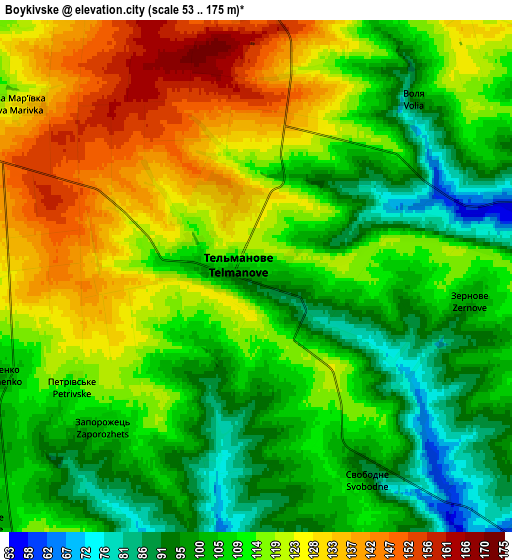
These maps also provides idea of topography and contour of this city, they are displayed at different zoom levels. More info about maps, scale and edge coordinates you can find below images.
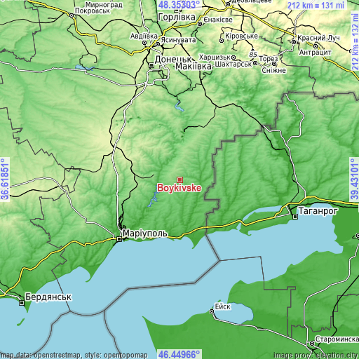
| \ | Map #1 | Map #2 | Topo.Map |
| Scale [m] | 72..150 m | 53..175 m | × |
| Scale [ft] | 236..492 ft | 174..574 ft | × |
| Average | 112 m = 367 ft | 112.7 m = 370 ft | × |
| Width | 6.61 km = 4.1 mi | 13.23 km = 8.2 mi | 211.6 km = 131.5 mi |
| Height | 6.61 km = 4.1 mi | 13.23 km = 8.2 mi | 211.6 km = 131.5 mi |
| ↑Max Latitude | 47.439672° | 47.469386° | 48.35303° |
| Latitude at center | 47.40994° | 47.40994° | 47.40994° |
| ↓Min Latitude | 47.380192° | 47.350427° | 46.44966° |
| ← Min Longitude | 37.980815° | 37.936869° | 36.61851° |
| Longitude center | 38.02476° | 38.02476° | 38.02476° |
| →Max Longitude | 38.068705° | 38.112651° | 39.43101° |
Nearby cities:
Cities around Boykivske sort by population:
• Mariupol elevation 65 m
50.6 km,  226°
226°
• Dokuchayevs’k 158 m
45.9 km,  325°
325°
• Volnovakha 260 m
45 km,  298°
298°
• Novoazovs'k 24 m
33.2 km,  172°
172°
• Mospyne 140 m
53.5 km,  3°
3°
• Sartana 13 m
36.2 km,  223°
223°
• Novyy Svit 121 m
44 km,  359°
359°
• Starobesheve 126 m
37.9 km, 0°
• Staryy Krym 45 m
48.9 km,  235°
235°
• Syedove 2 m
38.3 km, 165°
• Bezimenne 14 m
34.3 km,  190°
190°
• Kuteynykove 193 m
48.9 km,  23°
23°
Multilingual:
 En español:
Boykivske elevación 104 m.
 En France:
Boïkivske élévation 104 m.
 Auf Deutsch:
Bojkiwske, Telmanowe, Ostheim höhe über dem Meeresspiegel ist 104 m.
 На русском:
Tel’manovo, Тельманово высота над уровнем моря 104 м
Sources and notes:
- [note 1] Map square and city borders are not equal. Map elevation data is calculated only from area inside that square.
- [src 1] Elevation data from geonames database provided with same terms of usage.
- [src 2] The elevation map of Boykivske is generated using elevation data from NASA's 3 arcsec (90m) resolution SRTM data.
- [src 3] Base (background) map © OpenStreetMap contributors tiles are generated by Geofabrik and OpenTopoMap.
Copyright & License:
This Boykivske Elevation Map is licensed under CC BY-SA. You may reuse any part from this page, if you give a proper credit by linking to this URL:
 More info on terms of use page.